Active swell windows for the week ahead

Sydney, Hunter and Illawarra Surf Forecast by Guy Dixon (issued Friday 18th December)
Best Days: Saturday and Sunday morning at open beaches. Wednesday at south facing beaches.
Recap:
Tiny conditions continued throughout yesterday with most coasts only offering options in the 1-1.5ft range, slightly bigger across the Hunter. Light/calm-offshore breezes kept the line up glassy for those who fancied a long board session, with a light/moderate seabreeze then kicking in.
Today has been much the same, starting off undersized with options barely reaching the 2ft mark across most coasts. Light northerly winds allowed for clean conditions early preceding a light/moderate seabreeze.
This weekend (Saturday 19th - Sunday 20th):
A northerly fetch hugging the NSW coast is expected to broaden and intensify today, providing a much needed increase in size across the open beaches for the weekend.
Saturday is expected to build to the 2ft range by the afternoon across the open beaches, with a hint of back ground southerly energy also in the mix, providing a few tiny options at south facing beaches.
The early session is looking clean and workable for the start to the weekend with a light northerly airflow, potentially tending northwesterly locally for most spots. As the day progresses a northeasterly seabreeze is likely to pick up, impacting the quality of the line up.
Sunday will see this northerly fetch increase further, initially along the South Coast which has the potential to build to the 3-5ft range, smaller in Sydney more in the 3ft range with the odd bigger set for the very late session.
You may be able to sneak a wave early under a light/moderate northerly breeze, but make it quick as a northeasterly breeze is expected to soon increase, becoming fairly gusty along open stretches.
Next week (Monday 21st onward):
A fairly abrupt southerly change is looking to move up the coast fairly early on Monday morning. Firstly, the window of light winds with this change looks brief and secondly, the timing could be tricky for places south of Sydney.
The period of daylight before southerly breezes start having an impact on the quality will be fairly short for most places south of Sydney, with more of an opportunity for a wave along the Hunter coast. The north-east windswell should be easing from 3ft to possibly 4ft at dawn across north-east facing beaches.
Following the change, protected southern corners of the open beaches will be the pick of the bunch, offering good protection from a less than ideal breeze and picking up left over northeasterly energy in the 2-3ft range.
A local southerly windswell following the change should build across the south facing beaches, although only modest, building to the 2ft range as breezes don't look overly sustained.
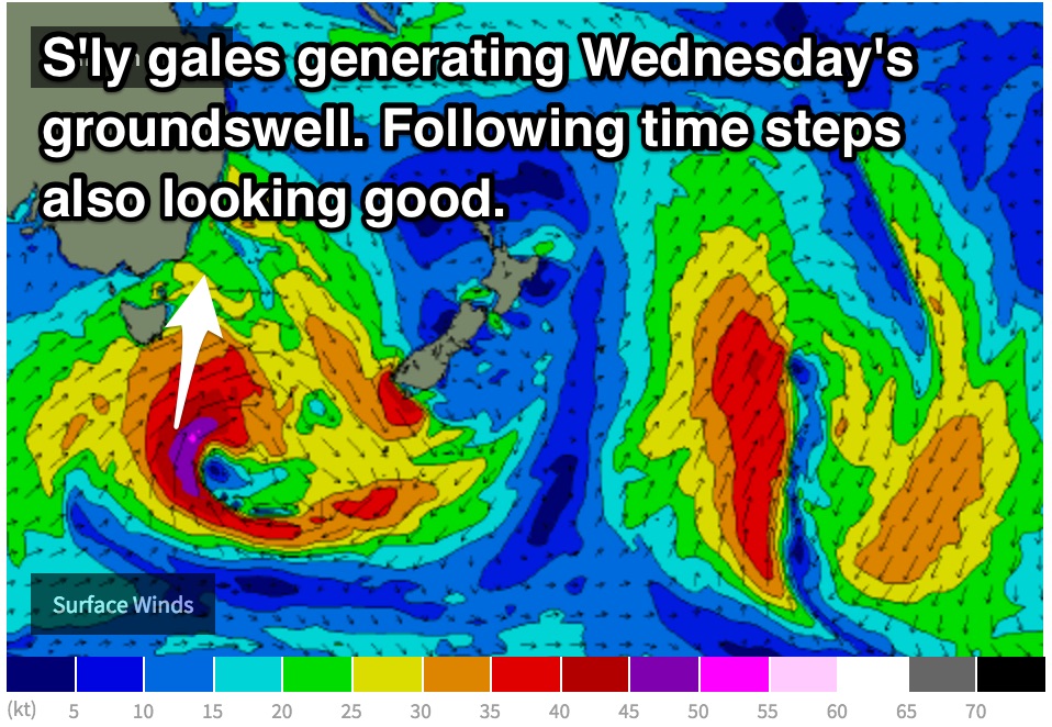
The main southerly pulse looks to fill from Tuesday, building to the 3ft range late with much more substantial periods, peaking on Wednesday in the 3-5ft range.
The alignment and intensity of these southerly fetches with the front and low generating this southerly groundswell look good, although moving east fairly quickly. Our surface wind WAMS show this system well, from about 6pm Sunday onwards (http://www.swellnet.com/reports/australia/new-south-wales/northern-beaches/wams).
Tuesday’s breeze leave a bit to be desired, light/moderate southerly at first, increasing from the east/southeast in the afternoon and evening. Wednesday, although onshore, looks much more workable as breezes should remain light for most of the day. Most spots will be crumbly, but easily workable.
The size across south facing beaches is then expected to fade from the 4ft range off the back of this solid southerly swell throughout Thursday, however a second source of swell should have become well established by this stage.
A strong Tasman ridge is looking to replace the front and low as it moves to the southeast, steering a persistent and well aligned easterly airflow flow towards the NSW coast.
Open beaches should offer fairly consistent options in the 2ft range for the remainder of the week and into the early stage of the weekend.
Winds are expected to prevail from the east/northeast on Thursday, increasing from the northeast on Friday as the cycle repeats itself.
Comments
Look closely at the back of this boat.. trawls regularily between Manly and the upper Northern Beaches.
Decent size noah
No rego/id numbers on the boat ?
Maybe photoshopped out?
Here's the same boat in 2011 out in dangerous water inside the Q Bommie..
Something in black on back side, but zoomed in and can't make out..