Trade-swell for the week. Open beaches are the go each morning

Sydney, Hunter and Illawarra Surf Forecast by Guy Dixon (issued Monday 30th November)
Best Days: Each morning Tuesday, Friday, Saturday and Sunday.
Recap:
Persistent onshore breezes had an impact on the quality of the surf over the weekend, however residual size off the back of Friday’s south swell allowed for some workable peaks.
Saturday offered surf in the 2-3ft range, biggest and cleanest at northern corners of south facing beaches under an east/northeasterly airflow. Sunday was a similar story, with options in the 2-3ft range under a north/northeasterly breeze.
As usual on a south swell, the Hunter picked up a touch more size, with the surf holding in the 3ft range for much of the weekend.
As for today, the surf has faded further to the 2ft range. An early southwesterly airflow created a few issues for exposed south facing beaches and much of the Hunter. Breezes have now swung easterly, so most beaches are pretty ordinary.
This week (Tuesday 1st - Friday 4th):
In the past few forecast notes, we have been monitoring a tropical depression located within the vicinity of Fiji which has since developed into Tropcial Cyclone Tuni. This system has been generating some healthy easterly fetches across it’s southern quadrants, however up until now, the energy felt off this system has been fairly subtle and often overshadowed by larger swells.
As of Tuesday, this energy is expected to be the more dominant swell in the water, providing surf in the 2-3ft range of open beaches, although very inconsistent.
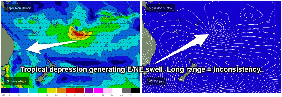 The effects from Tuni are expected to be long lasting, due to the prolonged and stationary nature of the system. So we should feel its impacts across open beaches throughout the week, likely peaking on Friday and Saturday at around 3ft from a slight intensification earlier in the week. Energy is then expected to gradually ease from Sunday throughout next week.
A small amount of southerly energy will also remain in the water, although likely undersized in the 1-2ft range at south swell magnets.
The morning session is likely to be the pick for Tuesday, with light winds prevailing from the north/northwest first thing. As the morning progresses, a northeasterly see breeze will strengthen, having an impact on the quality of the surf, especially at open beaches which will be offering the most size.
By the afternoon, this gusty northeasterly seabreeze should have generated a short range windswell to around 2-3ft for the open beaches. As expected, the quality won’t be anything to get excited about.
A southerly change is due to move up the coast overnight, likely moving over the Sydney coast in the very early hours of Wednesday morning.
A short range southerly windswell generated by this change is expected to build throughout Wednesday, providing options in the 3-4ft+ range by the afternoon. Winds will heavily limit options to the protected corners of open beaches where the east/northeasterly energy will be filling in. South facing beaches, although bigger, will be wind affected and not worth much consideration.
This short range energy is likely to fade steadily from the 3-4ft range throughout Thursday, however, a fetch of southwesterly gales off the far South Coast/far east Bass Strait on Wednesday afternoon is likely to add an element of southerly groundswell into the mix.
This groundswell will only be modest due to it’s short duration, poor alignment and size, however it will slow the easing trend slightly. South facing beaches should still be offering poor/variable quality options in the 3ft range by the afternoon, impacted by an easting southeasterly airflow.
Residual southerly swell is expected to continue fading throughout Friday from the 2-3ft range.
Winds look to be light/variable/onshore in the morning, before giving way to a light easterly seabreeze throughout the day. This seabreeze should increase slightly throughout the day, however conditions should be at their cleanest on this day, particularly in the morning.
There are very few indications of significant southerly swell generators moving through the swell window, so open beaches will remain the focus, as long range east/northeasterly energy continues to fill in.
This weekend (Saturday 5th - Sunday 6th):
Weak frontal activity is expected to add hints of southerly energy into the mix for the weekend, however the size and period is negligible and not really worth considering.
The primary swell will be east/northeasterly trade energy holding in the 3ft range at open beaches on Saturday and the best parts of Sunday, fading slightly.
Saturday morning is looking at light variable winds, tending northeasterly throughout the day. Sunday morning also has a good window of opportunity in the morning, before an easterly seabreeze kicks in.
Next week (Monday 7th onward):
Further ahead, easterly trade energy will gradually ease throughout the week. However, long range frontal activity is on the cards for late stages of the weekend which would provide southerly energy for the early-mid stages of next week. At this stage, it looks as though a pulse is due to build from late Tuesday into Wednesday to the inconsistent 2-3ft range at south facing beaches.
More detail on Wednesday.