Dribbles of surf in coming days, potential large swell late next week

Sydney, Hunter and Illawarra Surf Forecast by Guy Dixon (issued Friday 13th November)
Best Days: Tuesday morning and Wednesday morning
Recap:
A southerly groundswell built along the NSW coast throughout Thursday and kicked harder than expected in the afternoon, with sets reaching into the 3-4ft range at south facing beaches late in the day. The quality of the surf was only fair throughout the day under a northeasterly air flow, but south facing beaches were offering workable options.
Models overcooked the northerly breezes in the overnight hours from Thursday into Friday and also had them persisting until just before sunrise. We were pleasantly surprised checking the observations that winds were quite light across the coast overnight, with partly wobbly, but generally workable conditions at dawn. As the morning progressed, conditions became more refined with plenty of clean peaks off a mix of southerly groundswell and northeasterly windswell in the 3ft along the coast.
This weekend (Saturday 14th - Sunday 15th):
In the early hours of this morning, a low pressure system developed within a deep trough just east of Tasmania, which is still on track to provide southerly for the NSW coast on Saturday, albeit less substantial than originally thought.
Southerly fetches on the western quadrants of this system are no longer aligned very well, and the duration of these winds is fairly brief. Nevertheless, we should see around 2ft of underlying groundswell fill in across the exposed south swell magnets on Saturday afternoon.
A more notable source of swell for Saturday, particularly in the morning will be short range southerly energy to the 2ft range following this afternoon’s weak change.
In all aspects, this combination of southerly swell is looking fairly forgettable, mainly due to persistent southeasterly breezes right along the coast (likely S/SW on the Northern Beaches early). It’s going to be tricky to find a clean wave and protected spots are likely to lacking size and energy.
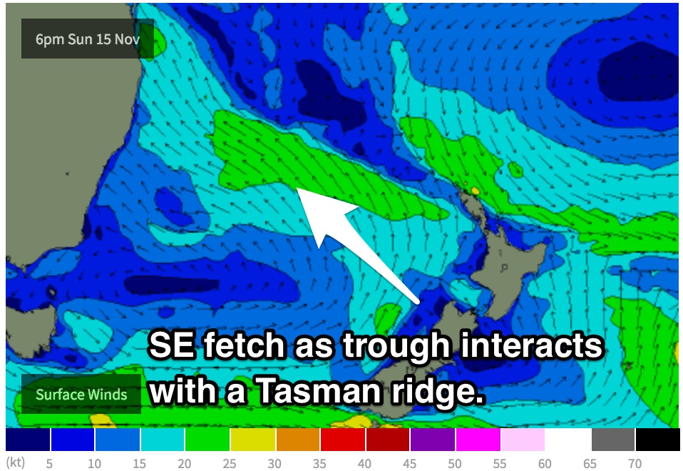
We will have to rely on short range energy on Sunday, with a mix of easterly and southerly windswell in the water. A trough will stretch over the Tasman Sea whilst interacting with a ridge over the South Pacific generating a southeasterly flow aimed towards QLD. Open beaches will pick up a dribble of easterly swell off this fetch, with small peaks in the 1-2ft range.
South facing beaches will offer a touch more size as they pick up the effects of a local southerly airflow. The Hunter Coast has the potential to highlight a small and inconsistent southerly groundswell generated by a frontal progression in the Southern Ocean today, however it’s impact will be subtle, occasional 2ft sets at best
This southerly airflow will limit options heavily, creating poor conditions at the beaches which are seeing any rideable size. Protected corners of open beaches will have the cleanest options, although likely undersized.
Next week (Monday 16th - Friday 20th):
 The aforementioned southeasterly fetch spanning the Tasman, although weak, will be fairly long lived. Therefore it’s impacts will be felt throughout Monday where open beaches will continue to see peaks in the 1-2ft range. Residual southerly energy will also keep south facing beaches in the 2ft range.
Southerly breezes will ease along and tend east/southeasterly all coasts as the day progresses. Obviously being onshore conditions aren’t going to be over special, however winds should be light enough for the surf to be workable on a board with plenty of volume.
The easterly swell will be at it’s peak on Tuesday providing open beaches with options in the 2ft range. Winds are expected to be light west/northwesterly for the early session, tending northerly and eventually increasing into the afternoon.
Options will be confined to northern corners as the day progresses, finding shelter from the breeze as they increase.
These northeasterly breezes will whip up a small amount of northeasterly windswell to the 2ft range by the afternoon at open beaches, fading to the 1-2ft range by Wednesday morning. A small amount of long range southerly groundswell will also be in the water generated by a poory aligned front which is set to move over the southern Tasman on Monday. Sideband energy is expect to provide inconsistent options in the 2ft range at the south swell magnets throughout the day.
Winds should have swung light/moderate northwesterly by Wednesday morning cleaning up the small swell that’s in the water.
This is the part where model disagreement comes in. Some models are picking a morning southerly change, whereas others are holding onto the moderate northwesterly breezes before an afternoon change.
There isn’t much point in deliberating over timing of a wind change and the resultant surf size, because the situation is likely to change one way or the other. We will keep an eye on the situation and give detail as it comes.
Looking further ahead, models are suggesting that a strong front will move over the nation’s southeast on Thursday, steering southeasterly gales through Bass Strait and up the coast of NSW.
If this scenario comes off (which it very well could - most models are indicating front in one form or another, varying strengths) we would be in for a large, short range southerly swell for the end of the week. More updates on Monday.
Comments
Looking fun in Newy this arvo