Options at most locations, NE winds causing a few issues

Sydney, Hunter and Illawarra Surf Forecast by Guy Dixon (issued Friday 16th October)
Best Days: Saturday, Monday morning, Tuesday morning (Hunter/northern corners) and Wednesday
Recap:
A fun east swell provided workable peaks in the 2ft+ range across open beaches yesterday, cleanest in the morning preceding the afternoon seabreeze. The Hunter collected a touch more size with an element of underlying south swell in the mix.
The surf is holding in a similar size range today, however persistent northeasterly breezes overnight made finding a clean wave an uphill battle. Furthermore the seabreeze came in particularly early creating soft bumpy conditions. The Hunter is handling these breezes much better with workable peaks in the 2ft+ range.
This weekend (Saturday 17th - Sunday 18th):
A local northerly fetch (discussed in Wednesday’s notes) developed off the coast of New South Wales throughout Thursday which has been generating winds of around 25-30kts. A second burst of north/northeasterly breezes in the 20-25kt range are likely to hug the coast throughout today, maintaining an element of northeasterly wind swell for the start of the weekend.
In conjunction with small background southerly groundswell, the surf should hold in the 2ft range for most locations throughout Saturday, slightly larger across the Hunter as the underlying southerly groundswell is highlighted.
The wind scenario is tricky for Saturday, but there should be windows of opportunity for a wave of variable quality throughout the day.
A southerly air flow with an initial wind change is likely to be established over the Illawarra and Sydney coasts by day break (south/southwesterly along the Illawarra). This breeze should have eased dramatically by mid-late morning, tending light easterly. Light onshore winds will persist throughout the afternoon preceding the true southerly change after dark. This change isn’t looking particularly strong however gusty southerlies are likely to whip up a short range southerly wind swell for Sunday.
Size wise, Sunday is not looking particularly interesting with south facing beaches picking up poor quality peaks in the 2-3ft range (more so into the afternoon). Open beaches will offer cleaner conditions, but will have to rely in remnant northeasterly energy which will be fairly weak by that stage.
Southeasterly breezes will dominate making it tricky to find a decent wave. Southern corners will be offering the cleanest, but smallest options.
Next week (Monday 19th onward):
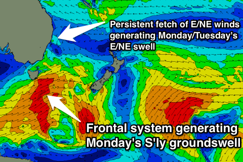 A strong frontal progression will move south of Tasmania and into the New South Wales swell window on Saturday evening steering a west/southwesterly fetch 40-45kt winds. As a result, a southerly groundswell is expected to move up the coast throughout Monday allowing the surf to build into the 3ft+ range at exposed south facing beaches, larger across the Hunter and more to 4ft.
Meanwhile, an easterly fetch over the South Pacific is still on track to move south further into our swell window. Breezes off the back side of this system are showing a more east/northeasterly direction which would favour swell generation for our part of the world.
A fun northeasterly swell off this system is also expected to fill in across open beaches on Monday afternoon/evening to 2ft, holding throughout Tuesday in the 2ft+ range. There should be options at most beaches for these two days, winds permitting.
Monday is looking at an onshore airflow all day, increasing in the afternoon however, these types of set ups can often offer a period of light variable winds during the very early session. At the very least, winds will be at their lightest at this time of the day. Breezes are only expected to freshen from the northeast later causing conditions to deteriorate.
Northerly breezes are likely to dominate along all coasts Tuesday morning, freshening from the northeast into the afternoon. Northern corners will be the best bet for most of the day.
This freshening northerly airflow on Tuesday will contribute to an increase in northeasterly energy, reaching 2-3ft at north-east facing beaches late in the day, peaking Wednesday morning more in the 3ft+ range, however the quality is a little dicey. Open beaches which will pick up this energy are likely to be wind affected and bumpy. Protected northern corners will be the best option.
Depending on the timing of an approaching change, winds have the potential to swing offshore leading to peaky A-frames along the open beaches for the afternoon session. At this stage, I’m leaning towards the favourable wind scenario, although we can only cross our fingers and wait for models to come into agreeance.
A fresh/strong southerly flow will dominate all coasts on Thursday in the wake of this change. A short range wind swell will increase to the 4-5ft range at exposed south facing beaches by the afternoon, however quality and periods will be low. Protected southern corners will be offering the cleanest conditions, but not much size will be filtering in.
Further ahead, we are looking small conditions with back ground energy dribbling in, generally from the southern swell windows. More to detail come next week.
Enjoy your weekend.
Comments
hey guy, you reckon northern corners will be the go for Monday arvo? Looks like the winds swinging NE quite early on..
Yep, if you can't make it for the morning session, I'd be considering northern corners as they will be picking up the most size off a southerly groundswell and they'll be offering the most protection from a northeasterly breeze.
thanks guy
Hi, the model doesn't seem to be picking up Monday's groundswell?
You're right. Models are under calling the southerly groundswell for Monday. Looking at the periods moving up the coast we're still looking at south facing beaches building to the 3ft+ range.
guy do you think we will see 3ft sets at dawn tomorrow? thx for the reports
South facing beaches should be in the 3ft range at dawn, if not shortly after.
Looks like the call was pretty good Guy, Bondi's picking up some 3ft sets.
+1 sensational call. Scored a ton of peaky ones on the northern beaches with a handful of guys. Inconsistent but when they rolled in they were fun!!