Peaky NE swell for the early sessions, more next week

Sydney, Hunter and Illawarra Surf Forecast by Guy Dixon (issued Wednesday 14th October)
Best Days: Saturday morning, Tuesday morning
Recap:
Despite building to the 2ft range yesterday off a southerly swell, there weren’t many options for a decent wave with peaky low quality surf under an onshore flow.
This morning brought a period of northwesterly breezes which allowed for semi-clean and workable peaks across Sydney and the Illawarra, however a seabreeze has since kicked in and we are now left with junky 1-2ft peaks, slightly larger across the Hunter.
This week (Thursday 15th - Friday 16th):
All swell windows look to remain fairly dormant in the short term with weak and insignificant background energy maintaining low quality surf in the 1-2ft range throughout Thursday.
A northeasterly airflow will setup along the coast throughout Thursday, increasing on Friday whipping up a dominant short range northeasterly wind swell. In conjunction with a small underlying southerly swell generated by weak and poorly aligned frontal activity, we should start to see a small increase in size late on Thursday afternoon to the 2ft range, slightly larger throughout Friday in the 2ft+ range.
Open beaches are likely to pick up the most size as the northeasterly wind swell dominates, however the same local north/northeasterly airflow which is whipping up the swell will also limit options to protected northern corners for most of each day.
If you’re keen to get wet, the mornings will offer the best conditions by far. Early northwesterly breezes are a good chance along the Sydney and Illawarra coasts on Thursday and Friday, while the Hunter is more likely to be under a northerly airflow each morning.
Take a thick summer board and adjust your expectations accordingly.
This weekend (Saturday 17th - Sunday 18th):
A southerly change is looking to move up the coast on Saturday, however two front running models have been disagreeing on the timing/strength of this change over the past few days. The latest model run has finally come more into line however.
It looks as though a north/northeasterly breeze will abate for a few hours on Saturday morning before increasing again in the afternoon. The true southerly change should then move through in the evening, whipping up a small southerly swell for Sunday.
During the period of slack winds on Saturday morning, residual 2ft swell out of the northeast will provide fun peaky surf for much of the coast. As for Sunday, the northeasterly element of the swell will gradually dissipate, while the aforementioned southerly groundswell will become more dominant.
Size wise, this combination of swell should provide 2ft peaks in the morning, with south facing beaches building to 2-3ft in the afternoon. Breezes are likely to prevail from the southeast for much of the day on Sunday making for ordinary surface conditions, gradually easing throughout the day.
Next week (Monday 19th onward):
There are a couple of interesting swell generating systems to consider over the coming week.
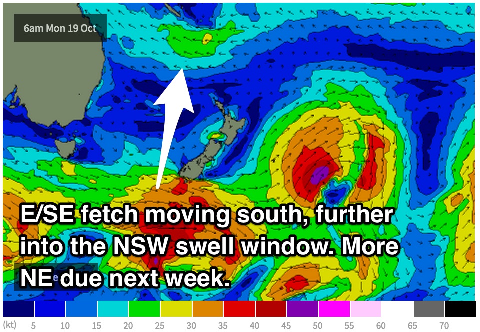
Firstly, a strong front will steer a broad fetch of west/southwesterly gales across our southern swell window providing a southerly groundswell for Monday. The surf should be in the 3ft range on Monday, bigger across the Hunter, with a secondary pulse off the back side of the low holding the surf at a similar sie for Tuesday morning, easing throughout the afternoon.
Monday has the chance of being light variable in the morning, with a light east/southeasterly breeze developing in the mid-late morning.
 A tropical depression located to the east of Fiji is expected to weaken and dissipate in the coming days, however the lingering trough will continue to steer an east south/easterly fetch over the tropical South Pacific.
This fetch is likely to intensify slightly on Friday which should send a pulse of northeasterly swell towards the NSW coast, due Tuesday. The swell off this system is expected to build into the 2ft range by the afternoon.
Breezes look to tend north/northwesterly on Tuesday morning across the Hunter, northwesterly elsewhere leading to fun conditions preceding a gusty northeasterly seabreeze.
Further ahead, models suggest that the trough driving the east/northeasterly fetch could drop south, further into our swell window. As a result, we wouldn’t have to rely on sideband energy and the coast of NSW could be graced with more fun northeasterly swell later in the week.
More detail to come in Friday’s notes.
Comments
Old mate racing a small inside shorey. Looks super fun though!