More south swell ahead: Tues and Thurs the pick

Sydney, Hunter and Illawarra Surf Forecast by Ben Matson (issued Monday 5th October)
Best Days: Tues: early light winds and easing leftover S'ly swell. Thurs/Fri: mix of S'ly swells and early light winds. Sat: small south swell with early light winds. Sun: new long period S'ly swell building during the day, with freshening N/NE winds tending NW late.
Recap: A strong S’ly groundswell pushed into the Sydney region on Saturday, slightly exceeding expectations with sets reported around 3ft+ at south facing beaches (against a forecast of 2-3ft), with bigger 4-5ft sets observed across the Hunter.
This swell had an interesting source: an intense low pressure system that passed south of Tasmania on Thursday, which ultimately displayed a W/SW fetch - aimed well and truly away from our coastline. As such, the actual size seen across the NSW coast was incredible given the enormous spread back to the coast that was required. The swell periods were still growing as the swell built along the NSW coast; the Gold Coast buoy ended up recording peak periods of 20 seconds (which is very impressive, and slightly higher than the theoretical periods suggested by the fetch).
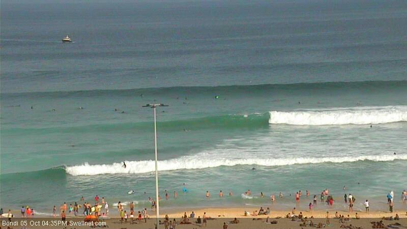
Nevertheless, this swell eased slowly throughout Sunday - still displaying 2-3ft sets at south facing beaches in the morning - ahead of a second S’ly groundswell that pushed through overnight, and has slowly built through this morning with sets now a solid 4ft at Sydney’s south facing beaches (see surfcam grab from Bondi, below), and bigger in the Hunter. Again, this is slightly bigger than expected (Friday's forecast estimated 2-3ft+ at south facing beaches).
Again, the source of this swell was a similarly poorly-aligned Southern Ocean low, aimed up into New Zealand and the South Pacific, but with core wind speeds of 50-60kts we’ve seen an amazing level of sideband energy spread back into the coast.
The best part of the weekend was that conditions remained clean for the entire duration thanks to dominant ridge of high pressure and mainly offshore winds from the western quadrant.
This week (Tuesday 6th – Friday 9th)
Today’s south swell will ease slowly through Tuesday.
Our wave model (via period charts) shows a small swell front moving up into the region during the morning, this is a secondary pulse from the same parent low that provided today’s swell (but is from a different part of the low - a strong southerly fetch at polar latitudes, wrapping into the low over the weekend).
Due to the wave model’s inability to resolve these small fluky long range swells, some locations aren’t seeing this energy in the graph/table (i.e. Northern Beaches forecast) however it is showing up at other locations (i.e. Ulladulla forecast, which is showing swell periods levelling out at 12 seconds into the afternoon).
Now, the wave model’s poor depiction of the weekend’s southerly swells means I’m not especially confident on the size forecast for Tuesday: I know the model is way off, but by how much?
Right now I think today’s south swell will probably ease to a very inconsistent 2-3ft across most south facing beaches (smaller elsewhere, but a little bigger in the Hunter) but I couldn’t rule out a few bigger sets into the afternoon as this next secondary swell peaks. It’s unlikely IMO, but if it does occur we’ll know where it came from.
In any case we’re looking at early light NW winds tending N’ly morning and freshening, before picking up from the NE into the afternoon. So unless you’ve got a sheltered northern corner that can handle the afternoon NE winds, aim for an early surf at a south swell magnet.
These NE winds will whip up a minor NE windswell for late Tues/early Wed but there won’t be much size in it. Easing southerly swell will continue through Wednesday morning with a brief period of freshening N/NW winds ahead of a gusty S’ly change that’s due into the South Coast before dawn, up into the Wollongong region around sunrise and the Sydney basin sometime early-mid morning, and a little later in the Hunter.
This southerly change will be linked in with an intense low passing south of Tasmania in the early hours of Wednesday morning that’ll generate a new southerly groundswell for Thursday. But prior to this, Wednesday’s gusty southerly change should whip up a low quality but punchy southerly windswell for the afternoon that should reach a solid 4ft at south facing beaches. Don’t expect much size away from open south facing beaches.
Thursday looks pretty fun at this stage. A weak ridge will linger across the coast in the wake of Wednesday’s change, so winds will be mainly onshore (light to moderate in strength) but there should be a period of light W/SW winds in a few regions at dawn. As for surf, Wednesday’s short range south swell will be easing rapidly but it’ll be replaced with small long period S’ly swell, with sets in the 3ft+ range at south facing beaches (very inconsistent at times). Again, the southerly direction will create much smaller surf at beaches not open to the south, however the Hunter should see a few bigger bombs.
A series of poorly aligned trailing fronts (behind the intense Southern Ocean low) will work on the pre-existing sea state generated by the low to maintain inconsistent southerly swell through Friday. At this stage I think we’re looking at slow, infrequent waves between 2ft and maybe 3ft at south swell magnets (bigger in the Hunter) but it’ll be much smaller everywhere else due to the direction. We may also see a small east swell off the ridge in the Tasman Sea but no great size is likely from it. Winds are expected to swing to the NE but there’ll be a period of NW winds early morning.
This weekend (Saturday 10th - Sunday 11th)
Sunday looks like the pick of the weekend at this stage.
Saturday is on track for a small level of residual south swell from the trailing fronts (mentioned above) with very inconsistent 2ft sets at south facing beaches, tiny surf elsewhere and freshening NE winds that may whip up a minor NE windswell for the afternoon. The Hunter should see some bigger waves but it’s likely to be very inconsistent.
On Sunday, we’re looking at the arrival of another long period south swell from a similar synoptic development as per what generated our most recent south swells.
An intensifying low pressure system south of Tasmania on Thursday night is expected to briefly push up through our acute south swell window, and the resulting long period energy is expected to nose into the coast on Sunday morning, building size across the region throughout the day. At this stage we are on track for late afternoon sets in the 3ft to maybe 4ft range at south swell magnets (bigger in the Hunter) and freshening N/NE winds are likely ahead of a late W’ly change.
We may also see a small level of NE windswell in the mix, but the primary target for Sunday will be sheltered northern corners that both pick up south swells and offer protection from these winds. With some luck the W’ly change will be shunted forward in future model updates.
Next week (Monday 12 onwards)
The longer term trend maintains a similar pattern of deep sub tropical lows migrating through the Southern Ocean, providing intermittent southerly swell events to the coastline throughout much of next week. More on this in Wednesday’s update.
Comments
Forecast notes up now: sorry for the delay (always difficult on public holidays!).
Just some feedback Ben, Saturday was as predicted in the Illawarra with waves up to head high with long breaks between. Winds were light N/E in the arvo. Sunday started off small but jumped again to chest high then eased into the arvo with the dropping tide.Winds were offshore & light all day. Monday, the swell jumped again , very intermittent to chest high, winds light & variable.Perfect score card Ben, keep up the good work. Hope you scored waves too. A top weekend that'll go down as a classic . Cheers!
yeah likewise as usual the forecast notes from Guy and Ben were bang on. It just makes me wonder what the point of the computer generated models are sometimes if they can't be manually adjusted when they are obviously completely off?
No complaints even though the consistency was highly variable. I surfed Saturday, Sunday and Monday. Saturday on the mid north Coast was the most consistent but Sunday and Monday on the NB it was really about picking your moment. It would pump for half an hour, drop back for a while, then pump again. Lots of frustrated crew at times, heaps of drop ins, lots of wasted waves, standard ranging from low to totally incompetent.......but local knowledge is a wonderful thing!
"It just makes me wonder what the point of the computer generated models are sometimes if they can't be manually adjusted when they are obviously completely off?"
It's a really good question. And I'd like to try to explain it by way of an article, as I can't sum it all up in a couple of sentences.
But in short: Swellnet is a business, of which it was unsustainable for our old graphical forecast products (i.e. swell graphs) to be manually generated by a qualified surf forecaster. The classic example of this was Mondays, when the forecast graph on the site had been prepared three days earlier. A LOT can happen in three days (heck, a lot can happen in 12 hours!) so we were always under the pump on Mondays to refresh things.
We did this for the first ten years, but it became apparent early in the game that we needed to find an automated solution. So, we spent five years developing something we felt comfortable with.
I now think we've got the best automated surf forecasting system in the world, but it's only as good as the input source data: our surf forecasts rely on wave model data, which we run in-house but utlimately have no control over the actual algorithms (neither does anyone else - hence why all of the other surf forecasting websites with automated data didn't "show" these S'ly swell events either).
Finding a solution is extremely hard. The models update 4 times per day, so a "manual QC" is extremelty difficult when you've got a minimum of 64 data points per location (4 data points per day x 16 days), and 130 Australia forecast locations. Times this by the four daily updates, and you're at 33,280 data points per day for Australia to be QC'd.
And that's just one parameter: surf height. If we need to QC individual swell trains, then that'd double, if not triple the number of data points, plus we'd also have to QC wind at the same time (so, another 33K data points per day - actually, double that - direction and strength are two individual parameters).
And, we're rolling out hourly forecasts soon, so the number of data points will multiply by six.
So, it's easy to see how difficult it is to build a nation-wide QC'd surf forecast system, when Swellnet is a very small team limited resources.
In the meantime our detailed foeecast notes should certainly suffice! But we do have some ideas about how we can improve things and are working on them in the background.
thanks for the detailed explanation Ben. I have a lot of respect for you and what you've done with this site, my point was that these forecast notes are highly accurate, whereas the automated models I have learnt to take with a grain of salt.
An average looking low (direction wise anyway) that delivered a whole lot of goodness.
Any idea when or if the Batemans and Eden bouys will be back on line? as they are really useful for those swells.
No complaints from me. I come from a time when your surf report came from Bob Evans & that was what it was like on that day .As for the future you prayed to Huey for swell or got really hammered the night before & you'd wake up to good waves & a massive hangover. I enjoy the forecasters notes & have learned a lot. Thank you Ben & Guy.
The S'ly change hit just before dawn in Sydney, and it's smashing the coast with gale force winds. Newcastle still looks serene and peaceful.. won't be that way for much longer though.
any decent waves around cronulla? really desperate to go surf
oh dear, son of Sorrento......
You may find an answer here - http://www.swellnet.com/surfcams/cronulla-beaches