Complex period ahead with lots of great waves

Sydney, Hunter and Illawarra Surf Forecast by Ben Matson (issued Monday 31st August)
Best Days: Most days should have good waves, Tues the biggest.
Recap: Friday’s south swell eased through Saturday but remained strong through the morning, and conditions remained clean with offshore winds. A strong new S’ly swell build across the coast on Sunday, and early offshore winds swung S’ly late morning, deteriorating conditions at exposed beaches. However south facing locations reached 6ft+ late afternoon with bigger waves in the Hunter. This south swell has held into this morning, with set waves in excess of 6ft+ at south facing beaches. The early period of W/SW winds tipped just for a few locations actually occurred just about everywhere (somewhat improving conditions from Sunday’s southerlies)
This week (Sep 1 - 4)
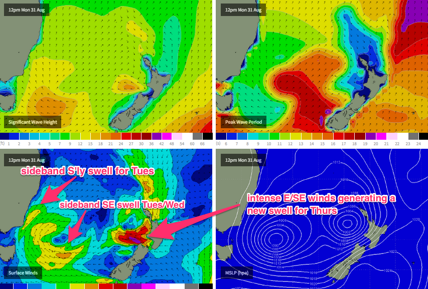
The weather charts are very complex for the entire eastern seaboard. See the chart below for an example.
Our current south swell was generated by a strong front that wrapped around a broad, multi-centered low pressure system that has occupied the Tasman Sea since late last week (and is related to the ECL that delivered a strong SE swell to most regions).
Over the coming days, we need to consider how much residual swell will maintain from the existing southerly event (being supplemented by a strong SW fetch off the South Coast), plus several sources of new swell - some SE swell on Tuesday from the parent low in the Far Southern Tasman Sea, plus a brief pulse of E/SE groundswell on Thursday from a temporarily intense secondary low that’s currently developing west of Cook Strait (the body of water separating New Zealand’s North and South Islands).
As such, it’s hard to ascertain just how much size we’ll see from each source. Today’s south swell will ease considerably but the SE swell due Tuesday should maintain 4-6ft surf at most south facing beaches, with bigger bombs in the Hunter. Surf size will be smaller at locations not completely open to the south, but in contrast to the current swell event there probably won’t be quite the same dramatic size difference between exposed and protected locations.
Tuesday’s conditions are looking very good too, as local winds will swing to the W/SW across most regions for much of the day, with a chance for a weak sea breeze in the afternoon.
On Wednesday, both the S'ly and SE swells will ease back in size, possibly some early 4-6ft sets at exposed south facing beaches (mainly in the Hunter) but becoming smaller during the day, down to 3-4ft by the afternoon. Light offshore winds are expected all morning ahead of a freshening NE breeze in the afternoon, related to an impending low pressure system modelled to form off the NSW coast on Thursday. So, make the most of the early surf on Wednesday.
Thursday looks very tricky. First of all, we’ll have a new E/SE swell in the water, which I referred to in Friday’s notes as being ‘sneaky’. The reason for this is that the synoptic chart is quite busy at the moment, and at a quick glance, the primary low in the Southern Tasman Sea is the focus of everyone’s attention. However a small low west of Cook Strait is expected to become supercharged this evening from an indeed of tropical moisture from the north, resulting in 45-50kt winds for a brief period into the early hours of Tuesday morning - and it's easy for this to slip under the radar (especially as the swell models don't seem to be picking it up very well).
This should set up a brief pulse of E/SE swell that’s due to the arrive in the early hours of Thursday morning, producing inconsistent sets in the 3ft+ range. It’s certainly not a high confidence event but with the previous SE and S’ly swells easing considerably by Thursday, this event will be the primary energy in the water.
However winds look a little funky on Thursday, as an upper trough crosses the coast and a new surface low forms off the Southern NSW coast. We’re likely to see a small level of NE swell in the water from overnight winds - size is as yet unsure - and the general trend will be for some form of N'ly wind early morning to swing NW, then W’ly, then S’ly.
When this transition takes place is as yet to be resolved. Some models have the S’ly change into the South Coast mid morning and then early afternoon across Sydney, whilst other models have a later change. If the S’ly change arrives in the morning, we’ll see a strong late increase in new south swell but if it’s later, then the south swell will kick in on Friday. I’ll have a better idea of this on Wednesday, but there's certainly a good chance for a window of fun waves at some point on Thursday.
This new surface low is expected to be a Tasman Low, and not an ECL (mainly due to its rapid eastward track) and as a result Friday looks like it’ll finish the week with gusty southerly winds and a large southerly swell, with sets in the 5-6ft+ range at south facing beaches.
This weekend (Sep 5 - 6)
Friday’s large S’ly swell is expected to ease through Saturday, but it’ll be supplemented by a new long range S’ly swell originating form a polar front moving through the Southern Ocean (and up into the Tasman Sea) later this week. Based on the latest wind forecasts we should see a peak somewhere in the 4-5ft range at south facing beaches, with a few bigger bombs in the Hunter.
This swell is expected to build Saturday and then slowly easing Sunday, however early indications are that Sunday will have the best winds (light and variable) thanks to a lingering S’ly flow across Southern NSW on Saturday. At this stage it’s likely that the early morning will see a period of light offshore winds, but Sunday still looks the pick as we’ll see the swell maturing by this time along with a more prolonged stint of favourable conditions. Let’s see how Wednesday’s model runs are stacking up.
Comments
Hot diggity dog, that's a good looking fetch west of Cook Strait. Amazed the swell models aren't picking up much from this event.
Wow! This one is even better, from this morning. Solid band of 50kt winds (interesting the direction tweaked E/NE just off the NW tip of the South Island).
Good ol Cook straight.
A great weather funnel that one.
Its taken a few marine lives over the years.