Great week of waves ahead

Sydney, Hunter and Illawarra Surf Forecast by Ben Matson (issued Monday 4th May)
Best Days: Tues: easing E/NE swell with good winds. Wed: new pulse of E/NE swell with good winds. Thurs: easing E'ly swell and a small S'ly swell. Fri: small E'ly swell and a building, strong S'ly swell. Sat/Sun/Mon: strong S'ly swell.
Recap: Strong building E/NE swell all weekend with dicey winds on Saturday (mainly onshore) tending moderate to fresh S/SW on Sunday. Wave heights seemed to peak around 4-5ft but larger 6ft sets were observed on the South Coast. Easing but much cleaner surf this morning as the swell throttled back.
Next week (May 5 - 8)
Lots of swell on tap this week with generally good conditions too.
Although the trough and low responsible for the weekend’s surf has dissipated, there’s still a healthy infeed of NE winds stretching back into the South Pacific. This was always visible in last week’s model guidance but the last few runs have strengthened the fetch so we’re looking at bigger surf through the middle of the week than was previously expected from this source. It’s also worth noting that our swell model is not quite picking up these developments particularly well (it has the period, but not much size).
Nevertheless, wave heights are expected to ease back a little on Tuesday but should maintain 2-3ft+ sets across most open beaches, and overnight variable winds are expected to swing NW and freshen so conditions should be nice and clean on the surface. The fetch generating this swell is aimed a little better towards the South Coast so bigger waves are likely south from the Illawarra. However as it’ll be the backside of the weekend’s pulse it may be a little inconsistent at times (expect smaller waves at south facing beaches too).
On Wednesday, a new pulse of E/NE energy from the strengthening mentioned above is expected push through. It probably won’t quite be there early morning, but by mid-morning we should be seeing distinct lines with set waves expected to push back up into the 3-4ft range at most open NE facing beaches through into the afternoon. A cold front will cross the South Coast during the early hours of the morning, bringing moderate to fresh W/SW winds but they’ll be favourable at most locations. Again, this entire system will be slightly better aimed at points south of Sydney/Illawarra so there’s a reasonable chance we’ll see bigger waves on the South Coast on Wednesday afternoon. However south facing beaches and the northern Hunter will be smaller.
The fetch generating this swell will slowly ease through the middle of the week but will still remain active, so we’re looking at a gradual drop in size through Thursday (2-3ft, bigger down south) and then Friday (2ft, bigger down south, becoming smaller throughout the day) but probably more prominent will be the decrease in consistency. Winds look great for Thursday and Friday too, freshening W’ly tending W/SW, even SW in the south of the state as a series of vigorous fronts lash the bottom of the country.
Unfortunately, last week’s forecasts had suggested we’d see a bigger pulse of E’ly swell around Friday, but the source of this - a tropical disturbance near New Caledonia, embedded in a strengthening trade flow - has been re-routed in the last few model runs. Instead, we’ve got the strengthening NE fetch above (responsible for the Wed/Thurs pulse), and there’ll be some other mid-week developments near Vanuatu (that won’t benefit us at all). It’s a shame that the Friday's swell won’t eventuate as the models were pretty consistent for quite a few days last week, but that’s the way things go with long range outlooks.
But that’s not it for the short term forecast. Last week's notes also mentioned a strong frontal pattern and an associated round of south swells for the state. The latest model guidance has actually (slightly) strengthened these fronts but also pushed them a little further north, and this has impacted our swell potential.
First off - the swell initially due Wednesday (from a gale force fetch exiting eastern Bass Strait on Tuesday) has been downgraded. Not due to the strength of the winds - they’re actually stronger - but because the alignment the fetch now looks like it’ll be W/NW tending straight W’ly. In order to see anything appreciable from this swell window we need at least a few degrees of south in the direction, preferably W/SW as a minimum, and ideally SW.
The pattern has also been pushed back half a day to a day, meaning we won’t see any south swell until very late Wednesday, more likely Thursday morning. At this stage it’ll probably amount to some inconsistent 2ft+ sets at exposed south swell magnets, but the dominant swell will probably be out of the east. I'm keeping my expectations low from this southerly swell at this stage.
A much stronger, broader frontal progression across Tasmanian longitudes is then expected through Wednesday, Thursday and Friday, and the fetch alignment should swing more W/SW (across Bass Strait latitudes) and SW (in the Southern Ocean). This is expected to generate a stronger southerly groundswell for Friday that’ll nicely replace the easing E/NE swell. Wave heights are expected to build all day from a small start, and should reach 4-5ft+ at south facing beaches into the late afternoon, with some bigger bombs at offshore reefs and in the Hunter. With moderate W’ly winds on hand there should be some great waves to finish the working week.
I’ll fine tune the specifics in Wednesday’s outlook - there’s even a chance for an upgrade in the size of this south swell too if the fetch alignment veers slightly anticlockwise.
This weekend (May 9 - 10)
It’s south-swell-o-rama for the weekend. What’s most impressive is that all of the associated fronts will be working in conjunction with a large, stationary polar low sitting directly south of the Tasman Sea, but just off the ice shelf. So this means that the swell window - albeit our most acute southerly window - will remain active for five or six consecutive days.
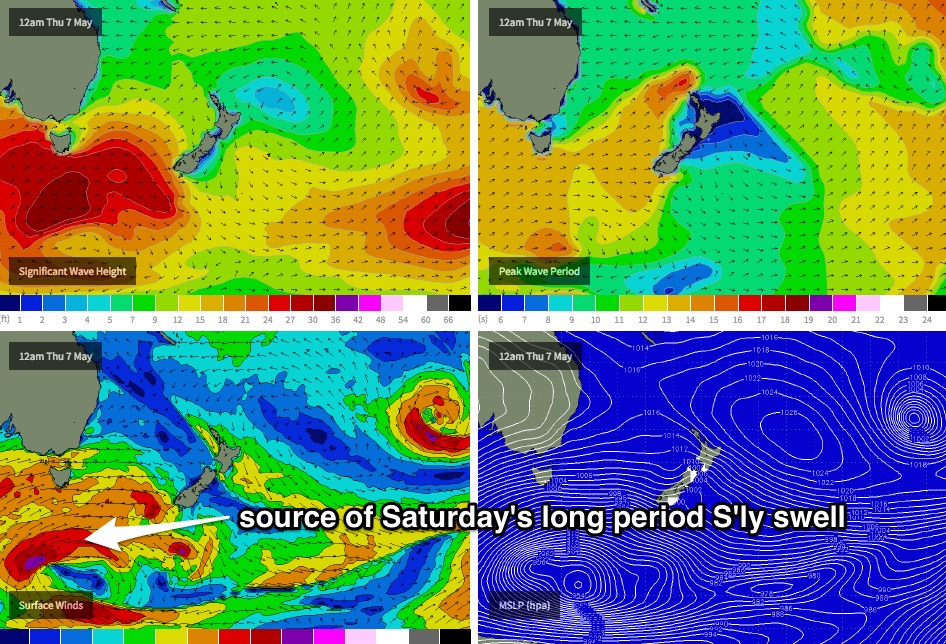
Friday’s strong southerly swell is expected to be overrun by a few new rounds of energy over the weekend - a long range pulse on Saturday (with peak swell periods near 18 seconds, see source via image below), followed by a second mid-range pulse on Sunday. In general, south facing beaches should hold the 4-5ft range both days however these sustained long period groundswells often produce wave heights far above this at selected swell magnets (i.e. quite a few spots across the Hunter) and offshore reefs and bommies. Again, I’ll fine tune the specifics on this on Wednesday.
Also in the mix over the weekend will be a small residual E/NE swell from some sustained trade activity way out in the South Pacific. It won’t amount to much but will otherwise keep NE facing beaches flush with some small long lines.
As for local conditions, it’s looking very wintery with moderate westerly winds that may even veer more W/NW into Sunday. All in all, there should be plenty of options to pick and choose from.
Next week (May 11 onwards)
More south swell! The frontal progression across Tasmania looks like it’ll continue through the weekend which means more strong southerly energy for the first half of next week. By this time our east and north-east swell windows will be all quiet, so our focus can 100% switch to the Southern Ocean. And at this stage there’s certainly a chance for some sizeable waves from the south throughout the week. More on this on Wednesday.
Comments
small today in the city beaches compared to yesty. i was hoping the swell would have a bit more in it. if Sun was 6ft, or even 4ft then today was about 1ft.
yeah agreed, swell died in the ass - and wind was NE to top it off
What time yesterday though? And at what beach? Was really good in the morning.
thanks Ben - knocked off work early - so wasn't out till mid-afternoon in the gong - definitely missed the best of it!
Yesterday morning at Maroubra... 2ft to 4ft but unfortunately bad alignment resulting in mostly closeouts. This morning there was barely a 1 foot wave to be had by 8AM.
But with a full moon on one side, a sunrise on the other and a curious pod of dolphins in the water, who could complain! :)