Sunday and Monday looking fun

Sydney, Hunter and Illawarra Surf Forecast by Ben Matson (issued Friday 5th December)
Best Days: Sunday/Monday: building NE swell with an underlying E/NE swell. Pick your windows of good winds. Wednesday onwards: something's gonna happen in the Tasman!
Recap: Wave heights came in a little under forecast Thursday and Friday, with slow 2ft+ sets reported around the traps both days (but some locations coming in smaller than this). Winds have been generally moderate from the N/NE, lighter and more variable early mornings.
This weekend (Dec 6th-7th)
The charts are looking even more complex for the weekend. In fact there’s still a reasonable level of disagreement across the board, despite the fact that we’re so close to the event.
A broad, slow moving trough across the region is expected to muscle up over the weekend as a southerly change moves along the coast later today. Initially, winds won’t be too strong but as a strengthening high pressure system well SW of Tasmania moves eastwards, the pressure gradient between the trough and the high will firm up, and we may even see a small closed low form off the Illawarra coast.
In Wednesday’s notes I mentioned that we could see freshening SE winds south of Ulladulla on Saturday, but they now look like being a little stronger and may have some influence a little further north (i.e. Wollongong, maybe even Sydney in the morning).
The tricky part of this equation is how close the low comes to the mainland, because we’re likely to see an outflow to the north of the trough’s axis - which will probably be somewhere between Wollongong and Sydney after lunchtime. Before lunch, we’ll see an infeed of freshening NE winds to the north of this axeis too (ie across Sydney/Hunter beaches).
But, the low - if it develops - is then modelled to track south during the afternoon and in doing so will swing winds to the SW across locations further north (which could be Sydney by late in the day).
So overall, confidence is very low on the wind forecast for Saturday - I hate fence sitting, but honestly, anything is possible tomorrow.
As for Saturday’s swell prospects, there’s not much - just a similar level of weak NE windswell as per what we’ve seen for the last few days (1-2ft+). The freshening SE winds will generate some low quality windswell but not until the afternoon, and conditions generally won’t be good at these spots either (if you’re lucky, a handful of beaches in the Sydney/Illawarra region might pick up both the NE and SE windswells, and then see a late SW wind trend.. wouldn’t that be nice? Don’t get your hopes up though).
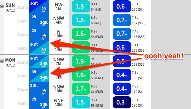
Sunday actually looks pretty fun at this stage. I’m only expecting small levels of short range SE swell across Sydney and Illawarra beaches (with bigger surf on the South Coast) but of more interest is a building NE swell expected to develop as a result of a strengthening N/NE fetch off the Mid North Coast on Saturday. Our surf forecast model is aiming for 3ft sets at NE facing beaches by the end of the day and I reckon this number is pretty good right now (note: smaller surf is likely in the northern Hunter due to the coastal alignment).
And in the mix there’ll also be a smaller mid-range E/NE swell from a strengthening belt of trades south of New Caledonia at the moment. It’ll sit underneath the NE windswell but should help increase the overall consistency.
Furthermore, we’ll be back into an unstable troughy atmosphere again, so variable winds are a good chance at some point, although freshening NE’ers are likely through the afternoon. As always, keep an eye out for thunderstorms as they’re usually conducive to a short period of offshore winds (and therefore rapidly improved waves).
So the take-home mesage for Sunday: anticipate slightly smaller but cleaner waves early morning, with bigger sets pushing through in the afternoon as the NE wind also picks up. South facing beaches such as Bondi and Cronulla also won't see much of this NE swell very well either, so keep that in mind when choosing your destination.
Next week (Dec 8th onwards)
Sunday’s building NE swell (in addition to the underlying E/NE trade swell) looks like it’ll reach a peak on Monday, thanks to the N/NE fetch off the Mid North Coast reaching maximum intensity late in the weekend.
We should see set waves upwards of 3ft at most NE facing beaches on Monday (except the northern Hunter, and south facing beaches), and in fact NE swell magnets could see bombs in the 4ft range. Variable winds are expected all day ahead of a late shallow southerly change, although the model guidance isn’t very strong right now so the timing and confidence on this isn’t high.
From Tuesday we’ll see easing NE swells and unstable, variable conditions again as the lingering trough continues to dominate our local weather.
There are a lot of complex possibilities through the middle of next week, including a southerly change or possibly even the formation of a Tasman Low - but right now it’s all too speculative to have any degree of confidence in.
Either way I’m very confident that we’ll see some very good surf mid-late next week originating from nearby sources (i.e. the Tasman Sea, rather than the Southern Ocean or the South Pacific). Let’s take a closer look on Monday and estimate which days are best for flexitime.
Comments
monday lookin solid
seabreeze is all at sea with the winds but SN models pretty accurate with that NW. its uncrowded and cooking.
So nice to see a decent NE swell again!
I agree, so good to surf some breaks that haven't broken properly for ages, it felt like novelty...ha