Mix of swells from the southern quadrant

Sydney, Hunter and Illawarra Surf Forecast by Ben Matson (issued Monday 21st June)
Best Days: Tues/Wed/Thurs/Fri: initially an easing E/SE swell, mixed in with periodic fun small south swells with light winds. Biggest time frames look to be early Tues, Wed lunch/arvo and all day Fri.
Recap: Friday’s wave heights kicked prominently right on dark across the Sydney coast, preceding a weekend of large windy surf. How big did it get? Look no further than today’s WOTD for a good example of an offshore bommie just south of Sydney on Saturday (although this is an outlier, compared to the rest of the coast).
Saturday was quite unique in that it offered an incredibly wide range in wave heights owing to the acute southerly swell direction. Whilst many south facing beaches held out in the 10ft+ range, some protected locations - for example South Steyne - were significantly smaller by comparison, perhaps 2-3ft. However from my vantage point, early Sunday morning saw slightly bigger, more defined waves across the Northern Beaches as a fresh pulse of S/SE swell filled in across the region, generated by a secondary front that pushed up from more southerly latitudes later Friday and into Saturday. This minor swing in the swell direction provided a little more size across protected spots than on Saturday. However the swell peaked early in the day and dropped rapidly after lunch. Winds were generally fresh and gusty SW all weekend, veering to the south both afternoons but offering pockets of early W/SW winds.
This morning saw easing S/SE swell across the region with early light offshore winds. Interestingly, a new E/SE swell arrived at the coast around lunchtime, and has provided a noticeable kick in size this afternoon, with 3-4ft waves on offer at exposed beaches. Annoyingly for me, I mentioned this swell in last Wednesday’s notes but excluded it on Friday because the models had downgraded the responsible low, and I assume that any energy from this system would not be noticeable underneath the easing S/SE swell.. which was wrong! Interestingly, even assessing the ASCAT passes from Saturday (when the low reached maturity) doesn’t signify anything major.. the fetch was short lived, was working on a relatively benign ocean state, and it was off-axis from our swell window for the most part. An interesting Monday afternoon curveball indeed.
So with that.. on to this week’s surf forecast.
This week (July 22-25)
I’ve had a lot of fun analysing these complex systems in the Tasman over the last few weeks, but unfortunately our swell window has dried up and we’re looking at a lengthy period of small flukey swells, mainly from the southern quadrant.
Our current E/SE swell is expected to ease overnight but I wouldn’t be surprised if we see a few rogue 2-3ft sets at exposed beaches early Tuesday morning, ahead of an easing trend during the day. Winds should remain light all day so conditions should be quite good on top.
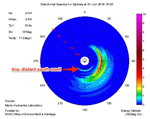
There’ll also be some distant southerly groundswell in the mix, from a deep polar low that traversed the Southern Ocean south of the continent late last week (and generated good waves for Vic/SA/Tas this morning). However we won’t see much more than a couple of feet at exposed south swell magnets, with bigger - but very inconsistent - bombs in the Hunter. In fact the Sydney buoy has already picked up the leading edge of this swell (Tp 19 seconds), which is shown neatly on the spectral plot below (as a side note, interestingly it’s not showing on the Tp graph on the MHL site).
Another front racing up through the lower Tasman Sea today is generating some sideband S/SE energy that’ll maintain small inconsistent waves at south facing beaches through Wednesday. At this stage I don’t think we’ll see much more than an occasional 2ft sets at most south facing beaches, but the Hunter often does quite well with these swells so larger 2-3ft waves are certainly possible here. Again, light winds are expected in all areas so conditions should remain pretty good. And surf size will be smaller at beaches with less southerly exposure.
The rest of the week continues this theme of small, inconsistent south swells with light winds. So, if you find somewhere working well over the next few days, dial it in for Thursday and Friday too.
Friday will probably see the biggest waves of the second half of the week thanks to a strong polar low developing well to the south of Tasmania on Tuesday, which is expected to send long period energy (Tp 16-17 seconds) into the South Coast overnight on Thursday before reaching most beaches Friday morning. At this stage current expectations are for occasional 2-3ft sets at south facing beaches, reaching 3-4ft in the Hunter - but it’ll be tiny elsewhere due to the swell direction. I’ll take a closer look at this on Wednesday.
This weekend (July 26-27)
I’m expecting more of the same small, flukey south swell to persist all weekend across the southern NSW coast.
The only other notable feature for the weekend is a broad surface trough that’s currently expected to push across from Victoria and out into the Tasman Sea during Saturday, and subsequently develop a modest S/SW fetch parallel to the South Coast.
This may in turn generate a small to moderate short range south swell for Sunday - but confidence is not high on any quality (or size) at this early stage. Let’s assess the data more comprehensively on Wednesday.
Longer term (July 28 onwards)
Nothing of major interest lighting up the long range charts at the moment, mainly due to an amplifying Long Wave Trough to the SW of Western Australia. Because the downward flank of this upper level system will be positioned across the eastern half of Australia's longitudes, the storm track will be focused away from our southern swell window. This suggests we could be looking at an extended period of small and/or flukey, short lived swell events for the next couple of weeks. So, get your small wave quiver ready to go, as it’s gonna get a lot of attention in the next little while.