Windy weekend of waves, with great surf for the longer term

Sydney, Hunter and Illawarra Surf Forecast by Ben Matson (issued Friday 6th June)
Best Days: Saturday: brief options working around local winds (probably in the a'noon). Mon: early period of good winds with a building S'ly tending S/SE swell. Wed/Thurs: fun SE swell with good winds. Fri: strong building E/SE swell with good winds.
Recap: Small south swell Thursday with mainly light winds tending onshore during the afternoon. Tiny conditions (and poor weather) this morning with strengthening southerlies and a building short range south swell throughout the day.
This weekend (June 7-8)
No major changes for the weekend. The current building short range south swell should hang around into Saturday morning, before easing a little throughout the day. Winds are expected to be fresh southerly throughout most of the morning, however similar to today we should see an early SW flow across small regions of the coast (i.e. Northern Beaches). A small E’ly tradeswell will also be present in the mix but may be hard to detect amongst the short range southerly noise. Exposed south facing beaches should have 2-3ft sets and it’ll be smaller elsewhere. Expect slightly bigger waves in the Hunter.
Of more interest is the likelihood that local winds will throttle back after lunch, and possibly swing to the SW during the afternoon, courtesy of a small low forming east of Bass Strait, deep within a broad trough stretching right along the East Coast. It may not massively improve surface conditions however it should be better than what’s on offer throughout the morning (except for those locations lucky enough to see morning sou’westers, that is). Just keep in mind the likely easing trend throughout the afternoon though.
By Sunday morning, a gusty southerly change associated with the small low mentioned above will have pushed across the region, delivering strong winds and building a solid short range swell for south facing beaches (should be 4-5ft+ at south facing beaches by the afternoon, smaller elsewhere). However the wind will really create some problems at most beaches so you’ll have to dive into a sheltered corner for the best conditions. Again, a couple of locations (i.e. Northern Beaches) may pick up a brief period of early SW winds however this will coincide with a temporary slump in wave heights. Either way, it’ll be quite blowy and the wind chill factor will be significant thanks to the cold air temps and steady rainfall, so keep your expectations low.
Next week (June 9-13)
Monday morning has some really good potential for the region. A secondary low pressure centre forming within the broad trough along the coast - well east of Bass Strait on Sunday - is expected to drive up into the region by Monday morning, bringing a solid S’ly tending S/SE swell to the region.
However, in similarity to the synoptic pattern expected on Saturday afternoon, we should see an early period of W/SW winds across the Sydney, Hunter and Illawarra regions which should favour much cleaner conditions for at least a few hours in the morning. This should also be around the same time the swell starts to lift, so at this stage there’s a reasonable chance for some lumpy but fun, sizeable waves before lunchtime. At this stage I think we’ll see solid 4-5ft+ sets at south facing beaches: this morning’s model data suggested slightly bigger waves but the latest 00Z GFS run came through a short time ago, and it’s pinched off the latter stages of the primary fetch, so I’m slightly lowering my expectations. I also think we’ll see a slight easing trend into the afternoon.
Tuesday looks pretty average at this stage with a ridge building across the coast that’ll probably focus onshore winds across the region with a moderate mix of fading S/SE and building short range E/SE swell (conditions should improve in the south though, where we’ll see lighter winds and improving conditions).
From Wednesday onwards we’re looking at much better conditions as a high pressure system continues to build across the region, and a broad through of low pressure centred over New Zealand is expected to generate some fun mid-range SE and E/SE swell for the region. Right now I think our model is under calling wave heights from this source; we’re probably looking at fun 3ft+ surf at open beaches building throughout Wednesday and holding into Thursday and possibly even Friday morning, with generally favourable conditions in most areas. Should be pretty fun in most areas.
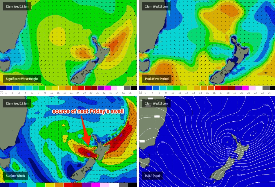
Of more importance for the longer term is a strong E’ly fetch - see chart below - that’s expected to spin up in the waters immediately west of Cook Strait (the body of water separating New Zealand’s North and South Islands) mid-week, as a broad, dynamic trough takes hold of New Zealand's North Island (creating some pretty damaging weather over there too!). This system is expected to generate a strong E/SE swell for Friday - probably arriving mid-late morning, peaking late in the day in the 4-6ft range. With light offshore winds currently expected for the region, next Friday could be very well worth some flexi-time. Let’s firm up the specifics in more detail on Monday.
Longer term (June 14 onwards)
Friday’s strong E/SE swell should persist into Saturday but will probably ease steadily throughout the weekend. Otherwise there are no other significant source of swell for the longer period currently showing on the radar.