Small patchy options for the next week and a half

Sydney, Hunter and Illawarra Surf Forecast by Ben Matson (issued Wednesday 28th May)
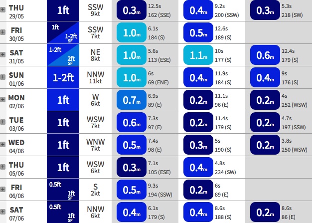
Best Days: Fri: small distant south swell. Sun: small NE swell.
Recap: Strong but easing S’ly swell Tuesday with early light N’ly winds tending fresh N/NE during the day. Smaller mix of rapidly fading S’ly swell and local NE windswell this morning, with freshening NW winds.
This week (May 27-30)
No major changes for the rest of the week. Small residual swells are expected on Thursday with early offshore winds expected to swing moderate southerly in association with a shallow change. There won’t be any major swell increase from this system - just a possible small afternoon bump in windswell at best.
However the Far South Coast may pick up some small late lines out of the south, originating from a distant groundswell that’s was generated off the ice shelf on Monday. A polar low of mainly moderate strength formed well south of the Tasman Sea, and a broad S/SW fetch (25-30kts) has pushed (and is still pushing) up into our southern swell window.
Due to the mediocre strength of the fetch and the large travel distance, the resulting swell won’t be very strong nor very large but we should see a reasonable push in size into Friday across most south facing beaches, with sets in the 2-3ft range (possibly a few bigger waves in the Hunter). It’ll be much smaller elsewhere due to the swell direction, and conditions should be OK with mainly light to moderate SW winds tending S’ly then SE during the day (or even tending variable).
This weekend (May 31 - June 1)
Not much surf is expected over the weekend. Friday’s small south swell will probably ease slowly into Saturday morning and further throughout the day, to be all but gone by Sunday. A small ridge building across the central Tasman Sea may whip up a foot (or possibly even two) of low quality short range energy for open beaches north of Wollongong both days if we're lucky, and a developing trough along the coast on Saturday will strengthen NE winds about the coastal margin that may kick up a small peaky windswell for Sunday (and possibly an infeed of E/NE energy as well).
However no major quality is expected from either source and conditions will be variable - if anything Sunday is probably the pick of the forecast period with the small NE surf and an overall N/NW tending W/NW flow in the wind but I’ll reevaluate this in more detail on Friday. Don't expect much more than a couple of feet at best.
It’s worth pointing out that the South Coast (and more so the Far South) will pick up more size (on Sunday) from this NE fetch due to it being located further downstream, but remember - we’re only talking about a short range windswell. So don’t plan a road trip for this one.
Long term (June 2 onwards)
Nothing of any major interest on the cards, all thanks to a dirty great big blocking pattern across the Tasman Sea.
However what’s interesting about this particular blocking pattern is its shape and alignment. The block is angled across the broader Australian continent, in a NW/SE orientation down to the South Island of New Zealand. What this means is that - unlike a more ‘zonal’ block across the Tasman - most of the synoptic activity in the South West Pacific is aimed up into equatorial regions (ie SE in direction) which doesn’t benefit the East Coast.
In tandem with this, the NW flow along the bottom of the block is essentially the downstream part of the Long Wave Trough (SW of Western Australia), which is deflecting all Southern Ocean storm activity well away from our southern swell window.
And the blocking high itself is suppressing any major activity in the Tasman Sea at the same time. A triple header if you will, all of which points to another possible lengthy spell of small waves in the long term (see the Sydney swell trains below.. all blue!). I'll hopefully have some better news on Friday.