Swell on the build this afternoon, easing over the coming days

Southern Tasmanian Surf Forecast by Craig Brokensha (issued Monday March 25th)
Best Days: Today, tomorrow morning, early Wednesday, Saturday morning and Sunday morning
Features of the Forecast (tl;dr)
- Moderate + sized SW groundswell for this afternoon, easing tomorrow with fresh NW tending strong W winds
- Smaller Wed with early W/NW tending W/SW-SW then S/SW winds
- Small, inconsistent W/SW swell building Fri PM, easing Sat
- N/NW tending weak S/SE winds Fri and Sat
- SW groundswell Sun with strengthening N/NW tending S winds
Recap
Saturday came in a little under expectations but yesterday morning provided a boost in size to 2-3ft with favourable winds for protected spots.
This swell has maintained a similar size this morning though our stronger SW groundswell should build to 4-5ft this afternoon (with lots of lines now to 4ft showing). The Cape Sorell buoy is looking strong though with some lower-period swell contamination.

Strong sets this afternoon
This week and weekend (Mar 26 - 29)
This afternoon's SW groundswell is due to ease into tomorrow with sets still being strong and to 3-4ft, easing back to 2-3ft during the day, then down from 2ft on Wednesday morning.
Local conditions look best tomorrow morning with a fresh NW'ly, shifting strong W into the afternoon and then W/SW tending SW and then S/SW on Wednesday. There should be early light W/NW winds to work with though hopefully.
Following this, a small mid-period W/SW swell is due to build Friday afternoon and Saturday morning, generated by a distant fetch of strong W/NW winds that are currently south-west of Western Australia. Inconsistent 2ft sets should be seen from this source and with N/NW tending weak S/SE winds Friday as it builds, similar Saturday as it eases.
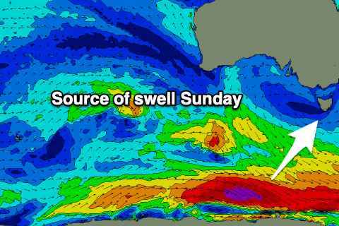
Sunday should provide a pulse of SW groundswell, generated by a very short-lived but intense fetch of W'ly gales on the polar shelf Thursday. A spike to 2ft+ is due, fading through Monday.
Conditions look clean in the morning again but a trough looks to bring a S'ly change into the afternoon.
Longer term, the outlook is positive, with a strengthening area of frontal activity south of the country later this weekend and into next week due to generate building levels of SW swell energy that might get sizey later next week. More on this Wednesday.