Increasing activity from later week

Southern Tasmanian Surf Forecast by Craig Brokensha (issued Monday March 18th)
Best Days: Tomorrow afternoon ahead of the change, Thursday morning, Saturday, Sunday, Monday and Tuesday mornings
Features of the Forecast (tl;dr)
- Small, inconsistent W/SW groundswell building tomorrow PM, easing Wed
- Strong N/NE winds tomorrow, tending W/SW into the evening, strong W/SW Wed
- Easing swell Thu with NW winds, tending W/SW through the PM
- NW tending strong SW winds Fri with a building W/SW swell later
- Moderate sized W/SW-SW swell for the weekend with W/NW tending W/SW winds
- Larger swell likely Mon with NW tending S/SE winds
Recap
Saturday offered a mix of easing S/SW energy and building S/SE groundswell that increased from 2-3ft in the morning more to 3ft+ into the afternoon but with sea breezes. The swell then eased slowly through yesterday with variable morning winds ahead of sea breezes again.
Today there's not much left in the tank, with tiny, fading surf.

S/SE swell into Saturday PM
This week and weekend (Mar 19 - 24)
Looking out our inconsistent W/SW groundswell due through tomorrow afternoon and this has been downgraded a touch thanks to the low not being as healthy. Slow 1-2ft waves are due into the afternoon, easing from a similar size Wednesday morning, with some new mid-period SW swell due into the afternoon as a cold front pushes up and across us.
This looks to reach 2ft+ before easing back from 2ft Thursday morning.
Winds look to hold offshore longer tomorrow but with strength, creating tricky conditions. A strong N/NE breeze is only due to shift W/SW into the evening so there should be a chance for a surf as the swell builds.
Wednesday will then be poor with strong W/SW winds in the wake of the change. Selected pockets might be OK for a paddle.
Thursday looks fun with NW winds holding all morning, only shifting W/SW into the afternoon as the swell eases.
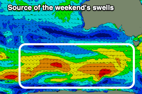
From Friday, we're set to see the swell building in size and energy across the region thanks to an active train of polar frontal systems moving in from the west. Initially there'll be relatively weak but persistent, generating swell to 2-3ft or so from later Friday but more so Saturday, holding Sunday.
A flurry of stronger activity looks to generate some larger swell into early next week, easing through Tuesday afternoon and Wednesday.
The models diverge slightly on the makeup of this stronger activity so check back here Wednesday for an update on the timing and sizes.
Local winds look favourable each morning, sea breezy into the afternoon's but we'll confirm this Wednesday.