Small windows of surf later week

Southern Tasmanian Surf Forecast by Craig Brokensha (issued Monday January 23rd)
Best Days: Beginners tomorrow morning, Thursday morning, Friday morning, Saturday morning, next week
Features of the Forecast (tl;dr)
- Tiny tomorrow with moderate N/NE tending strong E/NE winds
- Inconsistent W/SW groundswell building Wed with N tending E/NE winds ahead of a late S change
- Inconsistent mid-period W/SW swell Thu/Fri, easing Sat
- W/NW tending S'ly winds Thu PM, N tending strong NE winds Fri
- Inconsistent small SE groundswell Fri, easing Sat
- Strengthening N/NE-NE winds Sat
Recap
Our new SW groundswell due Saturday came in bang on forecast with strong 3ft sets that were a bit too straight for the beaches. The swell eased to a smaller 1-2ft+ yesterday under a light SE breeze and this morning it's smaller again with light winds ahead of a strong sea breeze.
This week and weekend (Jan 24 - 29)
A low point in swell is expected tomorrow morning with clean conditions ahead of weak sea breezes, while into Wednesday a new, inconsistent W/SW groundswell is due to build.
This was generated late last week by a distant polar low firing up around the Heard Island region and is expected to build to an inconsistent 1-2ft through the afternoon on Wednesday.
The swell is due to ease Thursday but we should see some fun, reinforcing mid-period W/SW energy from Thursday through Saturday morning, generated by weak fetches of W/SW winds to the south of Western Australia and just west of us mid-week.
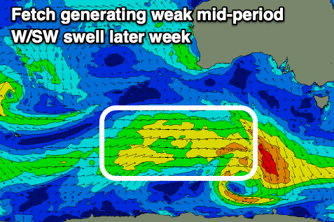
This should maintain 1-2ft surf Thursday and Friday with easing sets from 1-1.5ft on Saturday morning.
Looking at the local winds and Wednesday morning will be offshore ahead of E/NE sea breezes and a late S'ly change with a trough.
Thursday should see W/NW winds in the morning ahead of another trough and S'ly change into the early afternoon, clearing for Friday morning with a return to N winds that will strengthen from the NE into the afternoon.
Strong N/NE-NE winds will dominate Saturday as the swell fades before a change moves through on Sunday.
Now also in the mix on Friday, easing Saturday with be a small, inconsistent SE groundswell. This will be generated by a strong polar low firing up to the south of New Zealand this afternoon and should provide 1-2ft sets at Clifton, bigger down the South Arm.
Longer term some good, inconsistent W/SW groundswell is due next Tuesday/Wednesday but we'll have a closer look at this on Wednesday.