A few swell sources, cleanest from late week

Southern Tasmanian Surf Forecast by Craig Brokensha (issued Wednesday January 18th)
Best Days: Friday morning, Saturday morning, possibly Sunday morning, Monday morning
Features of the Forecast (tl;dr)
- Small S swell Thu with strong SW tending S winds
- Easing surf Fri with W/NW-NW tending S/SE winds
- Moderate sized SW groundswell Sat AM with N/NW winds ahead of late AM sea breezes
- Easing surf Sun with light-mod S/SE winds
Recap
Fun easing surf yesterday morning with clean conditions before the winds came up, tiny today and with a strengthening onshore wind as a trough moves through.
This week and next (Jan 19 - 27)
Today's change will be linked to a trough moving across us, and attached to its southern flank will be a fetch of strong S/SW winds. This will produce a weak S'ly swell for tomorrow, coming in around 2ft across Clifton but with poor, strong SW winds lingering across the South Arm.
Friday will become much cleaner with a W/NW-NW offshore but the swell will be on the way out and fading from 1-2ft.
The weekend is looking better for surf thanks to the arrival of a new SW groundswell under favourable winds.
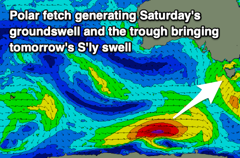
This groundswell is being generated by a strong polar low that's currently to the south of Western Australia and will produce a fetch of W/SW gales while projecting east today.
The swell should peak Saturday morning with good 3ft sets due across Clifton (2-3ft mostly), easing through the day.
A light N/NW offshore will create clean conditions Saturday morning before sea breezes kick in late morning, with Sunday looking a tough dicey as a trough sees unfavourable, lingering S/SE winds. We'll confirm this on Friday.
Beyond this swell there's nothing too major size wise due into next week until possibly Thursday/Friday. Check back on Friday for an update on the local winds for Sunday and next week's potential.