Lots of swell on the way, with an upgrade

Southern Tasmania Surf Forecast by Craig Brokensha (issued Monday 30th November)
Best Days: Every day this period (besides Sunday)
Recap
The surf bottomed out over the weekend with clean, tiny waves for beginners Saturday, tiny and onshore Sunday.
Today some new mid-period W/SW swell has filled in with clean, 2ft waves this morning.
This week and weekend (Dec 1 - 6)
Today's mid-period W/SW swell was generated by a cold front spawning off a strong, distant polar low that was south-west of Western Australia. This swell should hold tomorrow, but the less consistent W/SW groundswell from the low will also be in the water, offering 2ft+ sets across Clifton.
 Winds look great with a strong N/NE tending N/NW breeze and then W/NW late ahead of a strong and deepening low forming to our west.
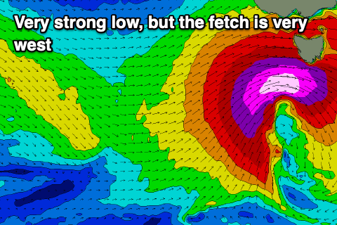
Now, this strengthening frontal system and low which was mentioned on Friday looks to be quite significant.
The low will form as a strong cold front pushing across Western Australia dips south-east, bringing a mix of warm, moist air into the colder, southern air mass, but it'll just fall short of being classified a 'bombing' system.
It will also form a little too far north initially for us, but we should see a great fetch of severe-gale W/SW winds generated through our western swell window tomorrow afternoon and evening, with the low sliding across us Wednesday morning.
What should result is a large W/SW groundswell for Wednesday, mixed in with localised mid-period energy, peaking through the day to 4-5ft across Clifton. Protected spots will be tiny owing to the westerly direction.
Winds will be strong as the low pushes across us with strong W/NW-W winds in the morning, shifting W/SW through the afternoon. A late swing back to W/NW is on the cards, but protected spots will be cleanest in short.
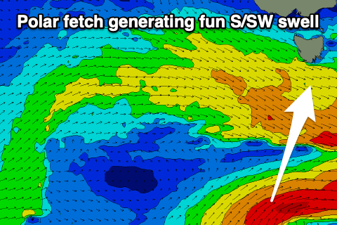 The swell will ease quickly into Thursday, dropping from 3-4ft, but a small fetch of SW gales firing up on the backside of the low, south of us Thursday should produce a reinforcing S/SW swell for Saturday afternoon. In between this the surf looks to drop to a small 1-2ft (Friday).
Winds on Thursday morning are great and should be N/NW, shifting NW into the afternoon, with N/NW tending W/SW winds on Friday.
Saturday's building S/SW swell will be fun and should build o 2-3ft through the afternoon and winds are a bit tricky but favourable with N/NW tending N/NE breezes.
This will be ahead of another strong low that's forecast to develop across us and drift south-east, bringing a localised increase in windswell Sunday. More on this in Wednesday and Friday's updates though.
Comments
Hallelujah!