Poor weekend, improving next week

Western Australian Forecast by Craig Brokensha (issued Friday May 20th)
Best Days: Perth/Mandurah Monday morning and Tuesday morning, all locations Wednesday morning, next Friday all locations
Features of the Forecast (tl;dr)
- Easing SW groundswell tomorrow with a large, mid-period S/SW swell building through the day
- Strong to gale-force SW tending S/SW winds tomorrow
- Easing surf Sun with strong S/SW winds
- Large mid-period S/SW and SW swells for Mon with E/SE-SE winds in Perth/Mandurah, gusty S/SW in the South West
- Reinforcing mid-period W/SW-SW swell filling in Tue, with a less consistent groundswell for Wed AM, easing
- Fresh S/SW winds Tue in the South West, E/NE to the north in the AM
- E/NE tending stronger N/NE winds Wed
- Oversized, long-period W/SW grounswell likely next Fri with E/NE-NE winds
Recap
Yesterday’s strong W’ly swell came in nicely across the metro regions with variable winds and improving conditions across Perth, semi-pumping before winds shifted onshore. Mandurah was decent as well but more lumpy with early light winds across northern regions in the South West, onshore to the south.
Today a larger W/SW-SW groundswell has filled in but conditions are poor in the South West and Mandurah, with a window of lighter N/NE winds across Perth and lumpy 3ft surf.

Great surf yesterday morning in Perth
This weekend and next week (Jun 21 - 27)
There’s no real change to the outlook for the weekend, with today’s large SW groundswell expected to ease, but a secondary polar front/trough pushing up and into us through this evening will bring with it some new, localised, large stormy surf from the S/SW tomorrow afternoon.
This will build through the day under strong to gale-force (in the South West) SW tending S/SW winds with no quality to be found at all. The South West looks to reach 10-12ft, 4-5ft across Mandurah and 3-4ft in Perth.
Unfortunately strong S/SW-SW winds look to linger into Sunday as the trough forms a low south of the state, becoming slow moving eastward.
Another polar front pushing up and across the South West of the state during Sunday will bring with it another episode of large, mid-period S/SW swell for Monday, mixed in with some mid-period SW swell generated by a fetch of polar fetch of NW gales currently east of the Heard Island region.
This should see the South West coming in at 8ft to occasionally 10ft, 3ft+ Mandurah and 2-3ft Perth.
A slow moving high pressure system will start to edge in through next week and this should bring better E/SE winds across the metro regions Monday morning, still fresh from the S/SW in the South West.
Tuesday unfortunately still looks onshore across the South West with a slight drop in size from Monday, with Perth/Mandurah expected to see early, light E/NE offshore breezes.
During the day Tuesday, some new W/SW groundswell is due, generated by a slim fetch of W/NW gales feeding into the backside of the frontal activity clipping us on the weekend and early next week.
This should provide 8ft+ sets across Margs, 3ft Mandurah and 2ft+ Perth, while a secondary reinforcing groundswell to a similar size is due Wednesday morning from the earlier stages of this frontal progression.
Winds look to finally swing offshore Wednesday morning across the South West and E/NE, strengthening quickly from the N/NE as the next system starts to move in.

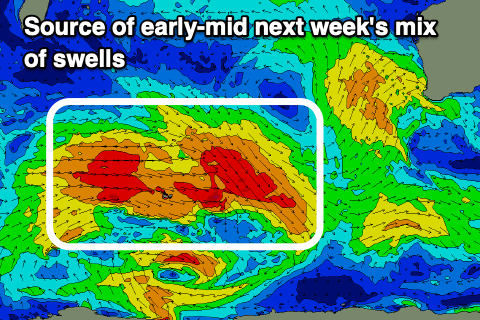
The next system will be a weakening trough, attached to a significant mid-latitude low that will form south-east of Madagascar Sunday.
This northward positioned low is forecast to project a fetch of S/SW-SW gales obliquely to our western swell window while moving east before dipping more favourably south-east and strengthening through early next week.
What will result is a large, powerful long-period W/SW groundswell next Friday, likely coming in at 12ft+ across the South West, 3-5ft Mandurah and 3ft+ Perth under E/NE-NE winds. This is still a while out so check back here Monday for the latest. Have a great weekend!
Comments
The winds strangely held off on Saturday morning in Perth, but the swell was there, allowing me to snag a novelty wave in the rain.
Yeah, didn't expect that and I don't think Access C picked it either. Looked chunky.
saw that - looked sic! heard it flattened out pretty quickly off the wall?