Generally average week, much better from Friday into the weekend

Victorian Forecast by Craig Brokensha (issued Monday June 23rd)
Best Days: Wednesday morning Surf Coast (low expectations), Friday morning Surf Coast, Saturday, Sunday, Monday exposed beaches
Features of the Forecast (tl;dr)
- Small tomorrow with strengthening N/NW winds
- Moderate sized W'ly groundswell for Wed AM, with some slightly bigger mid-period energy in the mix and PM windswell increase
- Strong W/NW tending SW winds Wed
- Easing mix of swells Thu with strong but abating S/SW winds
- Moderate sized S/SW groundswell for later Thu but more so Fri AM, easing
- Light W/NW tending S/SW winds Fri
- Moderate + sized SW groundswell filling in Sat, peaking in the PM, easing Sun
- Inconsistent, long-range W/SW groundswell for Sun
- Local offshore tending variable winds Sat, N/NW-N tending NE Sun
Recap
Saturday was small and slow with an inconsistent W/SW groundswell holding 2ft+ across the Surf Coast magnets with 4ft waves to the east under generally northerly winds.
Our inconsistent W/SW-SW groundswell started to show later in the day Saturday but peaked through Sunday morning with inconsistent but great 3ft waves on the Surf Coast, chunky and 4-6ft to the east.
The swell eased through the day with today coming in much smaller under stronger northerly winds.

Great conditions when the sets came early yesterday
This week and weekend (Jun 24 - 29)
With the weekend’s swell on the way out we look towards the strong cold outbreak pushing through over the coming days, with the swell potential now looking mostly suspect.
This is again thanks to the mid-latitude storm activity moving in from under Western Australia for the most part sitting too far north of our swell window.
The whole progression looks to generally sit too far high, up in the Bight, with the southern edge of an incoming frontal system just sitting without our western swell window.
With this in mind lower your expectations in regards to size and consistency with this coming swell.
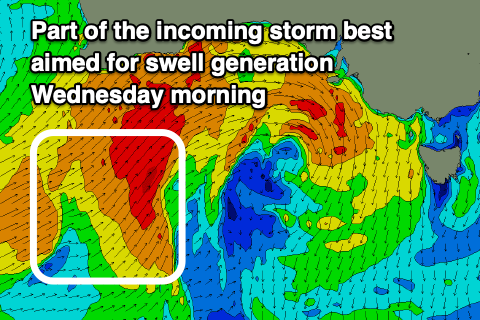
Looking at the arrival times, and the best pulse of W’ly groundswell is due Wednesday morning, generated by the fetch of SW gales that are currently sitting south of Western Australia, projecting east-northeast through today.
This itself looks to generate 3ft+ of W/SW groundswell for the Surf Coast with 5-6ft waves to the east, but on top of this, some localised W/SW energy from the remnants of the progression moving through Tuesday night is due, pushing wave heights more towards 4ft on the Surf Coast and 6ft+ to the east.
Like last Wednesday, the mix of swells are likely to come in lumpy and jumbled, with strong, morning W/NW winds due to shift strong SW into the afternoon. This will also kick up some junky windswell later, easing through Thursday but with strong, abating S/SW winds.
All in all the event looks to be average besides a window of slow waves Wednesday morning.

The surf will continue to ease into Friday, but a new S/SW groundswell is due overnight Thursday, easing under a light W/NW offshore ahead of sea breezes.
The source will be a polar fetch of S/SW gales sitting south-southwest of Tasmania through tomorrow, with the Surf Coast due to ease back from 3ft+ with 4-5ft sets to the east.
Looking at the weekend outlook, and our good groundswell flagged through last week is on track.
A strong mid-latitude low that’s currently south-east of Madagascar is generating gale to severe-gale S/SW winds, aimed out of our swell window, but it’s due to track east-southeast over the coming days while strengthening. This will see a fetch of severe-gale W/SW winds aimed through our western swell window while dipping south-east of Western Australia, generating some long-range, inconsistent W/SW groundswell for Sunday, but it’s the developments once it continues tracking south of the country that are of more interest.

The system is due to strengthen south of WA, a polar latitudes this Wednesday/Thursday, with a great fetch of severe-gale to possibly storm-force W’ly winds being projected through our south-western swell window.
This will generate a moderate + sized SW groundswell for Saturday, peaking through the middle of the day/afternoon to 3-5ft on the Surf Coast and 6ft+ to the east. The GFS weather model has the system a little stronger and an earlier peak than ECMWF, and right now I’m tending towards ECMWF as always.
Winds look locally offshore tending variable on Saturday with N/NW-N tending N/NE winds on Sunday as the swell eases. Longer term the outlook is slow so make the most of Friday onwards!
Comments
lord craigos thank you for the gorgeous weather, light offshore winds and fun beachies over the weekend. Much appreciated! I put a few extra sampos and beers under your shrine this morning. Looks like another cooking forecast ahead, bless you!
glad the wind was light yesterday morning, cos good CHRIST it was cold enough already.
Craigos - big thanks for how early you're getting these reports out. Really gives my productivity a boost to read them and then get stuck into my day. Legend.
That’s a fair downgrade for Wednesday. Oh well.