Strong, though west swell incoming

Southern Tasmania Surf Forecast by Craig Brokensha (issued Wednesday 18th November)
Best Days: Tomorrow selected spots, dawn Friday for the keen, Saturday morning, Sunday and Monday beginners
Recap
A continuation of tiny surf yesterday and today.
This week and weekend (Nov 19 - 22)
After the run of tiny surf we've got our good pulse of inconsistent W/SW groundswell due to build through tomorrow, peak later and then ease slowly Friday.
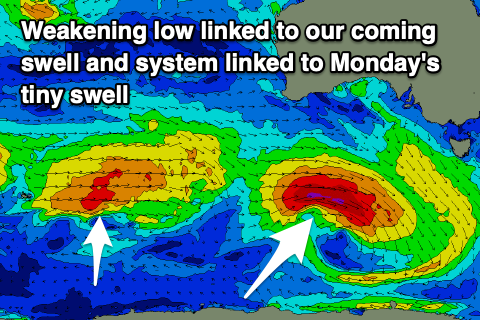 This will be linked to a 'bombing low' forming south-west of WA on Monday, dropping east-southeast through our swell window. A fetch of severe-gale to storm-force W-W/NW winds were generated just within our swell window and since the low has slowly weakened while projecting east, more favourably into our swell window.
This will generate a prolonged W/SW groundswell event, with a tiny start tomorrow morning, though kicking strongly after lunch and reaching a strong, straight 3ft into the late afternoon across Clifton.
The swell should drop back to 2-3ft Friday morning, easing later in the day and dropping further from 1-2ft on Saturday morning.
Winds tomorrow morning look variable out of the N'th, tending E/NE through the day and strengthening into the evening as the swell really kicks, favouring some spots over others.
Friday still looks dicey with a dawn variable breeze out of the S'th due to quickly increase, fresh through the day and strong into the afternoon as a surface trough pushes in from the west.
Saturday should be cleaner with a N/NE offshore, strong into the afternoon out of the E/NE as the swell eases.
Beginners should head out Sunday when the surf will be tiny with a morning N'ly, E-E/NE into the afternoon again.
Longer term there's nothing too significant on the cards for the coming week with a tiny, mid-period W/SW swell Monday unlikely to get above 1ft, while a change Tuesday may kick up a weak windswell.
More on this Friday though.