Poor outlook until later next week

Southern Tasmania Surf Forecast by Craig Brokensha (issued Monday 26th October)
Best Days: Next Wednesday
Recap
Bumpy 2ft waves on Saturday for the keen, with more size yesterday but with persistent onshore winds.
Today conditions have remained onshore with 2-3ft of swell.
This week and weekend (Oct 27 – Nov 1)
The swell seen yesterday and today will start to ease through this afternoon, backing off further from 1-2ft tomorrow morning with pesky and average E/SE winds, similar Wednesday but more from the E-E/NE.
These unfavourable winds are linked to a surface trough deepening off the southern NSW coast, squeezing a strong high to our west-southwest and directing E/SE winds into the state.
There's no real swell expected off these winds for the South Arm either, but the North-East Coast will see better surfing options.
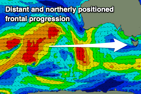 Moving into the end of the week, a very west and inconsistent groundswell is due, generated between the Heard Island region and Western Australia over the weekend and into today.
The position of the swell generating progression was too far north for us, and also in our far swell window so we'll be lucky to see any size over 1ft as it peaks Friday, easing slowly through the weekend.
Winds look onshore out of the S/SW in any case as another surface trough moves in from the west.
Winds should ease and become more variable Saturday morning but with no surf.
Longer term there's nothing significant on the cards until later next week when we should see a strengthening though not too significant node of the Long Wave Trough moving in from the west.
This should bring an increase in Southern Ocean frontal activity, but more on this in Wednesday's update.
Comments
Welcome back to the chair Craig
Thanks Horace.