Easterly long-player on the cards for next week

South-east Queensland and Northern NSW Surf Forecast by Ben Matson (issued Wed 15th March)
Forecast Summary (tl;dr)
- Easing SE' swell Thurs, all but gone by Fri
- Small E'ly swell for the weekend (not much size south from Yamba)
- Small, flukey S'ly swell at times over the weekend (not much size north from Byron)
- Extended run of decent trade swell building from Monday onwards, holding into the weekend
- Chance for a few embedded pulses of large surf (early days though)
Recap
The expected E'ly swell performed inline with expectations across the Mid North Coast through Tuesday afternoon and Wednesday, reaching 3-5ft and with moderate SW thru' S'ly winds on Tuesday tending light offshore today with a weak afternoon sea breeze. However, surf size performed better than expected across the Northern Rivers though (note: direction being more SE here), reaching a solid 4ft at most spots, and even the exposed ends of the Gold Coast pushed 3-4ft at times (smaller on the Sunny Coast), with size holding into this morning ahead of a steady easing trend throughout the day. Southern points were a foot or two smaller though, and early light winds cropped up from the north throughout the day.
This week (Mar 16 - 17)
No major change to the forecast issued Monday.
We reached the peak of the current swell cycle early this morning, so it's a continual downwards trend from here, and Northern NSW (particularly the MNC) will see the most size as wave heights continue to fade.
Fortunately, conditions should be clean in most areas with light winds and sea breezes.
Don't expect much more than 1-2ft across exposed SE Qld beaches early Thurs (smaller at the points and sheltered southern ends), with 2ft surf across the Northern Rivers and maybe some rare 2-3ft sets across the Mid North Coast first thing, before it continues to ease.
Friday will be even smaller, so make the most of Thursday.
This weekend (Mar 18 - 19)
Generally light winds and sea breezes are expected this weekend, so surf conditions should be clean through the mornings.
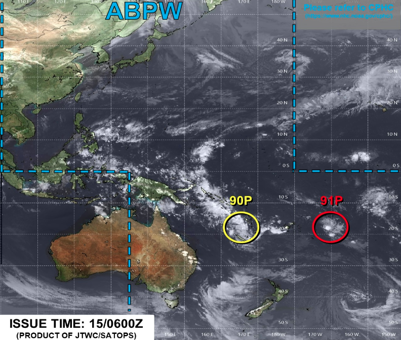
Although no major size is expected, we should see a minor increase in slow east swell, sourced from the early stages of a developing ridge north of New Zealand that is playing a supporting role to a pair of tropical disturbances straddling the Fijian region (see below).
At this stage we're probably looking at an increase into the 2ft+ range throughout SE Qld and Far Northern NSW on Saturday (not likely early), holding into Sunday, though I'm expecting slightly smaller surf south from about Yamba, owing to the less favourable fetch alignment.
A couple of small southerly signals may also show up at south facing beaches over the weekend, sourced from a brief front exiting eastern Bass Strait on Friday, and another broader, though poorly aligned system south of Tasmania over the coming days. However, only south swell magnets south of Byron will pick up any size, with stray 2ft+ sets at best. There'll be long waits for the bigger waves.
So, sniff around if you're keen but it may require some legwork, especially south from Byron.
Next week (Mar 20 onwards)
Our eastern swell window remains the focus for the coming week.
The aforementioned pair of tropical disturbances are part of an evolving atmospheric dynamic that will concurrently occupy the Coral Sea, Northern Tasman and South Pacific basins over the coming days.
Right now, a ridge is building to the south of this region, and this will offer some support to the tropical features (irrespective of whether they reach cyclone status). And from a swell generating point of view, this is important as the disturbances themselves are currently too small in size (and fetch length) to generate any meaningful swell. Though, of course this may change.
So, thanks to the ridge - which will quickly fill into the Coral Sea over the weekend - as a minimum we can expect at least a week of useful trade swell, building late Monday to 3-4ft, possibly nudging a little high on Tuesday and Wednesday, and then maintaining a decent size range for the semi-exposed points and beachbreaks into the weekend and maybe early the following week.
The disturbances are the wild card in the mix. They'll have the potential to strengthen, and thus super-charge this fetch (thereby generating much larger surf) which has certainly been suggested several times over the last eight model runs (since Monday's notes were prepared) however there's too much divergence at this stage to have confidence in a major swell event.
So, let's see how things look on Friday.
Otherwise, there's a suggestion for a strong southerly change across the Southern NSW coast (maybe associated with a Tasman Low) early-mid next week, so we'll have south swell on the make too. But, winds do look tricky through this period.
All in all, it's a little too far out to be confident in specifics but next week is certainly looking quite dynamic. Which usually means a few windows of opportunity for keen surfers.
Comments
Cheers Ben. Magic morning today. Bring the cold.
Forecast spot on for MNC kept building all Tuesday and pulsed into the arvo still pulsing early Wed morning but was losing its consistancy by lunch
Agreed, great forcasting Ben. Most appreciated.
Thanks chaps. Nice to be back for a brief stint on the bench, even if my skillz are a little rusty.
Magic conditions this morning, with some fun little peaks to boot.
Ben did you realise that clicking on the "Surf Forecast" at the top of this page takes you through to the Supertubos forecast?
Before that it went through to the Pipe forecast.
I think it goes to wherever you last looked if you know what I mean. Mine goes to Middleton cos I came directly here from the home page, but the last report I looked at was Middleton
Yeah it's a weird coding thing that we've never been able to fix. Easier to start off at your forecast homepage. Will be fixed with an upcoming site tweak.
It seemed to be ok until about a few months ago.
Looks like local winds are gonna be crap for this swell.