Average waves this week, next week's looking much better

South-east Queensland and Northern NSW Surf Forecast by Ben Matson (issued Mon 13th March)
Forecast Summary (tl;dr)
- Punchy E'ly swell building Tues, easing Wed, though biggest on the MNC, smaller Northern Rivers, very small SE Qld
- Small surf Thurs, Fri, Sat
- Fun E'ly swell building Sun PM across SE Qld and Northern NSW
- Chance for a strong E'ly swell early-mid next week
Recap
Another pulse of long period E'ly swell on Saturday produced inconsistent 3ft+ sets across many regions, before easing to 2-3ft on Sunday, with smaller surf reported south from Yamba. Conditions were generally OK with variable winds from around the compass. Smaller surf today has been accompanied by freshening southerly winds. We have seen building short period SE swells across the Mid North Coast this afternoon, with size now pushing 3ft at south facing beaches.
This week (Mar 14 - 17)
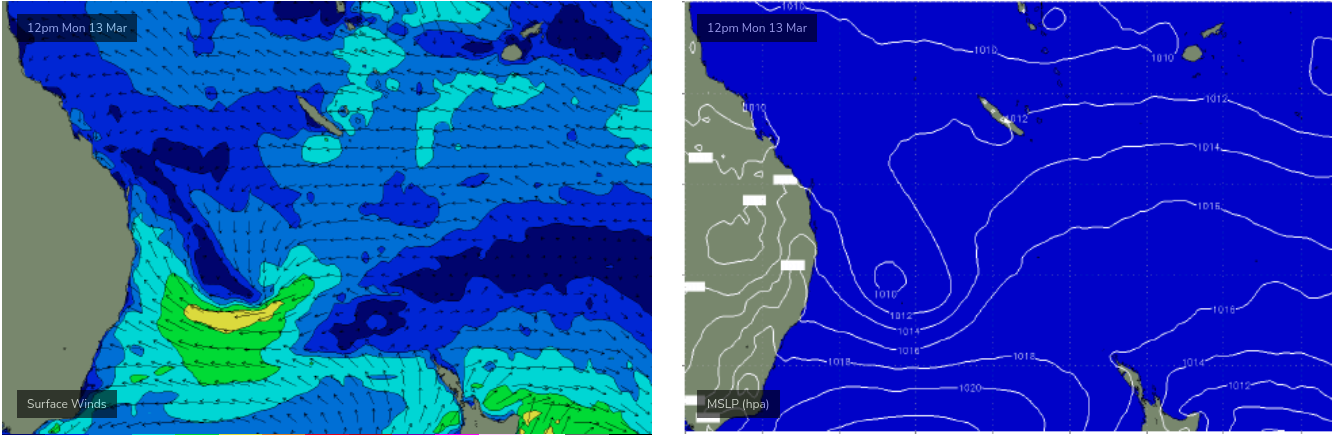
A low pressure system sitting near Lord Howe Island has a reasonable belt of easterly winds on its southern flank, generating new E/SE swells across the Mid North Coast.
The low is expected to re-align its orientation on Tuesday, and by Wednesday will start to transition outside of our swell window, so maximum surf size from this episode will peak Tuesday afternoon and then ease steadily through Wednesday.
And unfortunately, the orientation of this low (see below) means that surf size will be smaller across the Northern Rivers (compared to the MNC), with SE Qld picking up very little size.
Tuesday's increase should reach 3-5ft across the Lower MNC, with 3-4ft north through to about Yamba and then 2-3ft surf to the border. Easing SE winds will tend S'ly through the day so keep your expectations low, there'll be some small runners on the sandy outer points but it won't be epic.
SE Qld will see the most size at exposed northern ends on Tuesday afternoon, with sets to 2-3ft, however we'll see much smaller surf across most beaches and the semi-exposed points, only 1-2ft. So expect to do quite a bit of grovelling.
Wednesday should be fun across the open beaches south of the border (biggest across the MNC) with light offshore winds and sea breezes, and easing E'ly swells. By Thursday and Friday it'll be pretty small across these regions though. Expect northerly winds at times too.
SE Qld is looking at a slow, lacklustre finish to the working week with small surf at the swell magnets.
This weekend (Mar 18 - 19)
Saturday looks to deliver small swells from peripheral sources.
The most dominant is likely to be a couple of fleeting pulses of southerly energy from a poorly aligned frontal progression south of Tasmania later this week. Most beaches will dip out completely, but some south facing beaches may pick up stray 2ft sets both Saturday and Sunday.
Sunday has some promise for an easterly swell to fill in, sourced from two regions: a minor strengthening of the trades north of New Zealand later this week, and the southern flank of a tropical cyclone that's expected to form off the southern region of Vanuatu mid-week, and the move to a position near New Caledonia by Friday.
Its still early days, and the cyclone's proximity to New Cal significantly lowers confidence levels - but with locally light winds there could be some fun 3ft+ sets by mid-late afternoon Sunday, across SE Qld and Far Northern NSW (smaller across the MNC owing to the longer travel time). I'll refine in more detail on Wednesday.
Next week (Mar 20 onwards)
There's a lot to like about the synoptic signal in the Coral Sea and South Pacific over the long term.
Dual cyclones are a possibility, but more promising is a broad supporting ridge to the south which as a mimimum should ensure a long lived easterly event that'll build through Monday, peak Tuesday and then maintain plenty of waves through the second half of the week.
However, there's been a LOT of variation in the last few runs, so we really need quite a few more days to firm things up. I'll have more on the specifics on Wednesday.
Comments
Let's hope next week is not accompanied by never ending onshores!
well Wednesday morning was a surprise - a good surprise - definitely bigger than expected at a GC magnet... happy days