Yeah, nah

South-east Queensland and Northern NSW Surf Forecast by Ben Matson (issued Friday 22nd November)
Best Days: No great days.
Recap: Small swells and northerly winds. Yeah, nah.
This weekend (Nov 18 - 19)
Northerly winds will remain the dominant feature for the next four days.
Saturday will be stronger than Sunday, and wind strengths will be greatest along the Lower Northern Rivers and Upper Mid North Coast, and lightest in SE Qld - but without any notable swell it’s gonna be hard to find anything worthwhile.
The only exception worth pointing out here is the Lower Mid North Coast, which may feel the effects of a trough to the south and could see variable winds at times.
We’ve got only a couple of average swell sources on the cards anyway. Northern NSW will pick up small windswells generated by the local fetch (no thanks!), and Sunday may see a brief flush of small S’ly swell across the Lower Mid North Coast from a temporary strengthening of the trough off Southern NSW overnight. No major size is likely though.
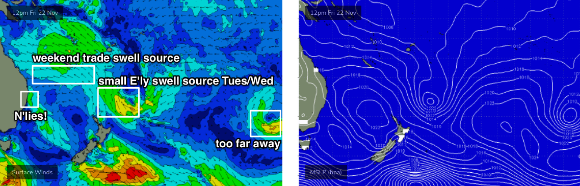
SE Qld will pick up the other energy, being some trade swell generates from a ridge just south of New Caledonia. The Sunshine Coast should see slow, lumpy 2-3ft sets and we’ll see slightly smaller surf size as you track south from the Gold Coast.
All in all, not very inspirational. Good luck!
Next week (Nov 20 onwards)
The storm track is all out of whack for our swell window right now.
Southern Ocean fronts are poorly aligned, there’s not a lot of activity happening in our tropical swell window (though we may see an early season TC north-east of Vanuatu next week), and generally troughiness along the coast will generate small local swells but nothing of any great substance.
There's actually a nice sub-tropical low developing NE of New Zealand right now, but most of the fetch is aimed up into the Fijian/Vanuatu region. We may see a small spread of E’ly swell around Tues/Wed but I’ll be surprised if there’s much more than a lazy 2ft at exposed beaches.
As for conditions, Monday and Tuesday will continue the northerly regime but this somewhat extended pattern will be disrupted by a strong front tracking into the lower Tasman Sea late Tuesday, that’ll push a fresh S’ly change into Northern NSW on Wednesday. We’ll see light winds persisting into early Thursday before the northerly machine cranks up again from Thursday afternoon through Friday and Saturday.
Late Wednesday could see some 3ft+ sets across Northern NSW (associated with the southerly change) but with average conditions isn’t not worth worrying about too much at this stage.
As mentioned above, we may also see a TC near Vanuatu next week - early indications suggest it’ll remain inside the swell shadow, but it’s early days. I’ll keep an eye on it over the weekend and will update if the models swing in our favour.
Have a great weekend! See you Monday.
Comments
Regarding the TC, the way things are going, the models definitely wont swing in our favour
I was just west of Fiji on the 27th. No swell from the TC to the north. The "too far away" swell did hit Tonga, junky though.