Extended period of great waves across the Queensland points

South-east Queensland and Northern NSW Surf Forecast by Ben Matson (issued Monday 3rd March)
Best Days: Great waves across the outer SE Qld and Far Northern NSW points all week, and into the weekend. Good beachies across Northern NSW on Saturday and Sunday as winds and wave heights ease.
Recap: Fresh S’ly winds all weekend and today have confined the best waves to sheltered locations. Saturday played out below size expectations (as suggested was a possibility in Friday's notes) but wave heights built late afternoon and further into Sunday, with the surf levelling out today around 6-8ft at south swell magnets south of Byron, and 4ft across the outer SE Qld points. And it’s still very brown.
This week (Apr 4 - 7)
Note: Forecaster Notes will be brief this week because Craig’s on leave.
No changes to the Forecaster Notes from last Friday, really.
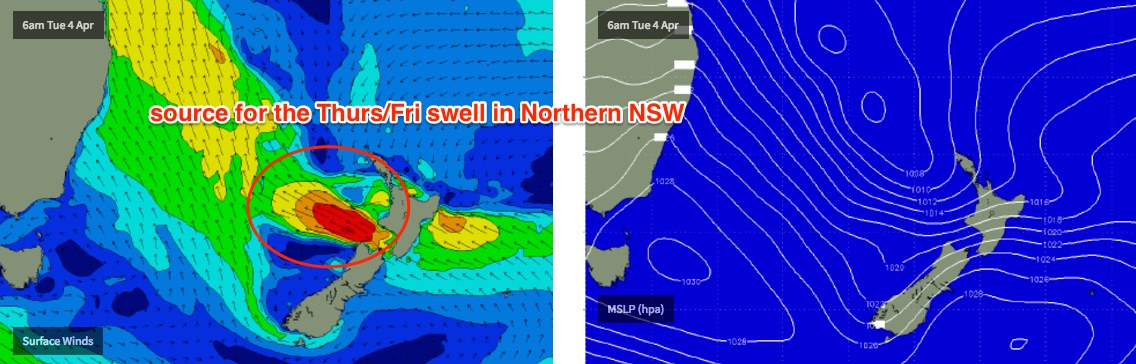
A strong ridge extends across the Central/Northern Tasman Sea, aimed up into the Coral Sea. This fetch is stationary, aimed nicely into the Coral Sea and will continue to pump out similar sized surf over the coming days. It’ll also maintain the southerly regime on Tuesday before winds veer more SE into Wednesday and Thursday and then slowly weaken as the ridge relaxes and retreats north-east.
So, the outer SE Qld points should hover either side of 4ft for the next few days before easing slowly from Thursday onwards. Expect smaller surf at sheltered locations.
South of the border, you’ll have to look for protection from the wind, but for reference we should still be looking at 6-8ft surf at south swell magnets south of Byron on Tuesday (smaller for Coffs south, due to the slightly less favourable fetch alignment), with the best options across the various points and sheltered locations where it'll be much smaller. Size will then start to ease slowly through Wednesday though should still be very solid early morning.
On Tuesday, E/SE gales are expected to develop through western Cook Strait (the body of water separating the North and South Island of New Zealand) and this will set up a longer period E/SE swell for Thursday, but mainly across Northern NSW. This is good timing because surf size will start to ease a little more steadily by Thursday, so the new swell will reinforce wave heights back into the 4-5ft+ range across open beaches south of Byron Bay into the afternoon. Expect a slight easing trend through Friday afternoon.
This swell direction isn’t great for SE Qld but we should see a small boost here late Thursday and into Friday morning with inconsistent sets of around 3ft at outer points and open beaches, with smaller waves along the sheltered points.
Local winds will be much lighter through Thursday and Friday though still generally onshore. However the weaker pressure gradient should allow for a period of lighter, more variable winds in the early morning, south of the southern Gold Coast - but the northern Gold Coast and Sunshine Coast are likely to be under the influence of a reinforcing ridge through the Coral Sea and therefore should see continuing SE winds during this period.
However, the upside is that these local SE winds will continue to generate useful trade swell through the end of the week and into the weekend for SE Qld. So, this is a bonus - mainly because it’ll provide a more consistent supply of small waves for sheltered locations, compared to the less consistent E/SE groundswell. In fact the Sunshine Coast could see larger sets at exposed beaches than locations to the south on Friday (i.e. 3-4ft+), with smaller waves running down the protected points.
This weekend (Apr 8 - 9)
We've got plenty of trade swell for SE Qld all weekend.
The Sunshine Coast should manage bumpy 3-4ft+ sets at open beaches on Saturday, with 3ft surf on the Gold and Tweed Coasts and then smaller surf south of Byron Bay. This should persist into Sunday.
Northern NSW will otherwise see slowly easing size from the E/SE groundswell; initially some 3ft+ sets at exposed beaches Saturday morning but becoming smaller throughout the day. Much smaller surf is expected from this source on Sunday though all regions will continue to see small levels of trade swell (biggest in the north).
As for winds, SE Qld will remain under the influence of the ridge on Saturday so moderate to fresh SE winds at times, but south of the border we’ll see light variable winds on Saturday. The ridge will relax into Sunday creating light variable winds just about everywhere.
Next week (Apr 10 onwards)
A strong S’ly change will push up the Southern NSW coast on Sunday afternoon. Early next week has a suggested Tasman Low meandering through the southern Tasman region from Monday thru’ Wednesday, which has the potential for a couple of days of solid south through south-east swell across Northern NSW. It’s still early days though.
It also looks like we’ll see a Tropical Cyclone develop to the SE of Fiji later this week and remain slow moving in the South Pacific for some time, under a weak steering pattern. Whilst this cyclone is expected to become quite intense, the initial lack of a supporting ridge to the south plus the large distance between it and the mainland will reduce its swell potential for the East Coast of Australia. That being said, tropical cyclones are erratic at just a few days forecast time (let alone a week) so we’ll have to keep a close eye on this for swell potential next week.
But at this stage, early indications suggest small long period E'ly swell mid-late next week.

Comments
Forgot to upload these stills from Snapper last night.. how's the buttery walls!
Still solid today though less consistent it seems.
Nice runners at Currumbin too.
Have a close look at Currumbin.
For some strange reason, this bottom turn reminds me of Flinno at Easter Reef mid-80's, except 15ft smaller.
Yesterday had half the people and was twice as good at Noosa, the irony being everyone must of txted each other "it's going to be on" then find out its 1-2 foot and a shitty gold coast vibe permeates the water. Normally I just Laugh but its hard not to feel pathetic. Shame on me for joining the circus.
is that the circus of chatter ..to much chatter !!! ,,,
any one here been or spent time in the snow . ?
ugh, please will this SE wind just bugger off
Coffs! It's pumping this morning. Where is everyone?
shit i'm going to coffs ... hey where did that little video piece of greemmount last firday go to ...????
Nah, Coffs is terrible, don't bother