Dynamic period ahead for Southern Queensland

South-east Queensland and Northern NSW Surf Forecast by Ben Matson (issued Wednesday 29th March)
Best Days: Fri: chance for a brief window in SE Qld early morning with an easing NE swell and an early offshore wind. Points only once strong S'lies push through. Sat: easing S'ly swell and S'ly winds, best suited to SE Qld outer points. Mon thru' Thurs: building trade swell, best suited to SE Qld points.
Recap: TC Debbie provided only small residual NE swells through Thursday, occasionally reaching 2ft at a handful of exposed beaches but otherwise not generating any meaningful surf across SE Qld. Northern NSW was tiny. Today we’ve seen a continuation of tiny conditions across the coast with freshening N’ly winds.
This week (Mar 30th - 31st)
Note: Forecaster Notes will be brief this week because Craig’s on leave.
We’ve got a very dynamic period of weather ahead.
In addition to a lot of wind and surf, we’re also going to see very large rain totals across parts of Northern NSW and SE Qld over the next few days. This will affect water quality so be mindful when surfing near any stormwater outlet, creek or river.
The remains of TC Debbie are tracking southwards, and will merge with a northwards advancing southerly change that’s due to push across Northern NSW overnight Thursday and into Friday morning.
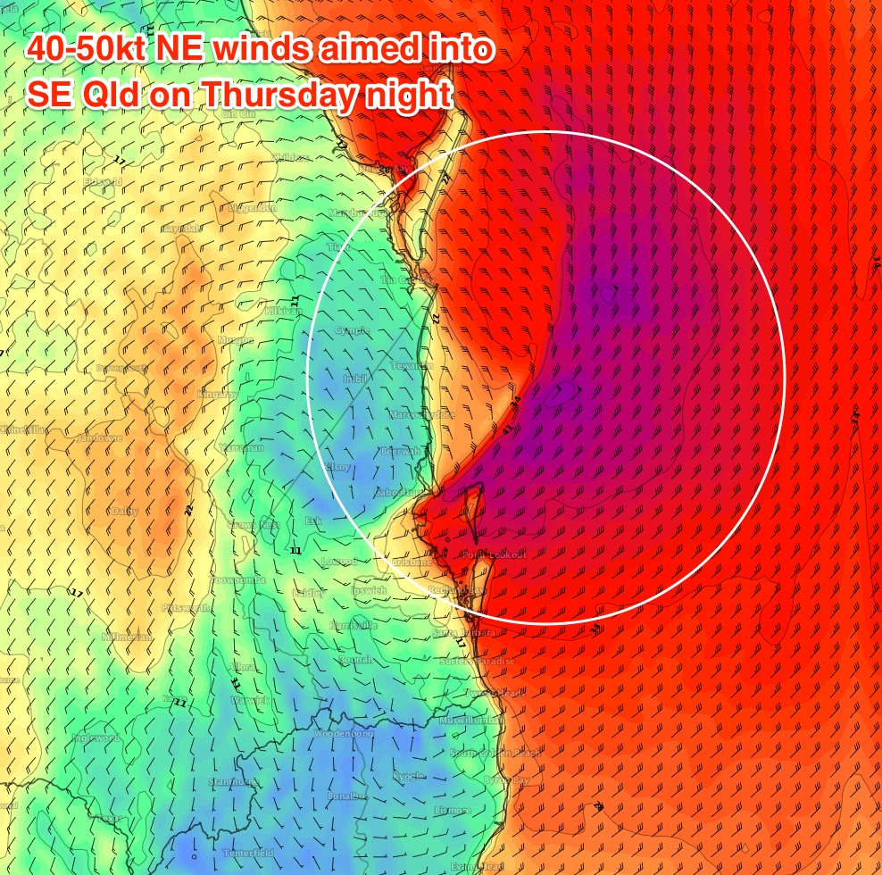
Whilst Thursday will probably start out with small, northerly affected conditions across most regions, these winds will strengthen during the day and by close of business we could see some impressive surf heights across NE facing beaches, mainly around SE Qld and the Far North of Northern NSW.
Maximum wind strength is expected immediately off the SE Qld coast overnight Thursday with 40-50kts (!) aimed point blank into the Gold Coast around midnight. At this stage I'm expecting stormy 4-5ft sets at NE facing beaches late afternoon and early evening, though it’s unlikely that there’ll be any locations offering shelter from the gale force NE flow. Surf size will be smaller surf out of Byron but of similar dubious quality.
A low pressure system will then develop east of Coolangatta in the early hours of Friday morning. Storm force S’ly winds will cross the border around dawn, however we should see an early period of fresh W/SW winds across the Sunshine Coast and possibly - if we’re lucky - the Gold Coast - if only for an hour or so. Everywhere south of about the Tweed Coast is likely to be under the influence of gusty S’ly winds by the time the sun rises though.
This presents a possible window of opportunity for Qld surfers. The NE swell expected to build later Thursday will peak overnight, but due to the close proximity of the swell source to the mainland, and the fetch’s rapid transition out of our swell window, surf height will steadily drop from about midnight onwards.
So, how much NE swell will be left at dawn? I’m willing to bank on 3-4ft sets across the Sunshine Coast at first light and 3-5ft across the Gold and Tweed Coasts (overnight could see easy 6-8ft sets - I can’t wait to assess the buoy data!) but it’ll be trending downwards by the minute so could be half the size by mid-morning. And by then we’ll be under the influence of gale force southerly winds.
So, there’s a chance for a brief beach break session at dawn in SE Qld. After that, we’ll only be able to surf the points under the southerly flow however the sheer strength of the wind will override the directional and proximity deficiencies, and should kick up surf size to 3-4ft+ along the outer SE Qld points by Friday afternoon. Expect much smaller surf at protected points.
Friday will be much bigger south of the border, being a combination of small to moderate (and easing) N/NE swell plus a large short range S’ly swell. However it’s hard to imagine many places will cope with the likely strength of the southerly breeze.
This weekend (Apr 1 - 2)
The Tasman Low is expected to slowly weaken over the weekend and retreat E/SE into the Central/Southern Tasman Sea.
This will cause surf size to slowly abate from the south, though Northern NSW will retain large wave heights for the first half of the weekend - 6ft+ early Saturday morning (south facing beaches), down to 3-4ft on Sunday. Winds will remain out of the southern quadrant; there’s a chance for an early SW breeze in the mornings, but in general you’re going to have to seek protection from the wind. Protected locations will be smaller.
This southerly flow will favour the SE Qld outer points but as the fetch weakens, so too will the swell period and this will cause wave heights to ease in size - exacerbated by the straight S'ly swell direction. Early Saturday morning should see inconsistent 3ft sets at the outer points, easing to 2-3ft by the afternoon and further to 1-2ft throughout Sunday. South facing beaches will see larger surf (easing from 3-5ft to 2-3ft+ over the course of the weekend) - however these locations will be wind affected.
Next week (Apr 3 onwards)
We’ve got a stack of surf on the cards for next week.
First up - Sunday’s S’ly swell for the Tasman Low will continue to ease into Monday.
However, exposed south facing beaches in Northern NSW will pick up a very long period (18-20 second) S’ly groundswell originating from a sneaky polar off the Ice Shelf south of SA today and tomorrow (generating very large surf for Victoria late Saturday and into Sunday). South swell magnets south of Byron Bay may see occasional 3-4ft sets from this source though there will be extremely long breaks between waves.
There’ll also be some short range S’ly swell across Northern NSW from a weak front entering the southern Tasman Sea on Sunday.
But the most prominent source will be a strengthening ridge through the Northern Tasman Sea and Coral Sea from Sunday onwards. This will drive strong SE winds through our immediate swell window and will kick up a solid trade swell across SE Qld and Far Northern NSW throughout Monday, reaching a peak later Tuesday and into Wednesday. Outer SE Qld points should see a peak around 3-5ft from this source, with smaller waves at protected points. Exposed northern ends will have wind affected 5-6ft surf. But there'll be waves on the points for many days, with only a slow easing expected into Thursday.
Smaller surf is expected south of Byron however there’ll be plenty of surf all week - it’s just the persistent SE breeze you’ll have to work around as this trade flow anchors itself in place.
Some models are suggesting a surface low will form at the tail end of the fetch, close to NSW, early-mid next week which could set up a stronger E/SE groundswell for the latter part of next week - but this is still quite some time away.
See you Friday!
Comments
It would be really good if that short-lived ne swell leaves the banks alone.
Finally home at the same time there's waves. I'm excited!!
Incredible weather system!
So much energy in the air today. Love these dynamic weather events.
Should have gone to sea last night and rode out this system on the ocean. Oh well, land legs are safe legs.
May as well settle in with some rum and wait the day out for the winds to turn. Bar will be a mess for a few days, so might get some waves tomorrow and into the weekend.
Looks like that possible brief window of early offshores won't be happening along Gold Coast beaches tomorrow. Latest high res models have sped up the change by a couple of hours; by 5am EDT (4am Qld) ACCESS-C has the frontal boundary right across North Straddie with 50kt winds (gusts likely to be much higher at exposed and elevated spots such as Moreton Island).
It's gonna be a long, wet and windy night around SE Qld and Northern NSW - some locations have had over 400mm of rain in the last 30 hours (Numinbah had 299mm in 24 hours to 9am, then a further 112 since 9am).
Still probable offshores first light tomorrow on Sunshine Coast Ben?
Yeah looks like there'll be a brief window of fresh W/SW winds before the southerlies kick in. Curious to see how much swell is leftover though. Size is currently within expectations, but it'll boost a lot overnight. As mentioned above some spots could see 6-8ft surf under the cover of darkness. Maybe more.
Rainfall totals over the last 36 hours across the Tweed: 400mm at Palmers Rd, 344mm at Uki, 392mm at Couchy Creek, 249mm at Lillian Rock.
How's the Tweed River at Uki - risen from a base of 1.75m to 12m in less than a day!
That's right, twelve metres. And rising.
Murwillumbah is experiencing major flooding with the Tweed increasing from .075m to almost 5m.
Just heard Kingscliff, Bilambil, Fingal, Chinderah and South Tweed are advised to evacuate if in low areas by 7pm.
Hope you're high and dry(ish), Ben
Thanks mate. Office is in Kingy but I worked from home because the schools were closed.
Can't remember who, but someone on a different thread mentioned Windytv for wind graphs/forecasts. It plays out the dynamic of this current event pretty good.
Not quite the Eisbach, but probably as good as the Murwillumbah Weir ever gets.
Love the changeover!
Ha! Classic.
Not much more than a pissy 2-3ft NE windswell on the Tweed late this afternoon. Looks bigger on the Goldy cams but quality is terrible.
Evacuations for Kingscliff Ben...is the office on high ground ?
Sea level! Will be interesting to assess things tomorrow. Though schools are closed again so I will probably be working from home.
mt warning?
Chunky options at Currumbin. Can't even imagine what might be in the water floating out to sea though.
Here we go. Maroochydore gusting 58kts NE. Barometer has dropped 3hPa at Cape Moreton in the last hour and winds are gusting 55kts there.
Wow, that's starting to honk.
Worst only lasted 20-30 minutes. Rain's stopped now.
Gusting 62kts at Cape Moreton, even 49kts at Inner Beacon.
Some amazing data overnight. Even just at coastal obs, let alone what's happened in the Hinterland.
Yamba has had 261mm of rain since 9am.
Byron is gusting 56kts from the SW (thought my bloody roof was gonna come off a little while ago).
Not a drop of rain at Coffs Harbour! A little different to the last low/trough, where rainfall was concentrated around this region.
Barometer down to 995.2hPa at the Seaway and 996hPa at Coolangatta around 1am.
SMS alerts for low lying areas in Ocean Grove and Bilinudgel to evacuate immediately due to flooding (following on from yesterday's evacuation orders for South Tweed and West Tweed).
The S'ly came through much easier than expected on the Goldy (1am) but winds are still W'ly on the Sunny Coast and it's only 10-15kts. So there's still a window! Though wave heights are dropping rapidly.
How's the rainfall values across the Tweed and Gold Coasts in the last two days - 890mm at Upper Springbrook, 770mm at Couchy Creek, 696mm at Numinbah, 628mm at Upper Tallebudgera, and a LOT of places in the 500-600mm range.
By way of contrasts, Adelaide's average annual rainfall is 544mm. Most locations in the Tweed and Gold Coasts have seen this amount in two days. Some locations almost double!
Impressive early evening peak (Mooloolaba) and overnight (Tweed) at the buoys. Dropping quickly now (though will see building S'ly windswell very soon).
Have a look at the Caloundra buoy. Hmax recorded 10m and what's even more amazing is the north Moreton Bay buoy recorded Hmax to 10m also. Take a look where that north Moreton Bay buoy is located and ask yourself what a 10m wave there would look like!!
No shortage of swell at snapper this morn
How's this for a range in size and conditions across the SE Qld and Northern NSW coasts?
Small and shapely on the Sunshine Coast

Solid at the Superbank

Pumping at Snapper


Decent options at Kirra

Solid, but windy to all buggery at The Pass

Tiny from the NE in Coffs - just a shorebreak!

About an hour left at snapper before the tweed river filth comes around the corner and turns the water evil brown.
Sunny Coast ain't looking too shabby this morning! Best thing about these swells is that every stretch of sand is essentially the same. So it's super easy to find a peak to yourself.
The Pass bears more of a resemblance to the Outer Hebrides than the Byron Shire this morning.
Gawd, how's this three-stage photo sequence showing the flooding in Murwillumbah! Tragic.
Thanks for the comparison photos and data this morning Ben - awesome stuff!
Gee the beachies love short range NE swell. Perfect little left drainers everywhere. So much fun and noone out. Crisp this morning too. Come on the cooler weather.
The Superbank is off the hook!
Super all right. Groomed so well.
Meanwhile, there are zero paddlers at 3ft+ Currumbin with two skis doing step-offs. It ain't perfect but it's still bowly and super fun. Water quality would be a little suss though.
And here's where all of that water is going (via Currumbin surfcam).
Bloody hell! This is the Pacific Motorway just south of the Tweed River (before the BP at Chinderah).
Gee..... When people are getting their froth on over a 2 to 3 foot back of a low windswell, we know it's been a crap swell season... Having said that, looking at pics of my home beach above, a certain little semi secret spot that fires after heavy rain would've been fun this morning... Possible ear infections and swollen neck glands tonight, but fun any way lol
Gee, I had my froth on alright. Dawn session rewarded with slightly overhead lefts reeling down the beach with me and two mates....not another soul!