Fun waves Thursday, large windy surf Sunday

South-east Queensland and Northern NSW Surf Forecast by Ben Matson (issued Wednesday 15th March)
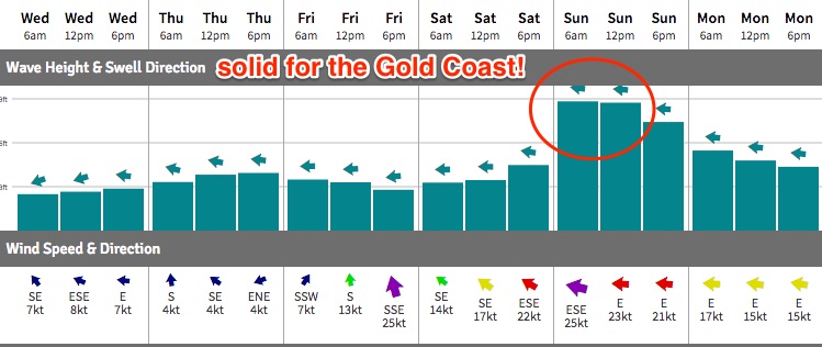
Best Days: Thurs/Fri AM: fun peaky E'ly swell across the beachies, with generally light winds (S'ly winds will bump up the surf during Friday). Sunday: large E'ly swell but with complex winds, likely onshore at most locations. Protected spots only. Wave heights and wind speeds easing Monday onwards.
Recap: Wave heights have built slowly across Northern NSW and SE Qld over the last few days, with 2ft+ sets on offer Tuesday afternoon and winds swinging to the S/SE. Surf size has pushed more around the 3ft mark today though winds have been quite tricky at times - for example right now the Sunshine Coast is clean with light variable winds (having picked up 108mm of rain last night!), the Gold Coast has bumpy conditions under a moderate NE'er, Byron Bay was fresh E’ly all day but is now light W/NW, Yamba is light S/SW (and has had 108mm of rain since 9am!), and Coffs Harbour is moderate W/SW (and has had 113mm since 9am, and a further 58mm last night - that’s 170mm in around 24 hours..!!). In fact many locations across the Northern Rivers have picked up 150mm or more in as little as three hours - it’s a very unstable troughy pattern.
This week (Mar 16th - 17th)
A near-stationary high pressure system across the south-eastern Tasman Sea and a broad trough stretching along the East Coast are driving fresh E/NE winds into SE Qld and Northern NSW. This fetch is primarily focused towards southern NSW but the trailing end still extends a reasonable distance back underneath New Caledonia and will continue to supply fun sized E’ly swell over the coming days.
Fortunately, the trough is dragging southwards and in doing so is weakening the pressure gradient across the coast, which will result in light variable winds across most coasts on Thursday. However the trough will form a low off Southern NSW overnight Thursday and into Friday morning, which will drive gusty southerly winds across Northern NSW throughout Friday: earliest on the Mid North Coast, with an early-mid afternoon arrival in Northern NSW and a late afternoon arrival across SE Qld.
Thus, open beaches will be your best bet on Thursday (also Friday morning in the north), with protected points and sheltered southern ends a better option on Friday.
As for surf, we’re looking at a small increase from today into Thursday though not much, most open beaches and outer points will however around the 3ft mark with occasional 3-4ft bombs at reliable swell magnets. If anything, expect slightly smaller surf across the Sunshine Coast due to the source of this swell. Slightly larger waves are possible across the Mid North Coast as the fetch will be better aligned towards this region.
Our surf model has a slightly easing in the size department through Friday though I’m not sure if I agree with this sentiment. The swell source is stationary with no major deviations so I’m inclined to think it’ll fluctuate in and around this size range both days (if anything, with a slight lag Thursday morning). However keep in mind that the swell is only localised, short range energy so it won’t be terribly strong and will be tidally susceptible too.
This weekend (Mar 18th - 19th)
The weekend’s looking somewhat dynamic.
A rebuilding high pressure system in the eastern Tasman Sea and will interact with a broad region of low pressure across the Coral Sea from Friday onwards, firming the existing ridge between the two. More interestingly, a developing E’ly dip between Northern NSW and New Caledonia on Friday is expected to retrograde westward, building upon the (likely) fully developed sea state generated by this week’s near stationary E/NE infeed.
Additionally, the westward movement of this dip will further enhance wave heights from a theoretical norm.
Models push this system up against the Northern NSW/SE Qld during the weekend and as a result we’re looking at a rapid increase in surf size throughout Saturday ahead of a peak on Sunday.
At this stage Saturday morning should persistent in and around the 4ft mark at most beaches ahead of a mid-late afternoon spike in size, however Sunday could see easy 6-8ft surf across exposed coasts. Slightly smaller surf is likely south of about Yamba owing to the fetch's alignment towards SE Qld and Far Northern NSW.
The main problem with this pattern will be the local winds, which will generally hold from the E/SE, limiting surfable options to a handful of protected locations (and on the Gold Coast, that single surf spot - Kirra - will probably be occupied by the Quiksilver Pro).
However it is worth pointing out that we often see the formation of local, microscale systems embedded within the broader synoptic pattern which could result in some locations seeing more of a S/SE airstream (thereby favouring the points).
Anyway, let’s take a closer look at the specifics on Friday - but for now it’s looking like a solid, wet and windy weekend of waves.
Next week (Mar 20th onwards)
The E’ly dip associated with Sunday’s large swell increase is expected to dissipate throughout the day, which will in turn slowly ease the pressure gradient and drop wind speeds and therefore surf heights from Monday onwards.
That being said, Monday is likely to kick off in the 4-6ft range at exposed beaches (smaller at protected locations) and although easing in strength the winds are likely to remain from the E/SE quadrant. Wave heights will probably be smaller south of about Yamba.
The ridge is expected to remain in place through Tuesday or Wednesday which means plenty of reasonably solid, residual swell through the middle of the week (4ft or so in the north, a little smaller in the south) however a redeveloping troughy pattern across the NSW coast during the week will probably swing the winds around to the E/NE from Tuesday onwards. No great strength is expected, but it’s worth pointing out that this direction will be pushing close to the devil wind for the region’s right hand point breaks so it won’t be very welcome - even if it’s only light to moderate.
Aside from this, the longer term synoptic pattern maintains little deviation away from this setup, suggesting more trade swell through the second half of next week and the following weekend, though size and quality is hard to ascertain at this early stage.
Elsewhere, a steady stream of Southern Ocean fronts look like they’ll be too zonal (west-east) in alignment to favour Northern NSW’s extreme south swell window.
All in all we have a very active period ahead.. see you Friday for the latest!
Comments
All in all doesn't sound to exciting, what a rubbish season so far.
At least the Quicky might have some bazzars
Not exciting?
After the last four months, I'll take any forecast showing more than two consecutive days without northerly winds as ticking the "exciting" box.
What happened to the weekend forecast!? All been pulled back dramatically. Having said that I'm prefering the look of the updates.
Yeah models have aligned the fetch south of the border. But, it's still early days. A lot can happen in a couple of model updates.
Northerly or southerly, onshore is onshore, makes no difference up here unless you want to join the circus at Noosa at least when it's a light NW it opens up the beaches
Old mate laying into a nice bottom turn at The Alley this morning. Decent lines too!
What a strange sand setup for the Alley
25kt ESE is now 10kt ENE for Sunday. That's a big change. It would be good to see the worlds best surfers at Kirra if it's pumping on Sunday. Is it going to happen..
If the winds going to be E/NE on Sunday I can't see them moving to Kirra. it will be onshore there and smaller in E/NE wind, so why would they go through all the hassle of moving for onshore smaller surf. And forecast has downgraded size for Sunday also. best chance is for lighter winds in amongst the rain on Sun. They'd be best suited to trying to get through as much today and tomorrow as they can and leave Sunday morning for the finals only...to wrap it up on Sun morning before the winds freshen. Say Qtrs, Semis and Final kickinng off 7am Sunday.
Big changes across the model guidance in the last 24 hours. Looks like the fetch will be aimed into the Mid North Coast, so 6-8ft surf from Seal Rocks up to Coffs, but grading smaller as you head north from there.
Looking forward to the latest model updates this afternoon.. nothing like a complex outlook when there's a big international audience tuning in too!
How's Currumbin looking right now too?
Don, please allow me to indulge further discussion on the E/NE wind direction at Kirra.
Yep, this is super pedantic. But I love this level of analysis. So bring it on!
I reckon E/NE is workable at Kirra, if it's not too strong. Sure, the surf won't be great, but if it's 10-15kts or less, and the swell is solid - say at least 4-6ft outside (i.e. smaller at Kirra) - then I reckon Kirra is a good option for the event (sadly it looks like we may not quite reach this size range on Sunday).
My reasoning is that whilst an E/NE flow is technically onshore at Kirra, it is offered a partial degree of shelter from the combination of Point Danger and the outer Snapper bank (which, at 4-6ft and above, can break up to a couple of hundred metres wide of the point). It usually washes through until about Rainbow Bay before filling into deeper water. The surf then reforms through Greenmount, Cooly and Kirra.
This means that any onshore bump from a 10-15kt E/NE breeze is effectively ironed out through post-Rainbow, leaving Kirra kinda clean on the face, if a little lumpy through the lineup.
Preferably there's a reasonable degree of south in the swell direction too (i.e. E/SE) so that the south-north current is activated, which also assists in smoothing out some of the bumps.
So, the distinction needs to be whether the wind direction is E thru' E/NE, or if it's more E/NE thru' NE. The former is workable IMO, the latter would be markedly different and probably quite choppy.
It's a small difference but when assessing the forecast potential I reckon it's a valid point.
Thoughts?
Don't disagree with everything you've said Ben. Disagree on a couple of points (of which SD has said them below). At the end of the day, if it goes E/NE wind, I can't see them packing up camp at Snapper and relocating to Kirra, even more so now the swell is forecast to be smaller.
But as SD has also said....it's a dynamic system and can change quite quickly between now and Sunday.
Do you want me to burst your bubble, Ben ? lol
Nahhhhh.... The ene is the jellyfish shit wind..... The worse possible wind for all of se qld... In a ne for qld, a couple of pockets on the sunny coast, and a couple of certain islands have breaks that actually get quite good..... But the ene is onshore for everything...
Secondly, Kirra is a barrel.... It aint Bells.... 10 to 15 knots fucks that.. Crumbly barrels peeling way too fast and shutting down.... Your theory may stand up in 12 to 15 second six to eight foot.... Faster swells and more ironing out in the gatta bay.
BTW tomoz looks real good..... And I wouldn't write off the whole of Sunday just yet... Quite an unpredictable system.... Pressure gradient at this stage looks very slack fot Sunday morning.
I haven't written off Sunday. Just disappointed it won't be big.
Looking forward to paddling out at Kirra in the E/NE breeze too! Haha.
Btw, the system ene of NZ is kicking up 30K plus..... Quite an extensive area too. Possible 3 to 4 foot at 10 to 11 seconds around monday tuesday..... Then there's another possible short ranger on the 24th 25th with maybe better winds too.
Kirra ain't kirra. Even in 1989 surfing kirra in east north east wind was okay on mid to high tide especially little groyne. But now sand really wide and you end up surfing towards north kirra surf club rather than the pub or old healthy bee at most. Surf it at lovers at dbah. But me be heading to the battle of....
Smoking down there.