Building E'ly swells to reach a peak on Friday

South-east Queensland and Northern NSW Surf Forecast by Ben Matson (issued Wednesday 8th February)
Best Days: Most days should have good waves, biggest on Friday. Expect wind affected quality at times on Thursday (in SE Qld/Far Northern NSW) and then through the weekend as the swell eases, though mainly in Northern NSW from northerlies.
Recap: E’ly swells have been building across all coasts over the last few days, with set waves now somewhere in the 3-4ft range across exposed spots in SE Qld and Northern NSW, a little smaller around 2-3ft across the Mid North Coast. Winds have been mainly SE across SE Qld and generally E’ly in Northern NSW (with some variation here and there).
This week (Feb 9th - 10th)
There’s plenty of swell ahead for the coming days.
The trade flow across the Northern Tasman Sea is consolidating into a broad tropical depression across New Caledonia. The models hinted at this scenario last weekend but backed away on Monday, preferring the bog standard trade flow setup. It's swung back in the last 24 hours though.
Although the upside to such developments are a significant increase in wind strength, the downside is that it’s also realigned the fetch into the Coral Sea. So instead of a moderate, elongated fetch aimed ideally within our swell window, we now have a much stronger fetch aimed to the north - resulting in sideband energy across the coast.
And this will result in a broad range of wave heights, with the largest surf expected across the Sunshine Coast.
And to further complicate matters (mainly related to to Northern NSW) is a secondary E/SE fetch in the southern Tasman Sea, slowly moving northwards. This fetch generated ~4ft surf across Southern NSW today and we can expect this energy to build across the Mid North Coast, and eventually the Far Northern NSW coast through Thursday.
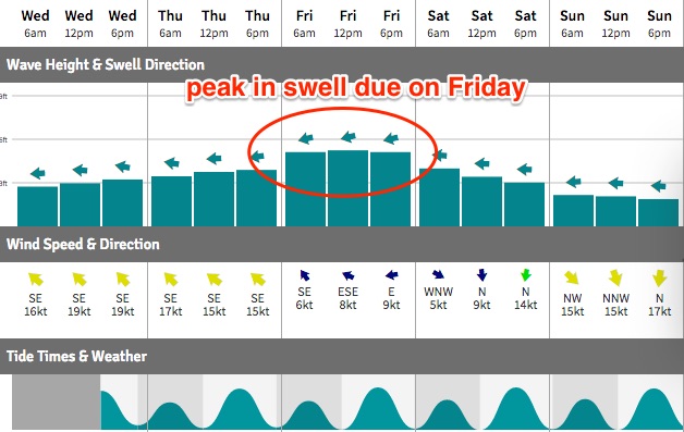
Anyway, surf height predictions for the coming days have ramped up a little as a result of the tropical low near New Caledonia. A slow increase is expected from today into Thursday morning, ahead of a more robust increase across SE Qld late Thursday (possibly just the Sunshine Coast), showing across remaining coasts into Friday. Exposed Sunshine Coast beaches should pick up 4-6ft sets at the height of the swell (on Friday), with 4-5ft+ surf across the Gold and Tweed Coasts, and 3-5ft surf from Byron to Coffs, and slightly smaller surf south to Seal Rocks.
However, Thursday will concurrently see building E/SE swell across the Mid North and North Coasts (from the southern ridge), so 4ft surf is likely at most exposed spots.
Winds are the key factor across the next few days. The ridge will slowly weaken across SE Qld however we will be at risk of fresh winds from this quadrant during the day. It’s likely that light variable winds will settle through the afternoon across some locations (more likely south of the border than north) and N’ly winds are possible across the Mid North Coast.
Into Friday, a weak pressure gradient will result in light variable winds across most regions, freshening from the north again across the Mid North Coast. Weak afternoon sea breezes are expected.
So, Friday morning is the pick of the forecast period with a peak in swell and an early light offshore breeze.
This weekend (Feb 11th - 12th)
Easterly swells will slowly ease through the weekend, and northerly winds will return across most coasts though they’ll probably remain light across SE Qld in the mornings, leading to reasonably good surface conditions for the early surf. The afternoons may however become bumpy, and south of about Ballina there’s a greater risk for stronger northerly winds and thus lower surf quality.
Saturday morning’s looking somewhere around the 3-54ft mark across SE Qld beaches (upper end of this size range across the Sunshine Coast), with slightly smaller surf south of the border. Expect wave heights to tail off into the afternoon and further into Sunday as the northerly picks up.
So, Saturday morning is the pick of the weekend for sure.
Next week (Feb 13th onwards)
A weak trough is expected to move up the Northern NSW coast on Monday and should anchor a small SE fetch into Far Northern NSW/SE Qld’s short range swell window. This should generate some local swell for Tuesday and maybe Wednesday though nothing of any great size or strength is likely.
We’re also still on track for a fairly significant frontal progression through the southern Tasman Sea early next week, which should generate a solid building S’ly swell across Northern NSW through the middle of the week. I’m a little concerned that (at this early stage) that most of the front will be focused up into Victorian waters - in the Tasmanian swell shadow - but we should see at least a reasonable south swell at exposed swell magnets. Let’s fine tune this on Friday.
Otherwise, there's a heck of a lot of dynamic model output suggesting we’ll see the ingredients for a major system taking shape in the Coral Sea or South Pacific some time from later next week through the following week.
But as mentioned on Monday, I’m not confident in the long term model guidance right now because of the active monsoon pattern across the top end and possible Tropical Cyclone in the NW of West Oz, which always throws the models a little skew. More on this in Friday’s update.
Comments
3 to 54 ft Saturday! Big swell range there. Sorry Ben had to do it
Jesus, glad I just got the 7'8 ;)
Love your work Ben !
So anyway, back to the Lennox cam...
Hahaha, been a while since we've had a decent bit of entertainment. Whaddya reckon Ben?
Nice to see a few bigger waves at a protected point this morning Sunny Coast
Bonza!
Sunshine Coast is terrible and will only get worse.
Meanwhile Snapper and Lennox look great on the cams.
Arrghh mass suicide Sunny Coast!
Few decent waves at....ahem, you know where...by the looks. Swell peaks tomorrow you say? Hmm....
Yeah could have seen the peak this arvo up north, you never know i guess....the crowd around Noosa was a sight to behold!
Piss weak move with the lennox cam!
The rumours floating around the NC are swellnet have been approaching houses for quiet some time, with most politely saying fuck off..
The chap who sold out doesn't even surf apparently.
Did swellnet warn him of the ensuring shit fight once it went live Ben?
He's currently the most hated person on the northcoast.
Swell definitely hitting the upper end of the forecast down here...happy days!!
I can't see how a surf cam is going to effect an already crowded/well known surf zone?
Someone had to post it!