Another week of small tricky swells, but with better winds

South-east Queensland and Northern NSW Surf Forecast by Ben Matson (issued Monday 23rd January)
There's only one week left to sign up for the P-Pass competition! Sign up to Swellnet’s newsletter and receive the Sydney, Hunter and Illawarra Forecaster Notes and latest news sent directly to your inbox. Upon signup you'll also enter the draw to win a surf trip to P-Pass for you and a mate. It doesn’t get much easier so click HERE to sign up now.
Best Days:
Recap: Saturday wasn’t much chop across most regions; a developing southerly change conceded with initially small leftovers across most coasts though size built across the Mid North Coast into the afternoon with a new S’ly groundswell. Sunday dawned quite sizeable with 4-6ft sets at south facing beaches in Northern NSW, however SE Qld didn’t see much size due to the swell direction - 3ft+ sets at south facing beaches but only 1-2ft surf elsewhere. The wind outlook issued Friday was pretty close too, with all of SE Qld and Far Northern NSW (except the Southern Gold Coast) seeing moderate to fresh S/SE thru’ SE winds, and locations south of about Yamba picking up lighter W/SW winds. Today these southerly swells have eased a little in size, but are bigger than expected (4ft sets at Northern NSW swell magnets, still present this afternoon as per the image below) and early light winds across all coasts have freshened from the NE this afternoon.
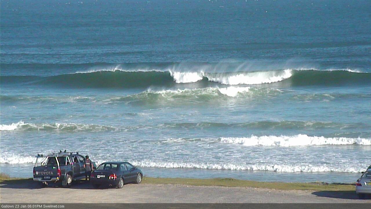
Gallows at Coffs Harbour not looking too shabby this afternoon (watch it live here!).
This week (Tues Jan 24th - 27th)
A developing high pressure system in the Tasman Sea is strengthening S/SE thru’ SE winds across the Northern Tasman and Southern Coral Seas.
It’s a pretty decent kind of fetch: good width, decent length; reasonable speeds and a slight north-west push. However, it’s not aimed very well within our swell window and also isn’t expected to hang around for very long.
So, the upshot is that we’ll see mainly small levels of swell glance the region; it’ll be biggest on the Sunshine Coast and surf size will decrease with increasing southerly latitude. Expect a slow increase through Tuesday, holding into Wednesday before easing through Thursday. Likely size is a peak around 2-3ft across the Sunshine Coast, 2ft across open Gold and Tweed Coast beaches, and 1-2ft south from Ballina.
Also in the water on Tuesday, Wednesday and Thursday will be a continuation of S/SE energy, originating from the polar low responsible for some of yesterday’s and all of today’s southerly quadrant energy. It’s an unusual system on many fronts - firstly, stalled lows in this neck of the woods are rare (most weather systems become absorbed in the high latitude westerly flow), but more interestingly, we’ve seen several incarnations of development, each of which has contributed decent pulses to our region since last Thursday.
Size should hold around the 2ft+ mark at south facing beaches below Byron, however given today’s over-performance (size wise) it’s fair to say there’s a reasonable chance surf size will come in higher.
Conditions look a little tricky on Tuesday as an approaching southerly change will freshen northerly winds about Northern NSW. They’ll be strongest on the Mid North Coast and SE Qld should see a decent spell of light variable winds early morning, but all locations will become wind affected at some point. Aim for a protected northern corner for the best surf.
The southerly change is expected to stall somewhere around Port Macquarie on Wednesday morning, leading to a troughy day and subsequently light variable breeze in most regions from Coffs Harbour north. Wednesday is therefore the pick of the next few days in my books, with a small peaky swell combo and a reaosnable chance for clean conditions.
In fact a lingering trough will hold across the region through Thursday and Friday, so we should see workable conditions each day under light winds. Keep in mind that these “variable” wind outlooks mean that it could crop up from any direction at at time, but at least we’ll be rid of the synoptic northerly (for now, anyway).
Tuesday’s southerly change (in southern NSW) won’t generate much windswell away from the Lower Mid North Coast, however we’ll see a small S’ly groundswell glance the coast on Thursday, originating from the parent low - a very intense but poorly aligned weather system tracking south-east of Tasmania tomorrow.
Most of the swell generated by it will be aimed towards New Zealand, with Australia's East Coast expected to see small glancing energy. South swell magnets south of Byron may see occasional 2-3ft sets at times though it’s a low confidence event so don’t get too excited about.
Also in the water on Thursday (and Friday) will be some small long range SE swell from the aforementioned anchored polar fetch, well to the S/SE of New Zealand. It’ll probably mix in nicely with the pre-existing S’ly swell, and at some locations may create bigger waves as the two swell trains combine.
Friday may also see a small mid-range S/SE swell extending from a secondary intensification from the bottom of the low responsible for Thursday’s swell. No major size is expected from this, but with three possible south swells in the water, plus a light variable wind outlook, surely we can’t go too wrong to finish the week?
This weekend (Jan 28th - 29th)
It’s not shaping up to be a great weekend of waves at this stage.
The trades south of New Caledonia are looking to remain below optimum strength later this week, so only small surf is expected from this source. Otherwise, south facing beaches south of Byron should pick up easing leftover S/SE swell from whatever we see on Friday (early Saturday will be the pick for the biggest waves).
The western Tasman Sea is expected to remain troughy so there’s certainly some potential for the models to upgrade this into a swell generating system, though we’ll need a few days to pin down the specifics. And it’s more likely that it’ll favour southern NSW than Northern NSW (if it develops at all).
Next week (Jan 30th onwards)
We have a return to a broader trade flow across our eastern swell window from this weekend onwards, which is a good sign of more climatic summer swells to come over the next few days. Current indications are for a low, steady increase in E’ly swell from around Monday, reaching a peak Wed/Thurs in the 3-4ft range across SE Qld. More on this in Wednesday’s update.
Comments
Still nothing ... can't be far away
Hope next week comes off....
Fck me, long range GFS just keeps on giving us spring like conditions with a barrage of N/NE winds.
"good width, decent length; reasonable speeds and a slight north-west push"
... and nothing from Gary G? He must be off the grid...
Bit of southerly swell in the water this arvo, hope it hangs around with light winds first up Tuesday
Really fun and clean little beachies with no crowd this morning. Hoping that upwards trend you mentioned Ben comes to pass.
whereabouts are you Benno, we had northerlies at dawn here.
Toward northern end of Sunny Coast. Loving my dim sim in those conditions. I think you might have road tested one at some stage too Freeride?
yeah I did, had tons of fun on it.
Reread that Dim ride report only recently .....was good.
Beautiful clean offshore morning, the sky is falling!
Was only small, but so much fun*
*My standards may have slipped a lot
When long waits for the odd 2fter gets 5/10 you know it's been a bad run lol.
Ben, we still looking waves holding size through til Wednesday? Your models saying smaller surf for tomorrow now
Another perfectly timed photo of the most southerly part of the whole reporting zone to show that there actually IS swell !
Another January day, another nuclear northerly. 20+ knots , hideous.
Going to be a stretch to see surf clean up for tomorrow.
And plenty more of that to come looking at the long range forecast. You'd swear it's Oct/Nov.
So glad i bit the bullet and booked a off season indo trip soon.
huey might be saving it up for an awesome autumn....
Better winds? Northerly blew all night and it's mixed up caca this morning. If this is the best day of the forecast Huey needs a bullet.
Sth wind at Coffs
Looking a bit sad for the Burleigh WQS event
Funny, I just walked in the door from the beach. Was about a foot of short period NE windswell with northerly winds. I'd give it a 1/10.
Ballina wind obs from the same period are saying W winds.......wtf?
I've had trouble with the ballina one before too FR.
Think it can get variable in and around the airport while it's straight N or NE on the coast.
So I just stick to the cape byron one now.