Moderate S'ly and small SE swell to finish the week; next week remains unsure

South East Queensland and Northern New South Wales Surf Forecast by Ben Matson (issued Wednesday 8th July)
Best Days: Thurs/Fri: fun but very inconsistent south swell in Northern NSW with mainly light winds. Fri: Small SE swell in SE Qld. Next week: there's potentially a strong south swell a-brewin' for Northern NSW, but it's way too early to get excited.
Recap: Bugger all surf in SE Qld (even tiny at the swell magnets) however Northern NSW has enjoyed plenty of south swell. Unfortunately freshening SW tending S’ly winds have generally created problems at exposed spots but the mornings have offered windows of cleaner conditions.
This week (July 9 - 10)
No major changes to the outlook for the next few days. The current south swell should continue through Thursday and early Friday across the Northern NSW coast, and local winds are looking to be light and variable again under the influence of a high pressure system slowly tracking eastward through the southern Tasman Sea.
The swell will continue to be lully at times but otherwise should provide good surf at south facing beaches, anywhere between 3ft and occasionally 4ft. Expect smaller surf at beaches not open to the south. We may see a moderate northerly flow develop through Friday afternoon but no major strength is expected. Wave heights will also abate throughout the day.
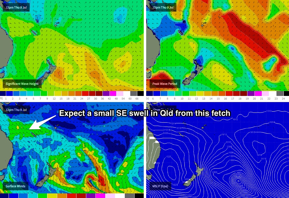
In SE Qld, surf size will increase from the current low point, thanks to a strengthening ridge through the Coral Sea (see chart below). There won’t be much size or quality associated with this surf; it’ll just be short range peaky stuff from the SE that’ll provide surfable options on an otherwise nondescript finish to the week. The Sunshine Coast will see the biggest waves from the source (building to 2-3ft during Thursday, so maybe a little undersized early), with slightly smaller surf on the Gold Coast (2ft+) and then smaller again as you track south of the border. This swell will slowly taper off from Friday afternoon onwards.
Local winds may linger from the S/SE on Thursday - certainly north of Moreton Island - but they’ll certainly ease in strength during the day, and we should see local areas of lighter SW winds, in particular the southern Gold Coast. By Friday we should be back to a light variable pattern probably early NW tending light NE throughout the day but with no major strength.
This weekend (July 11 - 12)
On Monday, I mentioned that the weekend had pretty low potential for surf.
Unfortunately, I can confirm today that the outlook hasn’t changed. I’d seriously considering opportunities away from the coast this weekend, unless fishing or kayaking is your kinda thing.
With no new sources of swell on the cards, we’ll be relying on small residual S’ly swell (in Northern NSW) and SE swell (in SE Qld) throughout Saturday. The early morning should offer the biggest waves (1-2ft open beaches), with an easing trend expected during the day. Conditions will however be good with light westerly winds.
On Sunday, surf size will really bottom out and offshore winds will become quite gusty as a front crosses the coast. As such, the only surfable options - if any - will be at the reliable swell magnets.
Next week (July 13 onwards)
Early next week looks potentially quite sizeable for exposed south facing beaches across some parts of the NSW coast.
A developing low off the Southern NSW Coast has been upgraded in recent model runs, although it still doesn’t quite tick the right boxes to be called an East Coast Low (progged rainfall amounts are low, and the system moves eastwards away from the coast, not parallel). As such it looks like being a big beefy Tasman Low.
However, getting a firm grip on the size and timing of the initial upwards swell trend is quite hard, as each model run is moving the position of the low around - and on some occasions, S/SW gales on the western flank have actually been positioned over land, or at least inside the swell shadow of the Southern NSW Coast (thanks the Hunter curve). This makes it very difficult to have confidence in how much size we’ll see at the coast.
Another factor that also reduces forecast confidence is a series of polar fronts SW of Tasmania that the models are suggesting will push up into SE Australia and become absorbed into the broader Tasman Low early next week. This is a great thing for the alps as it’ll dump lots of snow across the barren ski fields, but it also puts a risk of the synoptic flow developing a strong westerly component. This could very well shave a considerable amount of size off projected wave heights through the middle of the week.
As such, right now I’m hesitant to put a size range on the surf for next week until the models are in broader agreement: right now they’re throwing out options from two feet to ten feet. And while southerly swells are always a low percentage game for protected spots and locations north of the border, sometimes exceptionally strong frontal passages - even when poorly aligned - can often produce one day wonders in SE Qld.
So at the risk of fence sitting, I’m gonna give the extended forecast period a few more days to consolidate the data.
But for what its worth, we’re looking at a sustained period of low pressure across the southern Tasman Sea for much of next week, so on the balance the chances of some degree of solid south swell throughout most of this time frame (excluding Monday) remains quite favourable for Northern NSW (yes, that excludes SE Qld at this stage). We just won’t be able to pin down the specifics until Friday at the earliest, that’s all.
See you then!