Thursday and Friday the best of the week

South East Queensland and Northern New South Wales Forecast by Ben Matson (issued Monday 23rd March)
Best Days: Thurs/Fri: small E'ly swell, but SE Qld may suffer under N'ly winds on Thursday (let's hope they tend more NW). Light winds should occur south of Byron tho'. S'ly winds for Friday with protected beaches best.
Recap: Small average waves over the weekend with average conditions. A small increase in trade swell delivered slightly bigger waves later Sunday and into Monday across SE Qld, but on the whole it’s been a big bag of Meh.
This week (Mar 24 - 27)
Not much surf is expected of the next few days. The swell window has remained quiet in recent days so small waves will prevail across all coasts.
Freshening northerly winds are expected both Tuesday and Wednesday except the Mid North Coast which will see a shallow southerly change early Wednesday morning. However, it probably won’t penetrate much further north than about Coffs or maybe Yamba and no major swell increase is expected in its wake.
Tuesday will see light winds early morning in SE Qld but the current small trade swell is expected to ease back in size so don’t expect anything worthwhile here either.
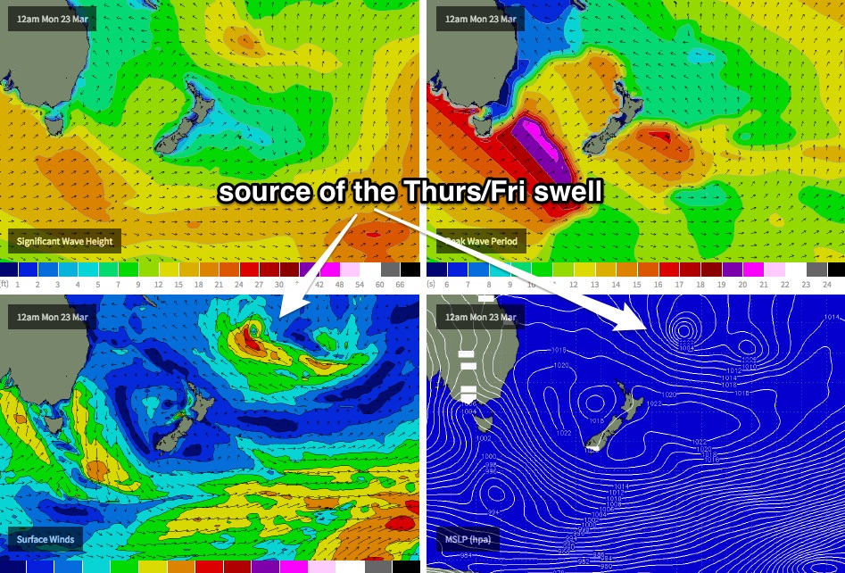
Overnight on Wednesday, the leading edge of a small easterly swell is expected to push through, generated by TC Reuben yesterday and today, way out south-east of Fiji.
This system ended up consolidating a little better than Friday’s model runs indicated, and although the large travel distance will erode a significant percentage of its size, we should see a fun swell across open beaches for a couple of days (building Thursday, early peak then easing Friday), with set waves in the 2-3ft+ range at exposed beaches (smaller across semi-exposed points). Expect long breaks between sets though.
But, the big caveat for this swell event relates to the local winds.
An approaching front across the SE corner of the country will freshen W’ly winds across southern NSW, but a weak trough across northern NSW will freshen northerly winds about SE Qld on Thursday. There’s a chance we’ll see some NW in the wind direction (which will favour some open beaches) but I fear that in general it’ll remain more northerly which will certainly impact wave quality north of the border.
Fortunately for Northern NSW surfers, winds are likely to remain variable on Thursday under the influence of the trough. As such, the best surf options for this swell will be found between Byron Bay and Port Macquarie.
Friday will see an about-face, with steady but slowly easing (and very inconsistent) E’ly swell swell being hampered at open beaches by fresh southerly winds, as a ridge builds along the coast. The semi-exposed points should have small waves but it may be a little marginal at times. Protected headlands will probably offer the best surf to finish the week.
This weekend (Mar 28 - 29)
The Thurs/Fri E’ly swell will continue to slowly ease back throughout the weekend. We’ll still see occasional sets from this source but it shouldn’t be viewed as anything notable.
As for new energy: a developing Tasman Low discussed in last Friday’s notes hasn’t shown any signs of being ramped up in its intensity (yet) by the models. As it is, this was only going to favour NSW beaches but for now the most likely scenario is a small building south swell from late Saturday (Mid North Coast) through Sunday (Far North Coast) with perhaps some 3ft sets at south facing beaches. Very little of this swell will reach locations north of the border. I’ll review this in more detail on Wednesday.
Next week (Mar 30 onwards)
Nothing of interest past the weekend at this stage. A steady procession of strong fronts through the Southern Ocean will maintain very small, long period energy at exposed south facing beaches in Northern NSW, but the Tasman Sea looks like it’ll be quiet (other than the weekend’s low).
The tropics have some interesting developments way out east of Fiji (southeast of Samoa) that could be a possible source of small long range east swell later next week - but we're really clutching at straws here as the travel distance is enormous and even powerful cyclones (were one to form) would need an extraordinary supporting fetch to generate worthwhile energy for the Australian East Coast.
Anyway, prior to any of that (possible, small) swell making landfall, we’ll probably see the trades muscle up across our standard swell window next week, which will most likely be the next source of workable swell, for SE Qld at least. I’ll have more information on that throughout the week.
Comments
Ben..... I am a bit surprised at the predicted strength of the northerlies for sunny coast on thurs by BOM.....
"Thursday 26 March
Winds
Northerly 15 to 20 knots.
Seas
1 to 1.5 metres.
Swell
Easterly around 1 metre, increasing to 1 to 1.5 metres offshore.
Weather
Partly cloudy. 40% chance of showers. The chance of a thunderstorm in the afternoon and evening"
What surprises me is no lighter westerly aspect to the northwind early, and no ne later in the arvo......
Pressure gradient looks very slack early on thurs.......
Feck me, almost a month into Autumn and we're having to deal with N'ly winds fecking up 2-3ft surf, which is the best swell being offered up for at least 2 weeks in Autumn. WTF!!!!
Fair call DW, IMO its been shit to say the least, maybe in a month's time it might change!
Bring on winter with westerlies and ECL's;)
Jesus christ, welly...... You're a hard, hard man. ;)
Cyclone Ola.... Good waves.....
Then that "amazing" 2 weeks of trade swell...
Then a big pulse thanks to a Marcia/trough/tradeswell combo.. Some were saying best Kirra EVA!!
Yeah ok... A bit of a flat spell thru the quicky..
Then Pam.....
Now some 3 foot beachies on the way after the pam swell died last wed'.......
You're a hard, hard man, Mr wellymon............
Hey yeah you are kind of right.
But I hate surfing the Cooley ways:) Too many people rather surf beachies to my self and a few others
Best surf I ha for 3 days in row was during the flat spell with the Quickie on a remote island and flawless head high peaks with no-one around.
Thats why I'm saying bring on Winter weso's and 2-4 fters and barell time on the remote island;)
lol, yeah I know what ya saying mate... I used to like late april/may up there, cos the cooler mornings make the trendy summer crew thin out.. And you can still get rogue east trade swells, plus south swells from autumn lows off south nsw....
Couldn't agree more Welly!!!
So you reckon 15 to 20 k northerlies are correct for thurs, don? All day?
Not gonna comment on that one SD. Masses can work that out for themselves.
Hmmmmm.... Changing your name to tricky dicky ;)
2-3ft with the odd stray 3ft+ bomb set this morning along the SC where I surfed. Slightly wind affected but was actually better than it looked.
Yeah seems a little eariler than expected Don, Byron Bay spectral looks real nice as well. Distinct groundswell and trade-swell traces.