Continuation of southerly swell

South East Queensland and Northern New South Wales Surf Forecast by Ben Matson (issued Friday 19th September)
Best Days: Sat/Sun/Mon: plenty of south swell for Northern NSW but tricky winds (likely to be brief windows of opportunity early mornings, mainly Saturday). Don't expect much in SE Qld. Mon: Slightly better surf prospects in SE Qld; small peelers on the semi-exposed points under a fresh SE wind.
Recap: Mainly small south swell in Northern NSW on Thursday with early offshores tending gusty S’ly then E’ly (?). Very little swell reaching SE Qld as expected. Today has seen a building S’ly swell across exposed beaches in Northern NSW and winds have been a little friendlier. Still not much surf north of Byron though.
This weekend (Sep 20-21)
Southern NSW is a good barometer for incoming south swell across the Northern NSW coast. What’s interesting today is that we’ve seen the peak of the swell arriving after lunch in Sydney, at a time well after the peak was expected (some 12-18 hours later).
As yet there’s no sign of this next pulse at the Crowdy Head buoy (the southern-most data recording device offshore from the Mid North Coast) however late night viewers may see an upwards trend sometime this evening.
And so, the weekend surf forecast maintains the existing regime of south swell, favouring exposed south facing beaches in Northern NSW and offering very little excitement north of Byron Bay.
The Tweed Coast will pull in some of this energy, and to a slightly lesser degree the handful of exposed south swell magnets nearby the Gold and Sunshine Coasts - but if you’re after any juice this weekend you’ll have to aim the surf truck south of Byron.
Wave heights are expected to hold (and fluctuate) in the 4-5ft range at Northern NSW's south facing beaches all weekend. However, beaches not open to the south will be much smaller and surf size will ratchet downwards even more to the north of Byron. In fact most Gold and Sunshine Coast beaches will struggle to pull in much above a foot all weekend. You’ll really need to hit up the swell magnets for anything rideable.
Winds are looking reasonably good for most of the weekend; Saturday morning should see light W/SW winds ahead of a southerly tendency throughout the day however a slowly advancing southerly change (up from the southern NSW coast on Saturday morning) will reach the Mid North and North Coast overnight, and influence proceedings on Sunday. So, a possible window of SW winds early Sunday morning may be only brief ahead of mainly moderate to fresh southerlies for the rest of the day.
Therefore, aim for an early surf on Saturday morning as this will have the best combination of winds and swell. Otherwise, once the wind comes up see if you can find a compromise between size and quality - perhaps some small peelers across the semi-exposed points in Northern NSW.
Next week (Sep 22-26)
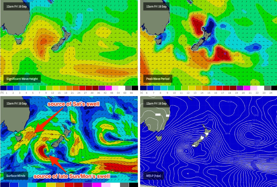
The weekend’s southerly swells are being generated by a series of fronts that have pushed (and are still yet to push) through the lower Tasman Sea. However, the parent low to this progression is developing a secondary fetch near the SW tip of New Zealand’s South Island right now (see chart below), and it’s generating a fresh S/SE swell that’s due on Monday.
Current expectations are that we’ll see solid 4-5ft waves persisting at south facing beaches through most of Monday (with a delayed arrival in the Far North and SE Qld), and winds should swing more W/SW across most regions early morning ahead of a moderate southerly trend from mid-morning onwards.
Also of benefit - the extra SE in the swell direction should allow for a slightly broader spread of swell across various beaches compared to our current (and expected weekend) southerly energy.
Another notable feature of Monday’s swell is that it should have a slightly more positive influence on the Gold and Sunshine Coasts. Although the early morning may start off small, we should see rideable, if somewhat inconsistent 2ft waves filter into the semi-exposed points throughout the day. Exposed swell magnets should rake in 3-4ft sets at times from this source.
Also in the mix on Monday (exclusive to SE Qld) will be a small trade swell generated by a strengthening ridge through the lower Coral Sea from Sunday afternoon onwards. However, the accompanying gusty SE winds will unfortunately render exposed spots bumpy, which is a shame as they’ll be picking up some useful long range S/SE groundswell. So, aim for the protected spots for a small wave.
Monday’s swell will then slowly ease from Tuesday onwards.
Elsewhere, there are no significant swells on the card for the rest of the week at this stage - model guidance has a large blocking high in the Tasman all week (but without any useful tropical developments in our eastern swell window). This high will steer a series of intense polar lows well south of our far southern swell window - we’ll probably see small long period lines from this source all week (exclusive to south facing beaches in Northern NSW) but no major size is expected.
Long term (Sep 27 onwards)
Nothing significant on the charts beyond the end of next week either. There’s a suggestion for a frontal passage through the lower Tasman Sea next weekend (which would lead to a renewal of mid range south swell) but it’s too early to call. I’ll have an update for you on Monday.
Comments
This reads like a swell report for Lennox, not SE Queensland.
Its a SEQ/ "northern" NSW forecast. It pretty much covers everything from seal rocks to double island point or Fraser?
edit: More discussion in Wednesday's notes on this
http://www.swellnet.com/reports/forecaster-notes/south-east-queensland-n...
I think it's also a case of reporting where there WILL be swell, which is currently not applicable to SEQ.
If it was SEQ only, then it would be a pretty sombre forecast...
S/E QLD spring blues.so where does the keen young [ish] Queenslander go for His/ Her fix?Do tell,Phillipines,late Indo,where?
Thanks Ben. It's great to be able to get an overview so easily, otherwise it would be the BOM and extrapolation. Coupled with local knowledge I nearly always get good waves. Such a change from the days when I used to drive down to my local (grassy head), see shit waves and drive home. Thanks Bro.
"Wave heights are expected to hold (and fluctuate) in the 4-5ft range at Northern NSW's south facing beaches all weekend. However, beaches not open to the south will be much smaller and surf size will ratchet downwards even more to the north of Byron. In fact most Gold and Sunshine Coast beaches will struggle to pull in much above a foot all weekend. You’ll really need to hit up the swell magnets for anything rideable."
Tweed Coast exposed backbeaches were 2ft on Saturday, however the forecast model had Cabarita SF magnets at 4ft. Did the swell come in under-size or did some places south of Byron see 4-5ft?
I would have expected 2-3ft there this weekend (did you read the paragraph above the one you quoted?). Haven't had a chance to run through much of the weekend's obs yet but I've detailed before that our model does overcall south swells across the Tweed, Gold and Sunshine Coasts. So the 4ft call would have been an overestimate IMO.
For what it's worth, the surf was thumping in Sydney all weekend (esp Sunday).
"For what it's worth, the surf was thumping in Sydney all weekend (esp Sunday)"
Didn't want to hear that at all!
I guess its just a little tricky to interpret when the analysis isn't aligned with the raw model data. Is there any way to tweak it down a notch for the Caba report?
It's not easy to 'tweak it down' for a few locations, because the problem only occurs during southerly swells of a specific origin, and displaying a particular period range (south-east, east and north-east swells are fine; long period S'ly swells are also fine).
We are trying to find a way to improve on the forecast output under these scenarios - however all model forecasts will always have their flaws. As such we'll try to plug the gap in the extended forecast notes.
So to narrow it down for my future reference (cause I am always watching out for south swells on the forecast & trying to determine the exact resultant size of a sth swell on a well exposed tweed backbeach)
As a rule of thumb would it be safe to say that:
anything dead S or SSE & sub 11 secs should be backed off a few notches from the model?
Yeah that's a reasonable rule of thumb. I'll try to detail it in the notes too.
Cheers Ben sounds good.