Rapidly improving NE swell Sunday, fun and easing Monday

South East Queensland and Northern New South Wales forecast by Craig Brokensha (issued Friday 15th August)
Best Days: Sunday mid-morning onwards, Monday, Wednesday and Tuesday mornings in protected spots
Recap
Fresh SW winds limited options across the North Coast yesterday with a reinforcing S'ly swell to 3-4ft at exposed south facing locations. Protected locations fared best but the swell was much smaller here.
A drop in swell has been seen today with lighter offshore winds across both regions, but not offshore enough to fully clean up south swell magnets.
This weekend onwards (Aug 15 onwards)
One final pulse of S'ly groundswell is due across the coast tomorrow, generated by a very strong polar front pushing up and into New Zealand yesterday while generating a fetch of severe-gale to storm-force SW winds.
While not ideally in our swell window we should still see good levels of side-band S'ly groundswell energy spreading up and into us, keeping inconsistent 3ft sets hitting south facing beaches all day tomorrow on the North Coast (tiny on the Goldy).
Winds should be variable early across the North Coast, but the Goldy looks poor with a freshening E/NE'ly already in at dawn and this will strengthen further during the day, kicking up an afternoon increase in NE windswell 2ft+ across open beaches.
These onshore winds will be related to a deepening inland surface trough slowly moving east towards the coast, squeezing the western flank of a strong high in the Tasman Sea.
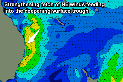 As this trough gradually moves towards the coast a strengthening fetch of NE winds will be aimed into us, kicking up moderate levels of NE windswell through Sunday.
This should reach 3-5ft across north-east facing beaches on the Goldy and North Coast through Sunday morning (easing a touch later) and conditions look to improve rapidly from Saturday's mess as winds swing offshore with the trough moving offshore. Remaining open beaches will be smaller, with even smaller waves at back beaches.
Early may still be a little dicey with N/NW winds, but a swing to the W/NW is due through the morning, quickly ironing out any lumps and bumps, creating great peaky waves across open beaches.
The trough will drift south with a fetch of E/NE gales on its south-eastern flank just remaining in the North Coast's swell window Sunday evening, while a smaller fetch of NE gales feeding into its north-east flank will be more aimed towards the Goldy.
This should keep fun waves hitting open beaches into Monday morning but it'll be on a steady drop, easing from 3ft on the Goldy and 3-4ft on the North Coast down to 2-3ft through the afternoon under excellent all day fresh W/NW winds.
Come Tuesday there's not expected to be much swell leftover as offshore winds continue.
Now, this won't be the end of the swell from this system as broad low pressure system will form in the trough through Monday in the Southern Tasman Sea.
This low is forecast to project a broad fetch of strong to gale-force S/SE winds up the East Coast Tuesday, weakening as it pushes up past the Goldy Tuesday evening.
A fresh pulse of S/SE swell is due off this system not until after dark Tuesday, peaking Wednesday midday/afternoon to 4-6ft across south facing breaks on the North Coast, 2-3ft on the Goldy into the afternoon (bigger on the Tweed).
Winds will however be poor with a fresh to strong SW tending S/SE breeze Wednesday and then S/SW to S/SE winds as the swell eases Thursday.
Longer term a slow drop in SE swell is due into the weekend, but we may see some new short-range E/SE swell developing across the region as a new high moves into the Tasman Sea, with a strengthening ridge on its northern flank. More on this Monday though. Have a great weekend!
Comments
Some impressive rotation of the inland low on this image.
http://realtime2.bsch.au.com/wv_sat.html?region=aus&loop=yes&images=12&a...
Awesome, great link Don!
I reckon, thanks Don.
keen as for a NE novelty swell this Sunday
Strange for this time of the year.......?
ooooohhhhhh Climate Change, thats right.
No Welly ... it's just the weather!
It's pretty low period stuff and it'll take a little while on Sunday for the wobble to iron out I reckon. Sunday arvo def looks better IMO.
Sunday arvo could be real fun Don, it'll be pot luck on bank/swell direction combo
It's pretty low period stuff so I wouldn't think the banks need to be that great in order to get some fun peaky conditions along the open beaches.
Yeah I'd agree with Don, don't need any decent sandbanks with peaky swells like this. Just need at least some sand for the swell to break on.
Bounce back from the failing Niño.
From the 14th onwards, we are going to see a good flow of moisture coming from the east, along with that "permanent" winter inland trough sitting behind the great divide...... The unfortunate thing is no decent upper level infeed from the Timor sea.... However, as that week progresses, thing may take a turn for the better. If we start to see widespread rain around the St george Region of Qld say on the 18th/19th, that will increase the chance of an ECL dramatically....
At least more easterly trade swell is a given, with wind of course......
Nice work S/D,i think it was 2 days later local BOM were yabbing about this on the radio,mostly as a rain event.Bit of E-NE fetch developing now off Frazer,but the swell is junk here on the Sunny Coast.Hope We see some action this arvo.Onshore is good,keeps the crowd down.
Cheers, Tobemeister..... What'll happen is you'll get one of those "short" 3 foot ene swells with an insane sweep for a such small swell..... As has been written by craig, it will clean up on sunday......
Probably 3 to 4 wave sets, with each wave having a distinct peak.... Waves will be stacked quite close together........ The second set wave's peak will be slightly further south than the first set wave.... The third set wave's peak will be slightly further south than the second set wave etc...... The peaks will also have a north to south shifting quality about them.... You the type of swell I mean, Toby? The lefts will have an ok take off, then fatten out...... Hop hop hop..... section....... fatten..... hop hop hop.... section.... fatten... hop hop close out...... The rights will be really short, but hollow and bowly.....
By Monday arvo, it'll be gone...... But use this as a loosening up session for the south swell as the low heads out to NZ..... It wont be "all time", but it will be there....
That is the most detailed surf forecast I've ever heard in my life Sheepy. If it's correct your a legend. So do you think the Coopers tap or the XXXX tap will be colder next Friday at Coolum SLSC ?
The least popular beer, blowin..... Been chilled for ages..... Minimal stock rotation/replacement.... ;)
Mate, it's like shelling peas.... This is a typical ne - ene "wound swell"... Not quite a windswell but not quite a groundswell lol......
Seen hundreds of them..... You either have a great little sesh if you get in sync with it, or you end up frustrated.....
You're a god to me. The least popular beer ( smacks forehead) of course ! Except for when it's too unpopular....I'm pretty sure there's a keg of Fosters that's been chilling at the pub up the road for about 30 years now.
Yep, the size is looking a little smaller than forecast yesterday. Trough moves off earlier and drifts south quicker, so probably 3-4ft tomorrow and then rapidly easing from 2-3ft early Monday.
yeah.... And I think the bar graph for eastern tassie is undercooked..... Which is a good thing ;)
Yeah I'd say 3-5ft at the peak. At least 3-4ft in any case.
I think Monday morning will offer the best conditions personally. May not be as big as Sunday arvo but after having all Sunday arvo/night blowing offshore, Monday morning will have some super clean fun looking peaks on the open beaches.
SD with the only swell we've had up here for ages being from the south I think the banks will handle the lefts fine (ie I don't think they'll be fat at all). Particularly as the period draws out somewhat very late Sunday and more so into Monday.
Just the nature of that type of diagonal hitting close range swell, Don.... left beachys- hollow takeoff, chandelier into deep water off bank,,,,,, fat section as wave regathers,,,,, throws again,,,, another chandelier,,,,,,,, ad infinitum......
Rights will be short and hollow....
Sort of like a little mini margs over sand lol.......
Later Sunday will be the pick Don, it's a fresh and gusty change and it won't take long at all to clean up. We see these systems all the time down here during summer and they really do clean up rapidly.
What about Southerly flank? Should produce some good swell for Tuesday
Yeah will do Mick, but with poor winds. Late Sunday/Monday down around Sydney the pick, more so Monday I reckon as the change is coming later now.
Love the weather calls from all the boys, Cheers
I nearly got my dick finished today before I go back to work, Thanks Mr Tarp you were a great help today, will finish off when I'm back ;)
Hope everyone has good waves.... Bastards;)
Great week, love building shit on the forever deteriorating house built by a peanut builder:)
That's a great looking dick you've got there Welly. I hope you're wife appreciates all the effort you put into your wood...work.
Classic, as my neighbours wife come around today and loved my new dick.
Hope it's hard wood
Hardwood and built to Yowie proof specs.
Aye
"Great week, love building shit on the forever deteriorating house built by a peanut builder"................. mmmmmmmm....... Peanuts......... :p
good calling sd
.
@ hours of looking
Happy little Fitzy here too. 4 water tanks full, 20,000 gallons and a few fun waves :)
I'll give it to you SD, well called.
Nice dick too Welly, I hope your wife is going to help rub some oil on it to protect it.
Great rain last night, same Fitzy x2 full tanks ;) Happy bathers now.
Geezz Fitzy you must have some roof area for 20,000 gallons.
how much rain did you get Fitzy?
your in CQ aren't you?
92mm over the last 2 days. With the house and 2 big sheds, big water catchment. Agnes Water Steve.
How did you guys fair down there, looked good on the radar.
I reckon last night up here in the hinterland we got a at least 150-200 mm
Yeah Ftzy a big catchment helps for sure, 10,000 gallons for sure over a few days but last night did it ;)
I don't have a rain gauge but I kind of know looking in the tanks and listening to it fall on the tin roof.
Might have too google the rain fall last night
"It's pretty low period stuff and it'll take a little while on Sunday for the wobble to iron out I reckon."
Don, you are like a clairvoyant.
" ...Sunday arvo def looks better IMO."
Let's see shall we, I'm off for a big brekky, so no surf till that's digested ;)
Steve, we got bucket loads of rain here last night. I'm guessing you did too?
"Nice dick too Welly, I hope your wife is going to help rub some oil on it to protect it."
Yeah, especially since you've gone and made it all that much wider for her.
When will photo reports be back for the Gold Coast?
Fitzy here at Lennox we've had close to 200 mm so far this August, over 120mm for this event. Extraordinary for August.
Cheers, FR..... Another thing to note, and I'll use laymans terms, is the ne' feed on the back of the low will leave a "snail trail" of lower atmospheric moisture so to speak, over the ocean region where it blew ( 10s 150e - 10s 165e x 35s 150e - 35s 165e)......
Now, as the low moves out, and the southern flank pushes colder se winds back into the "snail trail" lol, it'll be worth watching this area......I'm talking 22nd onwards..... Potential troughs/disturbances from warm snail trail remnants, and colder tasman air.... "mix and stir"....... No "inland low" scenario..... More of an "unseasonal" ocean setup...... Potential big east fetch with embedded troughs....
Yep that's what I'm seeing to
Well we had some absolutely fantastic surf today Nth Sunny Coast,easy 4 ft on the sets at the open beaches and some bigger sneaker sets amongst it.Cleaned up early and most places were pumping all day.Must have been a good fetch,there was some power about the swell.
Tobym, wow totally agree and then some. So surprised by size, power, and zero people. Where I was, was as throaty as I can remember ever seeing it. But the sweep.... Damn
spot on prediction sd. Heres one of the open beaches. Sweep was the killer so many of these drainers so hard to stay on the spot. http://tinypic.com/view.php?pic=hw0dgn&s=8#.U_BwusUmWuJ
Cheers, rees0.... That photo is sweet....... if you look closely, one can see the second set wave, and how the peak is slightly shifted to the south of the first set wave.... And I bet that barrell chandeliered onto a fat dead shoulder..... I was sent a photo of a really good right bank on the sunny coast yesterday, rees0..... That's what I used to hunt for on these types of swells, being a lazy guy who hated sweeps lol.....
Going right would negate the sweep.... And paddling back out, i'd always paddle ene.... The sweep would take me straight back to the take off spot.... hehehehe......
Feck that's a sic pic.
So looks like the call of Sunday arvo being the pick was spot on, seen some amazing images from the North Coast. Was epic down here as well!
Sunday was the pick up here also. Had some size, but in particular, had some grunt.
Swell peaked between 9-12......so Sunday morning was the go here. By the arvo, high tide and dropping had flooded it a bit. Epic day on the beachies....hard to believe it was called a 3/10 on the surf report. Blind Freddie could see an epic day of beachie bazzas was in the offing.
It was probably a 3/10 at dawn Steve. Conditions improved drastically by late morning.
By 8am, when the second report was posted, conditions were already on a rapidly improving trajectory and like I said, blind freddie could see an epic day of beachie barrells was in the offing.
Wouldn't have taken much surf knowledge to know it was no 3/10 day.
Using the same logic today in Sydney Steve, it was 8/10 on the Northern Beaches this morning, but seeing the change has swept through and it's all over, Ben should of put 2/10 as the rating??
The dawn report stated that while conditions were lumpy early, a shift in wind to the west would see improving surf during the day.
And then the Ballina reporter stated in his report that conditions were improving with the westerly wind starting to kick in.
Sure it could of been a bit higher than 3, maybe 4 or so, but the photos didn't look anything special when the report was updated.
Up to you how you run the logic Craig, but I would have thought if an epic day is very obviously in the offing....hell it was called in the forecast notes... then the rating should reflect that.
By a similar logic, if a bad wind is about to blow it to shit, then the rating would reflect that to, as well as the written content of the report.
Just makes SN look silly and incompetent when ratings like that get thrown out. Especially when they run counter to the forecast notes.
I'm with Craig on this one Steve. The report is just that. A report of the actual conditions at the time. The forecast is a forecast of what's to come. If the surf is shit at the time the report is take then the score should reflect the actual conditions whilst the words can talk about what's expected to come.
I think most surfers on the day would have disagreed but thats showbiz.
Hey guys, just wondering your thoughts for surf on east coast for next week, confused west aussie. Cheers.
4-8ft plus east swell .......Sheepdog Donweather and Freeride are your long range forecasters
Erm, and me and Craig too. Y'know, the ones providing the platform?
Ben - http://www.swellnet.com/reports/forecaster-notes/south-east-queensland-n...
Just send me a cheque...... I'm not into internet banking...... ;)
ps - funny old setup next week aye...... Trough situated in quite high hpa..... But trough nonetheless....
pps - east tassie pumping....... Gotta love commitments....... :/
Ha! Well played and spotted.
LMAO re: your platform comment Ben!!!!
Thanks udo.
Gday dreamer.... Yeah WA is a bit like a factory..... Roaring 40s swell conveyer belt just churning out waves....... Check winds and off you go.....
East coast is more like a mad scientists lab....... Add some of this - a splash of that - oops... no swell..... oh well, I'll mix this with that and a heat together, now hit it with dry ice.... Ohhhhhh waves!!!! Yay!!!! ;) So, yeah, I get why you are confused...... But Ben has next weeks forecast pretty spot on here - http://www.swellnet.com/reports/forecaster-notes/south-east-queensland-n...
I'd like to add that there will probably be more size on the sunny coast than the goldy....... Winds might be an issue..... I'd say 3 foot east with a pinch of ene....... Often surfed starved locals north of Bundaberg might even get a couple of small sliders........
But keep an eye on the charts dreamer.... That crazy east coast huey scientist still might add too much "stoke", or not enough "pump".... Yet his test tube might even crack over the bunsen burner if causing a vortex!!!! I'd like to see that!!!! lol
GFS's 12z run this morning has backed away from the trough/E'ly dip scenario somewhat. Access G (to a lesser extent) and EC are trending to continue to push it out (timewise) with each model run, which is never a good sign.
Sure we've got swell from either scenario but without the trough/low forming and moving south of us, local winds will be rather crappy also.
with so much instability there, anything could happen with local winds.
Ha Ha thermal I expected a quicker response from the podium forecasters, didn't expect you or Craig to comment long range with it being a little sketchy looking at the moment........fuck youd get some knockers riding you if were even 2ft off the mark.