Solid south swell in the north, but fading steadily mid-week

Southeast Queensland and Northern New South Wales Surf Forecast by Ben Matson (issued Monday 26th May)
Best Days: Tues: strong S/SE swell - get in early for the best winds (points will be dicey tho' with winds out of the northern quadrant). Expect much smaller surf in SE Qld. Wed: easing S/SE swell with freshening NW winds.
Recap: Pumping waves over the weekend with a strong E’ly swell Saturday easing steadily Sunday. Light offshore winds in the morning and sea breezes in the arvo. Sunday also saw a reasonable south swell push up into south facing beaches along the Northern NSW coast that lingered into this morning. A stronger, large S’ly swell is currently making its way along the East Coast (having arrived in Sydney late morning) and is expected to reach the Lower Mid North Coast this afternoon.
This week (May 27-30)
The current south swell is producing some meaty waves in southern NSW, with some exposed south swell magnets pulling in easy 6ft+ sets at the time this forecast was prepared.
We should see a healthy percentage of this size fill into exposed south facing beaches along the Northern NSW coast on Tuesday: swell magnets should pick up solid 5-6ft sets but it’ll be smaller at beaches not open to the south, and freshening northerly winds will generally make a meal of conditions at most spots.
That being said, we should see a period of early NW winds in most locations, so beaches that can handle this swell should offer great options for at least a few hours. Otherwise, you'll have to aim for some protection from the wind.
As for the SE Queensland region, most beaches won’t pick up much more than a couple of inconsistent feet of refracted south swell at best, however (the handful of) exposed south facing beaches will be considerably bigger, somewhere in the 4ft+ range at times. So pick your spot accordingly - there’ll be thumpers on offer on Tuesday if you’ve got a reliable south swell magnet up your sleeve.
From Wednesday onwards it’s a downwards trend into the end of the week. There’ll be great beachies on offer early Wednesday morning - biggest in the north of the state (as the swell dries up from the south) and winds will be NW tending W'ly so it’ll be smooth on top. However there are generally no new sources of energy on the charts so make the most of what’s on offer mid week as it’ll be tiny through Thursday/Friday.
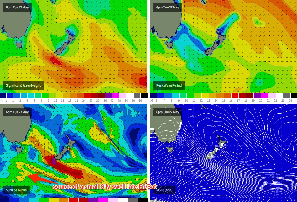
The only possible option that may buck this downwards trend will be found in the Lower Mid North Coast on Friday afternoon. A polar low of only moderate strength is currently forming well south of the Tasman Sea, and a broad S/SW fetch is expected to push up into our south swell window on Tuesday (see chart below), eventually merging with the tail end of a mid-latitude front expected to sweep across the south-eastern states on Wednesday (bringing NW tending W’ly winds).
This system will ultimately track into the New Zealand region by Thursday, however it will have spent at least a day or two in our acute swell window, and will consequently generate a small southerly swell that’s likely to reach the Sydney region during Friday morning. At this stage I’m not confident of the arrival time in the Lower Mid North - and I doubt we’ll see it reach much further north than about Coffs Harbour before close of business Friday - however south facing beaches may pick up a few stray 1-2ft waves at times. Let’s check in on Wednesday to see how it’s tracking.
This weekend (May 31 - June 1)
Not much on tap for the weekend forecast right now. Friday’s late arrival of small south swell (in the south) may provide some peaky rideable options at south facing beaches on Saturday but most locations will be tiny. A moderate ridge is expected to form over the central Tasman Sea over the weekend and this may give rise to a small, short range E’ly swell across the Far Northern NSW and SE Qld coasts on Sunday, but there’s only low confidence for this scenario right now. Wednesday will have more clarity.
Long term (June 2 onwards)
A couple of small systems to keep an eye on for the longer term - a small trough off the NW coast of New Zealand this weekend has potential for a small to moderate east swell early next week, the aforementioned ridge across the central Tasman could maintain small east swell in the north around the same time, and a series of migratory polar lows could supply intermittent long range southerly groundswell for exposed south facing beaches in Northern NSW throughout much of the week. But these are all 'possible' scenarios, none of which are very promising at this early stage. Check back on Wednesday for an update.
Comments
When is the south swell expected to hit the sunshine coast?
Just haven't seen an increase from this morning so just wondering if it's missing the kawana area or sliding past and will have to venture north to get a wave before heading back to work...
In the notes above I mentioned it's only just reached the lower Mid North NSW Coast late this afternoon. Should be up into the Sunny Coast by mid-morning tomorrow, but only really getting into south swell magnets.
Sweet , Cheers for the reply!
Again...http://manati.star.nesdis.noaa.gov/ascat_images/cur_25km_META/zooms/WMBd...
???
Nah, not very well aligned. Maybe a few stray 2ft sets in SE Qld and Far Northern NSW on Sunday but there won't be much in it I reckon.
Interestingly, having mentioned this system as a possibility last Friday, the Monday model runs whisked this system quickly to the east (with zero surf potential), so I didn't mention it. It's now worth mentioning but only in the absence of anything else meaningful.
Yeah, seems as though the WAMS are wigging out a bit for sunday. Sth swell 3ft in SEQ but not on the Ballina graph.
That's unrelated to the South Pacific weather system though.
This issue is due to the way we calculate the surf height relative to the orientation of the coast. We had the same issue with Newcastle (and made an alignment adjustment there that seemed to fix the problem) and I think we'll have to do it with Ballina too.
Only affects south swells in Ballina, everything else is fine.
And by that I mean I can't back track the same swell down the coast. If I look at today's Ballina forecast swell trains (wed 12am. 1.5m @ 12.6s 180S), the same swell is forecast for the Sunny Coast 6hrs later (1.5m @ 12.7s 178S).
Can't do that for the sunday swell though.
yEP, all understood Ben. This sunday's graph seems to be a slightly different issue than the usual scenario. Seems to be materialising out of nowhere on the SC graph. But, the WAMs plot shows the train clearly enough, as you would expect.
Crying shame about that tropical low tucking behind NZ..... But hey, some mysto spots around Fiji, and another couple of island nations will be cranking with a s/e swell.... A rare opportunity for any disgruntled pro's and photogs'....