Weaker swells with average winds

South Australian Surf Forecast by Craig Brokensha (issued Wednesday November 1st)
Best Days: Mid Coast today, South Coast tomorrow morning, South Coast Monday morning and possibly Thursday morning next week
Features of the Forecast (tl;dr)
- Easing S/SW swell tomorrow with mod-fresh E/NE tending S/SE winds
- Small-mod sized reinforcing S/SW swell Fri AM with fresh SE winds, strengthening from the S/SE later
- Small Sat with fresh SE tending strong S/SE winds later
- Small, weak S/SE windswell for Sun, easing Mon with mod-fresh SE tending stronger S/SE winds Sun PM
- Inconsistent, small mid-period S/SW swell for Mon AM
- Variable tending S/SE winds Mon
- Small Tue with variable tending S winds
- Fresh S winds Wed
- Small-mod sized mid-period S/SW swell for Wed PM, easing Thu with light S/SE winds, freshening
Recap
Firstly condolences go out to the family, friends and those who witnessed yesterday's tragic attack on the West Coast, along with the wider South Australian surfing community. We all know the risks but it doesn't make it any easier when events like yesterday take place.
Surf wise, a good SW-S/SW groundswell filled in through yesterday but with choppy conditions across the South Coast that improved into the afternoon as onshore winds eased and sets pulsed to 6ft+. The Mid Coast was a bumpy 2ft in the morning with cross-shore winds, a little more consistent into the afternoon but with a bit more wind.
Today the swell is easing and conditions are cleaner down South though lumpy with easing 4-5ft sets, 1-2ft across the Mid Coast. Sea breezes will spoil conditions across both coasts into the afternoon, though tending S/SE into the evening in the gulf.
This week and next (Nov 2 - 10)
The coming period now looks very average as we see a strong high filling into the Bight, squeezing a trough to the east, resulting in deteriorating and persistent S/SE-SE winds from tomorrow afternoon through Sunday.
There is a window of E/NE winds due across the South Coast tomorrow morning with smaller 3ft+ sets, easing through the day. The Mid will become tiny, easing back from 1ft.
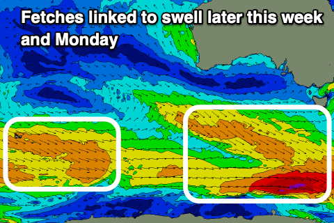
A small reinforcing mid-period S/SW swell should maintain 2-3ft surf on Friday but with fresh SE winds that will strengthen through the late afternoon from the S/SE. This is being generated by W/NW winds moving under the country, on the backside of the low linked to the current swell
This pattern of SE tending S/SE winds will continue through the weekend, with poor levels of S/SE windswell kicked up to 2-3ft or so as the Mid Coast becomes tiny to flat.
Come Monday we're looking at possible variable offshore winds and a small mix of easing S/SE windswell and a background mid-period S/SW swell.
The background swell and another slightly better pulse for Wednesday will be generated by weak but persistent polar frontal activity across the polar shelf over the coming days. Only small 2ft sets are due Monday morning across Middleton, with Wednesday afternoon's likely pulsing more to 2-3ft, easing Thursday.
Winds are tricky with variable breezes on Tuesday due to give way to fresher S breezes on Wednesday, lighter but lingering S/SE Thursday. More on this Friday.