Slow improvement in surf tomorrow, better later week

South Australian Surf Forecast by Craig Brokensha (issued Monday October 16th)
Best Days: Wednesday morning swell magnets down South, Thursday and Friday mornings down South
Features of the Forecast (tl;dr)
- Moderate sized S'ly swell easing tomorrow with moderate E/NE winds ahead of sea breezes
- Small, fading surf Wed with N/NE winds ahead of E/SE-SE sea breezes
- Moderate sized S/SW groundswell Thu AM, easing through the day with N/NE winds ahead of sea breezes
- Easing surf Fri with N/NE tending N/NW winds
- Small W/SW swell Sat with a building windswell. Strengthening W/NW winds
- Weak S swell Sun with strong W/SW tending SW winds
- Easing surf Mon with variable tending SE winds
Recap
The weekend was poor on the Mid Coast with lingering onshore winds and easing surf from later in the week, better down South with bumpy waves on Saturday to 2-3ft, pulsing in size yesterday to 4ft across Middleton with favourable winds for semi-protected spots.
Today a trough has brought strong onshore winds and a localised pulse of windswell to 3-5ft across the South Coast and 1ft to nearly 2ft on the Mid Coast (though weak).
This week and weekend (Oct 17 - 22)
The trough linked to today's poor conditions will move off to the east tomorrow, allowing winds to swing back to the E/NE tomorrow morning with a mix of moderate sized swells.
A moderate sized S'ly swell will be generated by strong S/SW winds behind the trough today, but it'll be a bit all over the place, quickly dropping from 3ft to possibly 4ft off Middleton and 1ft on the Mid Coast.
Wednesday looks smaller and fading from 2ft across Middleton along with morning N/NE winds before E/SE-SE sea breezes kick in (go early).
Moving into Thursday, a good new S/SW groundswell is due. This groundswell which was identified early last week before the system downgraded into the end of the week, now looks quite healthy again. The source is a strengthening polar low developing to the south-southwest of Western Australia today, producing a fetch of gale-force NW winds followed by severe-gale W/NW winds late in our southern swell window.
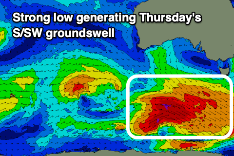
A moderate sized S/SW groundswell is now due, with it peaking Thursday morning to 3ft to possibly 4ft across Middleton, tiny on the Mid Coast and to 1ft.
Winds on Thursday look great with a N/NE offshore ahead of sea breezes, all day offshore from the N/NE tending N/NW on Friday as a trough approaches from the west and the swell eases from 2ft or so across Middleton.
Now, the small pulse of W/SW swell that was on the cards for the Friday looks to arrive Saturday, generated on the backside of the polar low and in our far swell window. It looks inconsistent and only to 1-1.5ft, but with poor, strengthening W/NW winds. This will be associated with the trough moving in, deepening while pushing east, bringing some additional windswell to the mix.
The models diverge a little on the positioning, movement and timing of the deepening trough come low, but it looks to stall south of us Saturday (bringing those strong W/NW winds), shifting to the W/SW-SW through Sunday as it starts to move east.
Moderate levels of poor quality S'ly swell are due across the South Coast Sunday, easing into early next week as the low moves further east. Following this the outlook remains average with funky mid-latitude lows and troughs pushing in from the west. More on this Wednesday.