Large swells to come with average winds

South Australian Surf Forecast by Craig Brokensha (issued Monday October 2nd)
Best Days: Today both coasts, tomorrow afternoon protected spots South Coast, Mid Coast Friday and Saturday, South Coast for the keen Monday morning and more so Tuesday morning
Features of the Forecast (tl;dr)
- Moderate sized W/SW swell building tomorrow with strengthening W/NW-W winds
- Larger W/SW groundswell building Wed (peaking later) with fresh to strong S/SW winds, easing slowly Thu with gusty SW tending W/SW winds
- Large SW groundswell building Fri with S/SE winds on the Mid, light S/SW tending gusty S/SE down South
- Easing S/SW groundswell Sat with gusty E/SE tending S/SE winds
- Smaller Sun with light-mod E/SE tending S/SE winds
- Inconsistent, moderate sized SW groundswell Mon with E/NE-NE tending S/SE winds
- Easing swell Tue with NE tending SE winds
Recap
Tiny surf on the Mid Coast with early light winds Saturday, poor and choppy yesterday as a front moved through. The South Coast was the pick of the weekend with easing 2-3ft sets across Middleton Saturday, poor yesterday with smaller, onshore surf.
Today, conditions have cleaned back up across the South Coast with small 2ft waves for the keen across Middleton, (generated by yesterday's front), 1-1.5ft on the Mid Coast. Winds will remain favourable all day, tending N/NW down South and becoming light from the N'th across the Mid Coast ahead of an approaching trough.
This week and weekend (Oct 3 - 8)
We've got a funky week of winds and troughy weather which will unfortunately spoil a couple of large groundswells.
Firstly tomorrow some small, inconsistent mid-period W/SW swell from a weak front moving through the Indian Ocean is expected, with surf to 1-1.5ft on the Mid Coast and 2ft sets across Middleton (reaching 2-3ft into the afternoon) but with less favourable winds.
Strengthening W/NW winds ahead of a strong but weakening frontal progression moving in across Western Australia will create choppy surf in the gulf (and likely some windswell to 2ft later) while favouring protected spots down South.
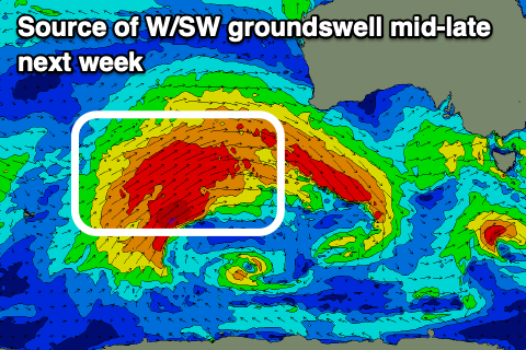
The earlier stages of this frontal progression have generated a large W/SW groundswell, with it firing up to the west-southwest of Western Australia over the weekend.
A fetch of slow moving gales have been generated through our western swell window, with bursts of severe-gales at times.
The groundswell is due to arrive through Wednesday and build into the afternoon, reaching 3ft across the Mid Coast and 4-5ft+ across Middleton, easing from a similar size on the Mid Coast Thursday and 4-5ft down South.
Unfortunately winds will be poor for both regions through the entire swell event thanks to the remnants of the progression moving east, across us Wednesday bringing strong S/SW winds.
The remnants are due to form into a low to our east, stalling through the end of the week, maintaining fresh SW-S/SW tending W/SW winds into Thursday as the swell starts to ease.
Friday should see winds ease temporarily through the morning though likely lingering from the S/SW before a high edges in from the west, bringing strengthening S/SE winds.
The Mid Coast looks cleaner and fun with smaller surf to the 2ft range.
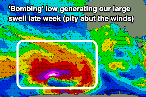
Now, at the same time on Friday we're set to see a large, long-period SW groundswell filling in, generated by a 'bombing' polar low that will form around the Heard Island region today.
The position of this low is much better for the South Coast compared to the frontal progression generating Thursday's W/SW groundswell, with a polar fetch of pre-frontal gales due to give way to much stronger severe-gale to storm-force W'ly winds, south-southwest of Western Australia tomorrow.
The low will weaken while continuing slowly east during this week resulting in a large, long-period SW tending S/SW groundswell that should arrive Friday and build rapidly to a peak into the afternoon. Building surf to 6-8ft is due across Middleton into the afternoon with 2ft sets continuing across the Mid Coast, easing back Saturday from 6ft+ and 1-2ft respectively Saturday morning, smaller Sunday.
Winds will unfortunately remain onshore for the South Coast thanks to the slow moving high pushing in from the west, stalling south of us. This will direct gusty E/SE-S/SE winds across the state on Saturday, weaker Sunday morning and possibly tending E/NE for a short period.

Early next week will be more reliable for an E/NE-NE offshore down South along with a fun pulse of reinforcing SW groundswell, NE on Tuesday morning with smaller, easing surf.
The blocking effects of this high will be seen during next week with the surf due to bottom out into through the middle to end of the week.
More on this Wednesday.