Trickier period to work around

South Australian Surf Forecast by Craig Brokensha (issued Wednesday April 26th)
Best Days: Today South Coast, South Coast magnets tomorrow morning, possibly early Saturday Mid Coast, Sunday South Coast (Mid Coast afternoon), Monday morning South Coast, Tuesday and Wednesday protected spots down South
Features of the Forecast (tl;dr)
- Low point in swell Thu with mod-fresh N/NW winds, tending NW later and strengthening
- Mix of building SW groundswells Fri with strong but easing SW winds, tending W/SW later
- Moderate sized mix of SW swells Sat and small W/SW swell with S/SW winds (possibly S/SE early on the Mid)
- Easing surf Sun with N/NW tending variable winds down South, N/NE tending light NW on the Mid Coast
- Building SW groundswell Mon with similar winds to Sun
- Moderate sized mix of swells Tue/Wed with strong W/NW-W/SW winds
Recap
Great surf continued across the South Coast yesterday with clean conditions and waves to 2ft through the morning, pulsing to 3ft+ into the afternoon with the arrival of a new W/SW groundswell as conditions remained clean and glassy. The Mid Coast was between 1-1.5ft all day and with generally favourable winds.
Today the swell is slowing with clean conditions again down South and easing 2-3ft sets, bumpy on the Mid and to 1-1.5ft.


Options galore yesterday afternoon
This week and weekend (Apr 27 - 30)
After the great run of surf down South, tomorrow will become a little less appealing as the swell eases further from today, dropping from 1-2ft across Middleton under an offshore N/NW breeze, strengthening later out of the NW. Try the magnets if you're keen. The Mid Coast will become choppy and be tiny.
On Monday I pointed out that the change due on Friday was expected to be delayed, but this has been brought forward again with strong SW winds due at dawn across all locations, easing through the day and shifting W/SW later ahead of a secondary approaching cold front.
Swell wise, the front will bring a weak windswell for the Mid Coast, building to 1-2ft while the South Coast should see a mix of close-range SW swell and long-range SW groundswell.
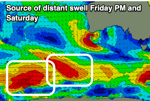
The source of the close-range energy will be a tight burst of strong SW winds under us Friday morning, with the long swell generated by a good fetch of W/NW gales, east of the Heard Island region earlier in the week.
Both swells are due to reach 3ft into the afternoon Friday, with a secondary pulse of SW groundswell due Saturday morning, produced by a better fetch of trailing W/SW gales behind the W/NW fetch mentioned above.
3-4ft sets are due off Middleton Saturday, with the Mid Coast holding 1-2ft as winds remain onshore from the S/SW. There's a chance for early S/SE winds on the Mid Coast but we'll confirm this on Friday.

Sunday looks the pick of the weekend for the South Coast as winds shift N/NW with mid-period SW energy easing from 3ft across Middleton. The Mid will be a little wind affected and likely back to 1ft to occasionally 2ft on the favourable parts of the tide. The afternoon looks cleanest as winds go variable from the NW.
Moving into next week we've got plenty more swell on the way as a healthy frontal system swinging in from the south-east Indian Ocean, then spawns into a broad low. This will see plenty of swell generating fetches moving through our south-west and then western swell windows, building from later Monday but peaking Tuesday/Wednesday.
At this stage the size looks to be in the 3-4ft range across the South Coast with 1ft to possibly 2ft sets on the Mid Coast as winds mostly favour the South Coast. More on this Friday.