Improving waves on the Mid Coast, options down South

South Australian Surf Forecast by Craig Brokensha (issued Friday August 19th)
Best Days: Mid Coast tomorrow afternoon and Sunday morning, South Coast Sunday, South Coast protected spots Wednesday morning, both coasts Thursday, Friday through Sunday next weekend South Coast
Features of the Forecast (tl;dr)
- Moderate sized mid-period W/SW swell for today (peaking PM down South) with strengthening W/NW tending NW winds
- Mix swells Sat ahead of a new W/SW swell into the PM
- Early W/NW tending S/SE winds mid-morning down South tomorrow, mod SW tending lighter S/SW and then variable winds on the Mid
- Easing W/SW swell for Sun with N/NW winds down South and light NE tending mod N/NW winds on the Mid
- Smaller surf Mon with strong NW winds ahead of a SW change mid-late AM
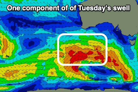
- New moderate sized SW swell Tue with strong S/SW winds, easing and tending W/SW
- Moderate sized SW swell Wed with W/SW winds on the Mid, W/NW early down South
- Easing SW swell Thu with lighter S'ly winds
- Building S/SW swell Fri with N/NE tending SE winds
Recap
Tiny, wind affected waves on the South Coast yesterday with a weak, building NW windswell on the Mid Coast with poor winds.
Today we've got a mix of new W/SW-SW swells in the water with the South Coast due to peak through this afternoon as winds shift NW and strengthen. Size wise Middleton was around 2-3ft this morning with choppy, full 2ft sets on the Mid Coast.
This afternoon's peak in size should come in at a more consistent 2ft on the Mid Coast with 3ft+ waves across Middleton, cleanest in protected spots down South.
This weekend and next week (Aug 20 - 26)
This afternoon's strengthening winds will be linked to a mid-latitude front currently pushing in from the Bight and this will bring some reinforcing mid-period and lower-period energy through tomorrow, biggest and strongest into the late afternoon, easing slowly Sunday.
The Mid Coast should be around 2ft most of the day, not ideal with the morning high tide, building later in the day to 2-3ft. Middleton looks to be around 3ft in the morning, easing though the day owing to the west nature of the new swell.
Winds are tricky as a change is due to move through just after dawn. The Victor region is likely to see dawn W/NW breezes, though shifting S/SE by mid-morning, with moderate SW winds at dawn on the Mid, easing and tending lighter S/SW, variable into the afternoon and offshore late. With this outlook the afternoon surf looks the pick on the Mid Coast.
Sunday looks fun across both coasts with a morning NE breeze on the Mid, fresher N/NW into the afternoon and N-N/NW tending N/NW winds on the South Coast along with easing surf from 2-3ft across Middleton and 2ft to possibly 3ft on the Mid Coast.
 Monday still looks to be a low point in surf and with dawn, strong NW winds giving into a mid-late morning SW change, it's not worth chasing.
This change will be linked to a broad, Southern Ocean frontal progression moving in from the south-west, with the structure and strength changing a little from earlier in the week.
An initial polar low now looks weaker but the follow up frontal activity behind it is broader and a little better.
All in all there's no major strength to the fetches of strong to near-gale-force W/SW-SW winds moving through our south-western swell window, with various pulses of moderate sized mid-period SW swell due from Tuesday through Thursday, with follow up pulses arriving from the S/SW into Friday afternoon and next weekend.
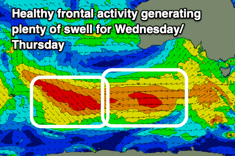 The first pulse of mid-period SW swell for Tuesday looks to come in around the 4ft+ range across Middleton, with Wednesday seeing a mix of slightly bigger swells to 4-5ft. The Mid Coast looks to be in the 2ft range on Tuesday, smaller and to 1-2ft on Wednesday and Thursday and with poor, strong S/SW winds across all locations Tuesday, improving later and swinging W/SW with better W/NW breezes on Wednesday morning down South before reverting back to the W/SW.
As the surf eases on Thursday winds look to shift more S'ly, though without any major strength but adding bumps to the South Coast. The Mid should become cleaner but it'll be easing in size from an inconsistent 1-2ft.
From Friday onwards a high looks to move in bringing favourable morning offshore winds ahead of weak sea breezes and with fun, reinforcing pulses of mid-period S/SW swell. More on this Monday. Have a great weekend!