Poor outlook until the weekend

South Australian Surf Forecast by Craig Brokensha (issued Monday December 6th)
Best Days: South Coast for the keen mid-late morning Saturday, Sunday morning South Coast
Features of the Forecast (tl;dr)
- Fresh to strong S/SW-S winds tomorrow, strong S/SE Wed and Thu, fresh SE tending S/SE Fri
- Mix of S/SE windswell and SW swell Wed-Fri
- New, mid-period S/SW swell later Fri, peaking Sat AM with E/NE tending S/SE winds
- Easing swell Sun with N/NE tending SE winds
Recap
Friday's great pulse of W/SW groundswell cleaned up late in the day with improving though full 2-3ft sets on the swell magnets, easing back into Saturday morning to a less consistent 2ft across the reefs and beaches.
Sunday saw waves more suited to beginners with clean 1-1.5ft waves while there's nothing left into the start of the week.
The South Coast was bumpy but with a bit of size on Saturday morning, a little cleaner Sunday morning with an E/NE breeze and sets hanging in at 3ft across Middleton. Today the swell was smaller but winds variable, providing fun waves across exposed breaks ahead of a trough which has brought an onshore change.


Good size Friday afternoon and Saturday morning
This week and weekend (Dec 7 – 12)
Now that the surface trough has moved in, bringing today's change we've got a poor run of conditions and surf for the rest of the week.
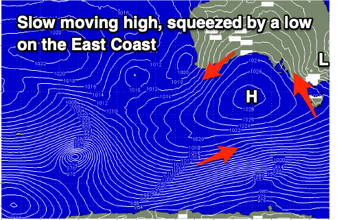 A strong high will try and move in from the west but the trough will deepen inland across NSW before deepening off their south coast, keeping the high at bay and directing persistent, strong S'ly winds into our South Coast.
Fresh to strong S/SW-S winds are due tomorrow with an early low point in swell, followed by some building windswell into the afternoon, then strong S/SE winds on Wednesday, similar Thursday but more fresh to strong.
Size wise, the local windswell looks to come in around 3ft across the Middleton stretch Wednesday through Thursday, and there'll be some inconsistent mid-period SW swell in the mix Thursday, though it's all academic with the local conditions.
The Mid Coast will be tiny to flat tomorrow with a possible tiny 1ft wave on Wednesday, easing back to 0.5-1ft on Thursday.
Friday will see winds shift SE but remaining fresh along with an average mix of swells.
As we move into the weekend we'll see the high moving further east as the low off the southern NSW coast pushes east towards New Zealand. This will allow winds to swing more E/NE through the morning with a mix of new, mid-period S/SW swell and easing S/SE windswell.
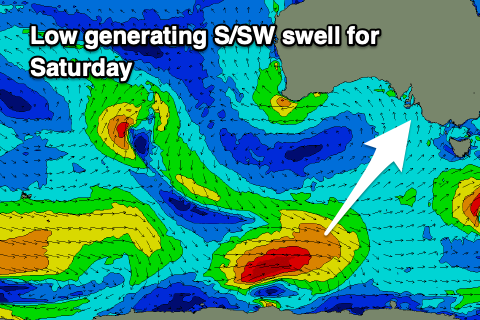 The mid-period swell will be generated by a small polar low firing up south of Western Australia tomorrow afternoon, projecting a fetch W/SW gales through our southern swell window. The swell should arrive later Friday but peak Saturday morning with sets to 3ft across Middleton, easing through the day. The Mid will be tiny to flat.
With the wind shifting E/NE through the morning we'll see peaky, lumpy but improving conditions, best before the S/SE sea breeze kicks in.
Sunday looks a bit cleaner with a N/NE offshore but smaller, easing mix of swells from 2ft+ or so across Middleton.
Moving into next week it looks like another trough will bring an onshore change on Monday and the slow moving nature of the high this week will keep things subdued swell wise through most of the week.
Longer term we may see a very inconsistent W/SW groundswell for late in the week, but we'll have to have a closer look at this on Wednesday.