Westerly swells take over from this afternoon

South Australian Surf Forecast by Craig Brokensha (issued Wednesday July 7th)
Best Days: South Coast today and the Mid Coast late, South Coast magnets tomorrow morning, Mid Cosat Saturday morning and Monday
Features of the Forecast (tl;dr)
- Building mid-period W'ly swell later today, easing tomorrow with fresh NE winds (fresh N/NE tending light NW on the Mid)
- Easing S'ly swell tomorrow
- Secondary mid-period W swell arriving late Fri, easing Sat AM with moderate NE tending light and variable N/NW winds Fri, light NE tending N Sat
- Stronger W/SW swell filling in Mon with moderate NW winds, easing later
- Easing W/SW swell Tue with fresh N/NE tending NW winds
Recap
The swell bottomed out yesterday with Middleton dropping back to 1-2ft with clean conditions, flat on the Mid, while our new mid-period S swell has provided fun 2-3ft waves down South, along with great conditions. The Mid Coast is again tiny but later today we should see some new W'ly swell building, hopefully reaching 1-2ft by dark as winds tend back to the NE.

Make the most of this!
This week and next (Jul 8 - 16)
Make the most of today's S'ly swell on the South Coast as we'll see it fading into tomorrow with not much at all to follow until at least late next week.
Conditions will be average at Middleton with a fresh NE'ly, better towards Goolwa and at other selected spots. Sets look to ease from 2ft, with Friday coming in tiny.
On the Mid Coast, a small, weak pulse of W'ly swell due late today should ease tomorrow from a small 1-2ft on the sets but with bumpy conditions owing to a fresh N/NE breeze, tending lighter NW into the afternoon.
We should see another similar sized pulse of weak W'ly swell arriving very late Friday and peaking Saturday morning, generated by a weak fetch of W/SW winds moving under WA and into the Bight tomorrow. Winds wont be as gusty as tomorrow though troublesome for the Mid Friday, moderate NE in the morning, shifting lighter and more variable N/NW late.
 Saturday morning should be clean with a light NE breeze, tending N'ly into the afternoon but variable late. This looks like the best window to target the new swell.
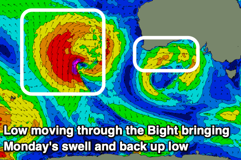
Our better W/SW swell for Sunday/Monday now looks to be moved back more to Monday, with a mid-latitude low passing under WA Saturday due to project strong W/SW winds towards us, weakening slowly Sunday.
The swell from this low should fill in Monday and build to 2-3ft through the day, likely 2ft early, with the South Coast hardly seeing much size at all, maybe building to 1-2ft. Winds look moderate from the NW, though easing into the afternoon creating improving conditions.
The swell will ease Tuesday from the 2ft range on the Mid Coast, 1-2ft across Middleton and with fresh N/NE tending NW winds. It's worth noting the models are over-forecasting Monday/Tuesday's size down South as it combines a small, long-period swell with the weaker W/SW swell.
Longer term, more mid-period W'ly swells are due through the rest of the week as mid-latitude lows dip east-southeast from WA, through the Bight bringing pulses of surf to 2-3ft or so but with poor W/NW-W/SW winds. The South Coast won't benefit owing to the westerly swell direction unfortunately. More on this Friday.
Comments
Can you give us an idea of size over the weekend for us weekend warriors pls Craig? Especially for those itching to try out a new sled just like me! :)
It's gonna be tiny to flat on the South Coast. Hence why I didn't bother mentioning. 0.5-1ft Middleton if that. Not much better on the magnets either.
Hi Craig, what sort of size do you think the mid coast will reach Saturday morning?
It's in the notes above.
Cheers mate, looks like the new sled might stay in the bag for another week! Huey, what a prick! Ha!
Perfect for windsurfing kiteboarding or Maricat surfing.
Northerly wind with a westerly groundie:)
Hey Craig, is there any sign ahead or change to the frontal activity coming more winter like ie. Sw/s in coming months or is your predicament the westerly storm track is hear to stay.:(
Unfortunately there's still no real end in sight with mid-latitude lows and fronts to continue.
what are the rough boundaries of the mid and south coast
The Mid is in the gulf, between O'Sullivan/Christies Beach and Port Willunga and the South Coast, Parsons to Goolwa.