Better weekend outlook for the South Coast

South Australian Surf Forecast by Craig Brokensha (issued Wednesday March 3rd)
Best Days: South Coast Saturday and Sunday mornings, Mid Coast Monday afternoon/evening for the keen and Tuesday, South Coast Thursday morning
Features of the Forecast (tl;dr)
- Low point in swell tomorrow with morning E'ly winds
- New mid-period S/SW swell building Fri but with E/SE-SE morning winds, stronger swell peaking Sat out of the S with E/NE morning winds, easing Sun with a morning N/NE breeze
- Inconsistent W/SW groundswell building for the Mid Mon, with a stronger SW groundswell Tue but with S/SW and SE-S/SE winds respectively
Recap
Slightly better winds and conditions than expected yesterday morning down South with a moderate to fresh E-E/NE breeze and 3ft of S/SW swell, flat on the Mid.
Today winds are out of the E again but with a weaker mix of smaller swells creating poor conditions and flat on the Mid.
This week and weekend (Mar 4 - 7)
The surf will remain average into the end of the week as winds persist out of the E each morning, light tomorrow but with a weak 2ft of S'ly swell, bumpier Friday with E/SE-SE winds and a building S/SW swell.
This S/SW swell and a stronger pulse for Saturday will be linked to a strengthening polar front firing up south-west of Tassie, in our southern swell window tomorrow.
The size off this system looks a touch better Saturday with it due to be a bit stronger. A fetch of strengthening strong to gale-force S/SW winds will fire up in our southern swell window, producing a mid-period S/SW swell for Saturday to 3ft+ across Middleton. Due to the southerly direction of the swell the Mid Coast will remain flat.
Winds still look favourable, tending E/NE through the morning, creating OK but far from perfect conditions before S/SE sea breezes kick in.
Sunday is now looking more favourable and a variable N/NE breeze as the swell easing back from 2-3ft across Middleton.
Next week onwards (Mar 8 onwards)
 We'll see a small surface trough bring onshore S/SW winds back to the fold on Monday with a low point in swell for the South Coast, though the Mid Coast may see a faint W/SW groundswell building to 1-1.5ft.
Our new groundswell mentioned last update is on track for Tuesday. Unfortunately so are the fresh to strong SE tending S/SE winds in the wake of the trough.
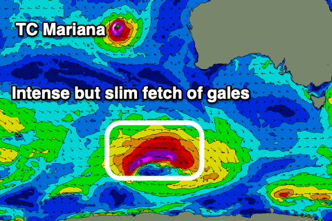
Looking at the swell though and a cold front pushing south-east from a position north of the Heard Island region, will form into a low south-west of WA. This will then see a slim fetch of severe-gale to near storm-force W/NW winds generated in our swell window, swinging more W while weakening south-west of Tassie on Sunday.
The swell is due to peak Tuesday to a strong 4ft across Middleton with 1-1.5ft sets on the Mid Coast, easing Wednesday with E/SE winds. Thursday looks cleaner down South but the swell will be smaller and on the way out. More on this in Friday's update though.