Easing surf ahead of a new westerly swell on the weekend

South Australian Forecast by Craig Brokensha (issued Wednesday 9th September)
Best Days: Both coasts tomorrow, South Coast magnets for the desperate Friday, late on the Mid Coast, both coasts Saturday, Mid Coast Sunday
Recap
Average conditions across the South Coast yesterday though with a building swell, onshore and bumpy to 2ft on the Mid Coast, becoming more consistent and to 2-3ft through the afternoon with a weaker onshore breeze.
Today the swell has cleaned up nicely with 2-3ft sets on the Mid Coast swell magnets with a peak in W/SW groundswell, lumpy and OK for the keen down South with 3ft sets across Middleton.

The Mid at dawn today
This week and weekend (Sep 10 – 13)
Today's mix of W/SW groundswell and mid-period energy are expected to ease through tomorrow as winds improve and swing more NE down South, favouring selected spots down South. Middleton should ease from 2-3ft with easing 2ft sets on the Mid Coast swell magnets working the favourable parts of the tide.
Moving into Friday the South Coast looks to remain small and to an infrequent 1-2ft as winds strengthen from the N/NE-NE, easing later afternoon and swinging more N'th. A new inconsistent W/SW groundswell should fill in through the afternoon as well keeping 1-2ft sets hitting the Mid Coast (possibly 1-1.5ft early), with the swell easing into Saturday.
A late change on Friday looks weak and winds look to revert back to variable tending light offshores on Saturday morning along with a drop in Friday's W/SW groundswell.
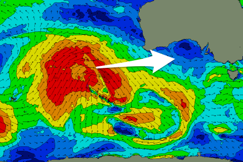 A new long-period W/SW groundswell should build into the afternoon though and peak Sunday morning, produced by a significant though distant storm in the south-east Indian Ocean the last couple of days.
This swell will be very inconsistent but the Mid Coast should see 2ft sets later Saturday, similar Sunday. There's the chance for the odd bigger one but expect mostly 2ft surf. The South Coast should peak around 2-3ft across Middleton later Saturday and through Sunday.
A broader high will fill in Saturday afternoon and bring S/SE winds on Sunday morning, favouring the Mid Coast ahead of afternoon sea breezes.
Next week onwards (Sep 14 onwards)
The more promising developments into next week are on track, with a conveyer belt of polar frontal activity due to move in from the west over the weekend and through next week.
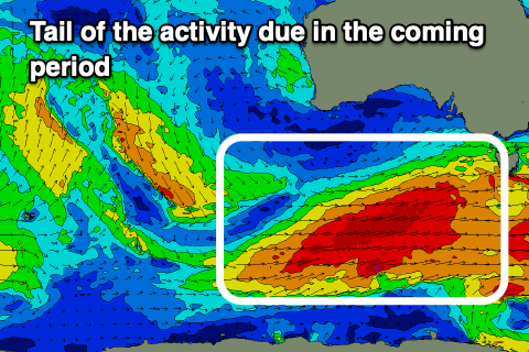 This will be linked to a drawn out node of the Long Wave Trough pushing in slowly from the west and just under us.
We'll see a bunch of strong polar fronts moving on top of each other, generating a moderate to large swell event from Monday through Thursday next week, likely peaking Tuesday/Wednesday. Size wise it looks to be in the range of 4-5ft across the South Coast and 1-2ft on the Mid Coast, but more on this Friday.