Nothing special for the weekend, better waves mid-late next week

South Australian Forecast by Craig Brokensha (issued Friday 10th July)
Best Days: South Coast magnets tomorrow, keen surfers on the Mid, South Coast Tuesday morning, South Coast Wednesday, both coasts Thursday, South Coast Friday
Recap
Tiny and bumpy waves on the Mid Coast building to 1ft on the sets, with a touch more energy today though only 1-1.5ft and with very average conditions. The South Coast remained small and clean with 1-2ft waves at Middleton and favourable winds most of the day, similar today.
Make the most of the small clean waves on the South Coast today as we're up for a run of average surf until mid-late week.
This weekend and next week (Jul 11 - 17)
A broad mid-latitude low/trough is moving in from the west and this will see favourable N/NW winds tomorrow morning, though tending variable ahead of a late S/SW change. This should open up some fun windows for a surf down South with background energy to an inconsistent 1-2ft off Middleton.
We'll also see the weak W/SW swell from the low persisting on the Mid to 1-1.5ft, possibly hitting 2ft on the sets across magnets on the favourable parts of the tide (decent with the variable winds).
 Sunday now looks average across all locations with a change delayed until dawn, bringing strong S/SW winds right on sunrise, possibly variable early on the Mid before kicking in out of the S/SW. Winds should swing back to the S/SE late in the day but we'll see fading W/SW swell from 1-1.5ft max.
With no new swell and lingering S/SE winds, Monday will be poor, with a slow improvement in winds on Tuesday, swinging E/NE-NE through the morning down South, E/SE on the Mid.
A new and very inconsistent long-period W/SW groundswell should fill in Tuesday but there'll be no major size attached to it, with it generated by a vigorous storm that developed south-east of South Africa. Middleton should see lined up and infrequent 2ft sets, 1ft on the Mid Coast and with those easterly winds.
Wednesday looks a similar size but with better N/NE tending E/NE winds, favouring the South Coast's exposed breaks.
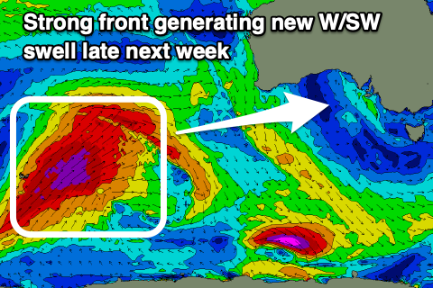
Our better pulse of W/SW groundswell for Thursday is on track but the storm firing up east of the Heard Island region will project more towards Indonesia now instead of us, resulting in a touch less size and later arrival.
We should see inconsistent sets building to 3ft across Middleton, if not for the odd bigger one at Goolwa, and an inconsistent 1-2ft on the Mid Coast later Thursday, easing from a similar size Friday. Conditions will be best for the South Coast Friday though with freshening N'ly winds.
Longer term an even better long-period and strong W/SW groundswell is on the cards for next weekend, but more on this Monday. Have a great weekend!