Small run of surf ahead of some new energy mid-late next week

South Australian Forecast by Craig Brokensha (issued Wednesday 8th July)
Best Days: Today down South, South Coast magnets tomorrow and Friday, Mid Coast for the keen Sunday morning, both coasts Wednesday and Thursday next week
Recap
The afternoon pulse of tiny though surfable W/SW swell seen Monday afternoon on the Mid happened again yesterday but with less consistency. The South Coast was good to great with 3ft of S/SW swell and clean conditions across spots that love a NE breeze.
This morning the swell is hanging in there with clean and consistent 3ft sets out of the south along the Middleton stretch, tiny on the Mid and becoming slightly wind affected.

This week and next (Jul 9 - 17)
Make the most of today's size, as the reinforcing S/SW swell from the polar low earlier this week will drop steadily from later today and be small tomorrow.
 Smaller and leftover 2ft sets are due across Middleton, better on the swell magnets with great moderate to fresh but easing N/NE tending N winds.
Friday and Saturday will be small to tiny on the South Coast, with background energy keeping stray and inconsistent 1-2ft sets hitting Middleton to Goolwa with favourable N/NW winds on Friday, less so Saturday as a change moves through swinging morning W/SW winds to a strong SW.
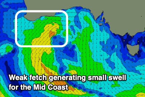
Looking at the Mid Coast, the run of weak W/SW swell from Thursday through Saturday is still on track, with a weak though persistent mid-latitude low that's currently moving in from the west. A fetch of strong W/SW winds moving under WA will broaden today and tomorrow, with a slight intensification Friday morning.
This should see building surf from 1ft tomorrow to 1-1.5ft surf through Friday and Saturday but there may be the stray 2ft set on the magnets on the latter, then easing from 1-1.5ft Sunday.
Conditions will be average though with the northerly winds Friday, and then onshore westerly breezes Saturday. Sunday still looks fun with a morning SE breeze, poor and onshore down South with the lack of size.
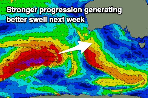 Longer term, early next week will remain tiny as winds slowly improve, swinging from south-east to north-east and from Tuesday and more so Wednesday we should see some new inconsistent W/SW groundswell filling in from the Indian Ocean.
The first swell that's due Tuesday will be generated over the coming days by a vigorous storm south-east of Madagascar will produce a slow increase in size Tuesday, reaching an inconsistent 2ft on the sets across Middleton, 1ft on the Mid Coast., holding Wednesday.
A slightly better W/SW groundswell is due later in the day and more so Thursday, produced by a secondary significant storm forming east of the Heard Island region this weekend. A better, bigger and more consistent swell should be seen, providing 3ft+ sets across Middleton, with 1-2ft sets on the Mid Coast. We'll have a closer look at this on Friday.