A continuation of good conditions down South with fun swells

South Australian Forecast by Craig Brokensha (issued Friday 15th May)
Best Days: South Coast tomorrow and Sunday, both coasts Monday, keen surfers Mid Coast Tuesday, better South Coast
Recap
Good waves across both coasts yesterday with clean 1-2ft sets on the Mid Coast all day, easing slowly from 3-4ft on the South Coast with generally favourable winds.
This morning conditions are great down South and with 2-3ft sets hanging in at Middleton, back to 1ft on the Mid.

Cliffs this morning
This weekend and next week (May 16 - 22)
The swell should drop back a bit more tomorrow across the South Coast though not below 2ft off Middleton, tiny on the Mid Coast.
Conditions will be great for the swell magnets with a light to moderate N/NW-N breeze ahead of weak and possibly variable sea breezes.
Our new W/SW groundswell for Sunday is still on track, but there'll also be a fun SW groundswell component to it now, favouring the South Coast.
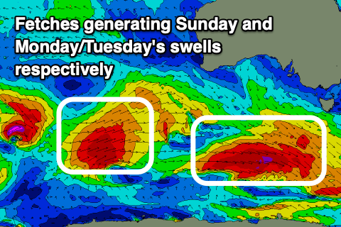 The W/SW groundswell has been generated by mixed fetches of gales west-southwest of WA and we should see inconsistent sets building to 1-2ft on the Mid Coast through the afternoon with the help of the tide, tiny in the morning. The South Coast should be 2-3ft in the morning off Middleton from the SW groundswell which was generated yesterday evening and this morning by a re-intensification of W'ly gales south-west of us.
A touch more size is due into the afternoon more to 3ft or so. Winds are looking favourable for both coasts with morning offshores, though shifting E/SE down South into the afternoon, more variable on the Mid Coast.
Our stronger and better W/SW groundswell for Monday and Tuesday is still on track with a good but distant polar front generating a fetch of W/SW gales through our western swell window as it projects east-northeast towards WA today, weakening tomorrow south of their state.
The groundswell should build Monday afternoon, kicking to a good 2-3ft on the Mid Coast swell magnets, 4ft on the sets off Middleton, easing back slowly from a similar size on Tuesday morning.
A secondary smaller but still strong mid-latitude front should produce a reinforcing W/SW swell for Tuesday afternoon, keeping the Mid Coast around 2ft+, easing from 2ft on the sets Wednesday morning. The South Coast will just ease slower, dropping from 2-3ft Wednesday morning.
Locally winds look favourable though getting windy for the Mid with Monday seeing fresh NE-N/NE winds, tending variable into the afternoon and then fresh N/NE all day Tuesday. Wednesday is still unsure as we may see a strong mid-latitude move in from the west, bringing onshore winds, so we'll have to review this again Monday. Have a great weekend!