Good W/SW swell on the way

South Australian Forecast by Craig Brokensha (issued Monday 11th May)
Best Days: South Coast magnets tomorrow, Mid Coast Wednesday, both coasts Thursday, Friday and Saturday South Coast swell magnets
Recap
Smallish and bumpy waves on the South Coast Saturday, though our new S/SW groundswell provided large waves into Sunday with weaker and workable winds. Conditions were good for experienced surfers.
The Mid Coast was a choppy 2-3ft on Saturday but Sunday was much cleaner than expected with early variable winds and clean fun 2-3ft surf.
Today both coasts are good with cleaner conditions and 3-4ft sets off the South Coast, 1-2ft on the Mid, though now a bit wind affected.
This week and weekend (May 12 - 17)
We'll see the swell continue to fade into tomorrow across both coasts ahead of a new W/SW groundswell possibly showing late in the day but peaking Wednesday.
The South Coast looks to ease back to 2ft tomorrow across Middleton, 1ft+ on the Mid Coast with fresh N/NW tending NW winds.
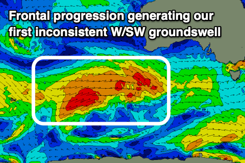 The new W/SW groundswell was generated over the weekend but a strong frontal progression that fired up west-southwest of WA. A fetch of W/SW gales were generated through our western swell window, and the progression is currently weakening south of WA, with the weaker remnants due to move in and towards us today.
A moderate sized W/SW groundswell is due from this source, possibly showing later tomorrow but peaking Wednesday to 2ft to occasionally 3ft on the favourable parts of the tide across swell magnets on the Mid Coast, 3ft+ off Middleton and 3-4ft at Goolwa.
We've still got that swing in winds to the S/SE on Wednesday as a surface trough moves through, and this will favour the Mid Coast while creating average conditions down South.
 Thursday should see winds become more variable and locally offshore across both regions as the W/SW swell eases, though reinforced down South by a new mid-period S/SW swell. This will be generated by the remnants of the front linked to the W/SW swell firing up south-west of Victoria tomorrow.
The S/SW swell will slow the easing trend down South with Middleton likely to see 3ft to possibly 4ft sets, easing through the day and much smaller and down to 2ft through Friday. The Mid Coast looks to ease back from 2ft on the sets, tiny Friday. N/NE winds will favour the swell magnets on the South Coast Friday as the swell fades, with Saturday remaining clean but only small and 1-2ft off Middleton.
Longer term a conveyer belt of frontal systems through the Southern Ocean should generate some new small mid-period swell for later Saturday but a stronger intensification within this progression may generate a better groundswell for Sunday/Monday. Unfortunately it looks like another trough will bring onshore S/SE winds Sunday, possibly NE on Monday as the swell eases, but we'll have to look at the expected size and timing again on Wednesday as the models slightly diverge on the intensity of this strong front.