Small swells with favourable winds, better energy from late Sunday

South Australian Forecast by Craig Brokensha (issued Wednesday 27th February)
Best Days: South Coast magnets tomorrow morning, South Coast magnets Saturday afternoon, Mid Coast later Sunday and Monday, South Coast Tuesday morning, both coasts next Thursday
Recap
Poor building surf down South with onshore winds, clean and tiny on the Mid to 0.5-1ft but kicking to the expected 1.5ft with the incoming tide later in the day.
This morning the surf was a little cleaner though still average on the South Coast, clean and tiny on the Mid again.
Today’s Forecaster Notes are brought to you by Rip Curl
This week and weekend (Feb 28 – Mar 3)
Yesterday's W/SW swell on the Mid Coast and today's SW swell across the South Coast will both ease into tomorrow, further Friday but conditions are now looking cleaner for the South Coast.
A light variable wind tending N'ly wind through the morning should create clean fun waves off the South Coast but the swell will be small and easing from 2ft max off Middleton, tiny on the Mid Coast.
Friday is still looking clean but with no size at all, likely not even 1-2ft at Waits and Parsons and with a N/NE offshore.
Moving into Saturday and conditions will be clean again with a hot N'ly wind, and our change has been delayed, with winds now only expected to swing W/NW into the afternoon.
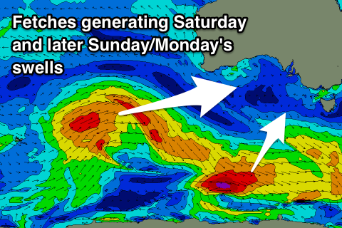
We'll be starting from a low and tiny base, but a new inconsistent S/SW groundswell should build through the day, offering options at swell magnets. This is being generated by a polar fetch of gale to severe-gale W/NW winds that aren't aimed well for us at all.
 As a result Middleton isn't likely to get above 1-2ft, with 2ft to possibly 3ft sets at Waits and Parsons into the afternoon, easing Sunday with poor S'ly winds after a change Saturday evening.
Of greater importance is a good new W/SW groundswell due later Sunday and Monday, generated by a strong but distant storm firing up west-southwest of WA today and tomorrow.
An initial fetch of gale-force W/SW winds will be projected through our western swell window, weakening while pushing towards the south of WA and into the Bight Friday afternoon.
A moderate sized W/SW groundswell should be seen of this source, building Sunday afternoon and peaking Monday morning. The Mid Coast should see good 1-2ft sets developing Sunday afternoon, holding 2ft Monday, while Middleton will see less size with the westerly direction, coming in at 2-3ft on Monday. A SE wind will create great conditions on the Mid Coast, E/NE down South on Tuesday as the swell eases.
Following this swell, a larger and long-period though inconsistent SW groundswell is due later in the week. This will be generated by another very distant but strong storm, with a low forecast to develop north of the Heard Island region this weekend, moving slowly east while generating a fetch of severe-gale to storm-force W'ly winds. The storm is expected to weaken south of WA early next week, with the strong though inconsistent groundswell arriving late Wednesday and peaking through Thursday.
At this stage Middleton looks to come in at 4-5ft with fun 1-2ft waves on the Mid Coast and with what looks to be offshore winds. We may see a secondary slightly stronger swell next weekend, but more on this and next week's swell Friday.