Very mixed forecast that's all about timing the windows

South Australian Forecast by Craig Brokensha (issued Wednesday 29th August)
Best Days: South Coast tomorrow (likely afternoon), and magnets Friday morning, Saturday morning protected spots South Coast, keen surfers Monday morning South Coast, Tuesday South Coast
Recap
The surf did clean up a bit into yesterday but winds out of the north-eastern quadrant favoured only a few selected spots with easing 2-3ft sets off Middleton and 0.5-1ft sets on the Mid Coast.
This morning is average with a low point in swell and less than ideal E/NE-NE winds, flat on the Mid Coast. We should see a new S/SW groundswell building later today with better conditions under a hopefully straighter N/NE breeze.
Today’s Forecaster Notes are brought to you by Rip Curl
This week and weekend (Aug 30 – Sep 2)
Later today's increase in groundswell is due to peak overnight and ease back through tomorrow but with strong and easing N/NE tending N/NW winds.
With this in mind the early might not be the best, though it will be the biggest with easing sets from 3ft off Middleton, smaller and likely cleaner through the afternoon. The Mid Coast isn't expected to seen any real size above 0.5-1ft max.
Friday morning looks hit and miss with a low point in swell and fresh NW tending W/NW and then W/SW breezes. With this change the Mid Coast is likely to see an increase in W/SW windswell, but tiny and likely only to 1-1.5ft late.
The South Coast will also see some new S/SW groundswell building through the afternoon and hold Saturday, produced by a polar fetch of W/NW gales, followed by W/SW gales.
 The W/NW fetch will generate Friday afternoon's increase, with Middleton likely to kick to 2-3ft by dark, but with that poor onshore wind.
Saturday will reveal more size with 3ft sets off Middleton from the W/SW fetch, but winds are also not ideal, possibly W'ly at dawn and then swinging W/SW-SW through the day and S/SW into the afternoon as a cold front clips the state. The Mid Coast will remain tiny and to 1ft.
Our models are showing a large increase in size through the day Saturday, but this is not likely to happen, with what looks to be the incorrect combination of windswell and S/SW groundswell.
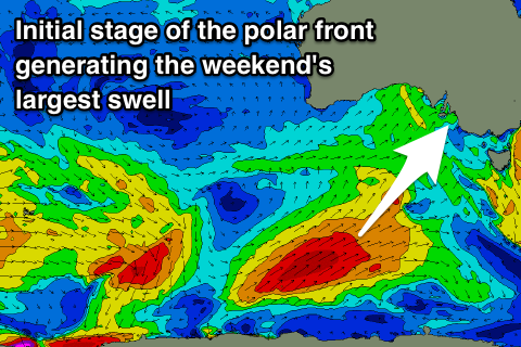
Into Sunday however we should see a larger and more powerful S/SW groundswell filling in, generated by a strong polar front forming south-southwest of WA tomorrow afternoon projecting a fetch of SW gales up through our southern swell window before passing under Tassie Saturday evening.
We'll see a large S/SW groundswell filling in Sunday, building to 5-6ft off Middleton into the afternoon, smaller and likely only around 4ft or so through the morning. With the south direction the Mid Coast will struggle to get above 1ft though conditions will be clean with a E/SE offshore.
The South Coast is looking average with onshore winds only due to swing light E/SE through the morning, leaving lots of lump and bump on the coast. The afternoon will likely be better with the stronger swell overpowering the weak S/SE sea breeze.
Moving into next week, we'll see conditions slowly improve with a NE offshore Monday as the swell eases back from 4-5ft off Middleton, better Tuesday with a N/NE breeze and likely small new long-period S/SW groundswell for the afternoon. More on this Friday.