Average and easing S/SE windswell as winds improve

South Australian Forecast by Craig Brokensha (issued Friday 2nd February)
Best Days: Desperate surfers protected spots from the wind but open to the swell Sunday morning, and Monday morning
Recap
Tiny fading surf on the Mid Coast yesterday, flat today with a continuation of poor S/SE windswell across the South Coast. Lighter winds created slightly better conditions this morning but the swell was still very poor.
Today’s Forecaster Notes are brought to you by Rip Curl
This weekend and next week (Feb 3 - 9)
Unfortunately there's no change to the short-term forecast with the weekend due to see small levels of poor S/SE windswell along with fresh E/SE tending S/SE winds tomorrow, a touch weaker and likely tending E/NE Sunday morning. The swell will be average and only around 2ft+ or so.
The Mid Coast won't see any swell at all with the S/SE windswell direction and no additional W/SW-SW groundswell.
Monday morning should reveal similar E/NE winds down South though with a smaller weak easing S/SE windswell from the 2ft range.
Our further improvement in winds is still on the cards for Tuesday, though the models are slightly divergent with the European version showing morning SE winds, while the American version is sticking with NE winds, which is more likely the case.
 Swell wise though there's nothing at all on the cards with the blocking high responsible for our poor winds, deflecting any swell generating systems away from us.
We'll have offshore winds but tiny surf, similar Wednesday until a new trough and high move in from the west Thursday bringing S/SE winds.
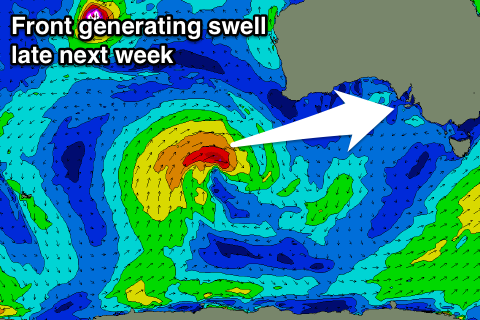
Prospects later week and into the weekend are much better with a slow moving mid-latitude frontal progression pushing up towards WA due to generate some good W/SW groundswell for Thursday afternoon/Friday, followed by some SW energy, but more on this Monday. Have a great weekend!